- Chugul Island
-
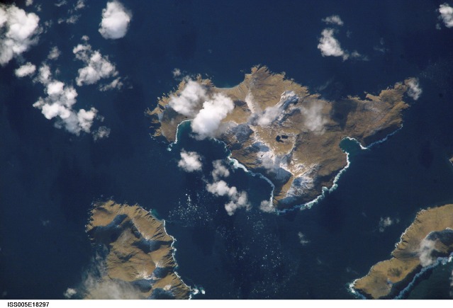
Chugul Island NASA-Bild von Chugul Island
Gewässer Pazifischer Ozean Inselgruppe Aleuten Geographische Lage 52° 4′ 57,9″ N, 178° 59′ 59,24″ W52.082751-178.999789Koordinaten: 52° 4′ 57,9″ N, 178° 59′ 59,24″ W 

Einwohner (unbewohnt) Chugul ist eine kleine Insel in der Mitte der Andreanof Islands, die zu den Aleuten gehören. Neben Chugul gibt es noch weitere kleine Inseln, die in der Seestraße zwischen Adak und Atka liegen. Die beiden nächstgelegenen Inseln sind Igitkin und Tagalak.
Weblinks
- Chugul Island im Geographic Names Information System des United States Geological Survey (englisch)
- Bild und Kurzbeschreibung auf Oceandots.com (englisch)
Inseln und Inselgruppen der Andreanof IslandsAdak | Agligadak | Amatigis Islands | Amlia | Anagaksik | Argonne | Asuksak | Atka | Aziak | Barbara | Black | Bobrof | Bolshoi Islands | Box | Castle | Chaika Rock | Channel | Chisak | Chugul | Cone | Cormorant | Crone | Delarof Islands | Dora | Eddy | Elf | Fenimore Rock | Gramp Rock | Great Sitkin | Green | Igitkin | Ikiginak | Ina | Kagalaska | Kanaga | Kanu | Kasatochi | Koniuji | Little Tanaga | North | Oglodak | Plum | Ringgold | Sadatanek | Sagchudak | Sagigik | Salt | Sea Parrot | Seguam | Silak | South | Staten | Tagadak | Tagalak | Tanaga | Tanaklek | The Signals | The Three Sisters | Tidgituk | Umak | Uyak | Whip
Wikimedia Foundation.
Schlagen Sie auch in anderen Wörterbüchern nach:
Chugul Island — Location in Alaska Chugul i … Wikipedia
Île Chugul — Vue aérienne de l île. Géographie Pays … Wikipédia en Français
Chagulak Island — Chagulak Höhe 1.142 m … Deutsch Wikipedia
Chagulak Island — Location in Alaska … Wikipedia
Umak Island — Vorlage:Infobox Insel/Wartung/Bild fehltVorlage:Infobox Insel/Wartung/Fläche fehltVorlage:Infobox Insel/Wartung/Höhe fehlt Umak Island Gewässer Pazifischer Ozean Inselgruppe Aleuten … Deutsch Wikipedia
Nunivak Island — Nunivak Maskette – Nunivak … Wikipedia
Medny Island — Map showing position of Commander Islands to the east of Kamchatka. The smaller island in the east is Medny and the larger island is Bering Island. Medny Island (also spelled Mednyy, Russian: остров Медный, sometimes called Copper Island in… … Wikipedia
Unalaska Island — Unalaska Native name: Nawan Alaxsxa[1] Map of the island … Wikipedia
Nelson Island (Alaska) — Nelson Native name: Qaluyaaq … Wikipedia
Adak Island — Mount Adagdak Gewässer Pazifischer Ozean Inselgruppe … Deutsch Wikipedia
Chugul Island

18+
© Academic, 2000-2026
- Kontaktieren Sie uns: Unterstützung, Werbung
Wörterbücher Export, schritte mit PHP, Joomla, Drupal, WordPress, MODx.