- Kuchyňa
-
Kuchyňa
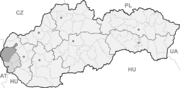
Wappen Karte 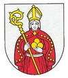

Kuchyňa BasisdatenKraj: Bratislavský kraj Okres: Malacky Region: Záhorie Fläche: 45,134 km² Einwohner: 1.713 (31. Dez. 2010) Bevölkerungsdichte: 37,95 Einwohner je km² Höhe: 253 m n.m. Postleitzahl: 900 52 Telefonvorwahl: 0 33 Geographische Lage: 48° 24′ N, 17° 9′ O48.40694444444417.155555555556253Koordinaten: 48° 24′ 25″ N, 17° 9′ 20″ O Kfz-Kennzeichen: MA Gemeindekennziffer: 508021 StrukturGemeindeart: Gemeinde Verwaltung (Stand: November 2010)Bürgermeister: Róbert Bujna Adresse: Obecný úrad Kuchyňa
220
90052 KuchyňaWebpräsenz: www.obeckuchyna.sk Gemeindeinformation
auf portal.gov.skStatistikinformation
auf statistics.skKuchyňa (deutsch Kuchel, ungarisch Konyha) ist eine Gemeinde im äußersten Westen der Slowakei. Sie liegt im Záhorie-Tiefland am Fuße der Kleinen Karpaten, 18 km von Malacky und 43 km von Bratislava entfernt.
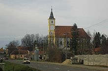 Kirche des hl. Michael
Die erste schriftliche Erwähnung erfolgte im Jahr 1206 als Cuhnamezei.
Westlich der Gemeinde befinden sich der Truppenübungsplatz Záhorie und ein Militärflugplatz (ICAO-Code: LZMC).
Weblinks
 Commons: Kuchyňa – Sammlung von Bildern, Videos und AudiodateienGemeinden im Okres Malacky
Borinka (Ballenstein) | Gajary (Gayring) | Jablonové (Apfelsbach) | Jakubov (Jakobsdorf) | Kostolište (Kirchenplatz) | Kuchyňa (Kuchel) | Láb (Laab) | Lozorno (Losorn) | Malacky (Malatzka) | Malé Leváre (Kleinschützen) | Marianka (Mariental) | Pernek (Bäreneck) | Plavecké Podhradie (Blasenstein) | Plavecký Mikuláš (Blasenstein-Sankt-Niklaus) | Plavecký Štvrtok (Zankendorf) | Rohožník (Rohrbach) | Sološnica (Breitenbrunn) | Studienka (Hausbrunn) | Stupava (Stampfen) | Suchohrad (Dimburg) | Veľké Leváre (Großschützen) | Vysoká pri Morave (Hochstetten) | Záhorie (Militärbezirk) | Záhorská Ves (Ungeraiden) | Závod | Zohor (Sachern)
Wikimedia Foundation.
Schlagen Sie auch in anderen Wörterbüchern nach:
Kuchyna — Kuchyňa Wappen Karte … Deutsch Wikipedia
Kuchyňa — is a municipality in the Malacky District in the Bratislava Region of western Slovakia close to the town of Malacky, north west of Slovakia s capital Bratislava.The Kuchyňa airbase, often used by the US Air Force for training purposes, is located … Wikipedia
Kuchyňa (district Malacky) — Kuchyňa (Village) Administration Pays Slovaquie … Wikipédia en Français
Záhorie (Ort) — Záhorie Wappen Karte … Deutsch Wikipedia
Slovak Air Force — Infobox Military Unit unit name= Slovak Air Force caption= dates= 1939 1945 1993 2008 country= Flag|Slovakia allegiance= branch= type= role= size= 46 aircraft command structure= garrison= garrison label= nickname= patron= motto= colors= colors… … Wikipedia
Malacky Air Base — Kuchyňa Air Base IATA: none – ICAO: LZMC Summary Airpo … Wikipedia
Malacky — Coordinates: 48°26′09″N 17°01′04″E / 48.43583°N 17.01778°E / 48.43583; 17.01778 … Wikipedia
Vysoká (Carpathian mountain) — Infobox Mountain Name = Vysoká Photo = Caption = View from Vysoká Elevation = 754 m Coordinates = coord|48|25|4.69|N|17|13|13.84|E|region:CH type:landmark Location = Malé Karpaty ( Little Carpathians ) Easiest route = from Zochova chataVysoká is… … Wikipedia
List of New Jersey Devils draft picks — Jacob Josefson was the Devils first pick in the 2009 NHL Entry Draft. The New Jersey Devils are a professional ice hockey team based in Newark, New Jersey. They are members of the Atlantic Division of the Eastern Conference of the National Hockey … Wikipedia
Liste der Städte und Gemeinden in der Slowakei/H-Ľ — Übersicht H bis Ľ Teil 1 A bis G Teil 2 H bis Ľ Teil 3 M bis R Teil 4 S bis Ž Übersicht H CH I J K L Ľ H Städte und Gemeinden … Deutsch Wikipedia
Kuchyňa


18+
© Academic, 2000-2026
- Kontaktieren Sie uns: Unterstützung, Werbung
Wörterbücher Export, schritte mit PHP, Joomla, Drupal, WordPress, MODx.