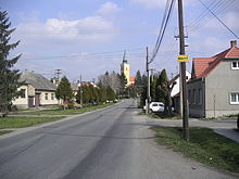
- Kostolište
-
Kostolište
Wappen Karte  Basisdaten
Kraj: Bratislavský kraj Okres: Malacky Region: Záhorie Fläche: 16,825 km² Einwohner: 1.205 (31. Dez. 2010) Bevölkerungsdichte: 71,62 Einwohner je km² Höhe: 164 m n.m. Postleitzahl: 900 62 Telefonvorwahl: 0 34 Geographische Lage: 48° 27′ N, 16° 59′ O48.44583333333316.986388888889164Koordinaten: 48° 26′ 45″ N, 16° 59′ 11″ O Kfz-Kennzeichen: MA Gemeindekennziffer: 508012 StrukturGemeindeart: Gemeinde Verwaltung (Stand: März 2011)Bürgermeister: Hubert Danihel Adresse: Obecný úrad Kostolište
Hlavná 66
90062 KostolišteWebpräsenz: www.kostoliste.sk Gemeindeinformation
auf portal.gov.skStatistikinformation
auf statistics.skKostolište (slowakisch bis 1948 „Kiripolec“ - bis 1927 „Kiripolce“; deutsch selten Kirchenplatz, ungarisch Egyházhely - bis 1907 Kiripolc) ist eine Gemeinde im Okres Malacky innerhalb des Bratislavský kraj in der Slowakei.
Inhaltsverzeichnis
Geographie
Der Ort liegt in der Záhorská nížina (Záhorie-Tiefland) in der Záhorie und befindet sich nur 4 km westlich der Stadt Malacky.
Geschichte
Im Katastralgebiet der heutigen Gemeinde entstand kurzzeitig am Ende des 4. Jahrhunderts eine römisch-barbarische Siedlung. Kostolište wurde zum ersten Mal in einer Urkunde aus dem Jahr 1271 als Kilpiruis erwähnt.
Persönlichkeiten
- Martin Benka, slowakischer Maler
Weblinks
Borinka (Ballenstein) | Gajary (Gayring) | Jablonové (Apfelsbach) | Jakubov (Jakobsdorf) | Kostolište (Kirchenplatz) | Kuchyňa (Kuchel) | Láb (Laab) | Lozorno (Losorn) | Malacky (Malatzka) | Malé Leváre (Kleinschützen) | Marianka (Mariental) | Pernek (Bäreneck) | Plavecké Podhradie (Blasenstein) | Plavecký Mikuláš (Blasenstein-Sankt-Niklaus) | Plavecký Štvrtok (Zankendorf) | Rohožník (Rohrbach) | Sološnica (Breitenbrunn) | Studienka (Hausbrunn) | Stupava (Stampfen) | Suchohrad (Dimburg) | Veľké Leváre (Großschützen) | Vysoká pri Morave (Hochstetten) | Záhorie (Militärbezirk) | Záhorská Ves (Ungeraiden) | Závod | Zohor (Sachern)
Wikimedia Foundation.


