- Portlock Island
-
Portlock Island Landsat-Bild der Kulbi-Inseln: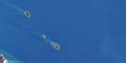
Portlock ist die unterste (südlichste) der drei Inseln.Gewässer Pazifischer Ozean Inselgruppe Kulbi-Inseln Geographische Lage 10° 7′ 0″ S, 142° 21′ 31″ O-10.116666666667142.35861111111Koordinaten: 10° 7′ 0″ S, 142° 21′ 31″ O Länge 500 m Breite 300 m Fläche 0.12 km² Einwohner (unbewohnt) Karte der Torres-Strait-Inseln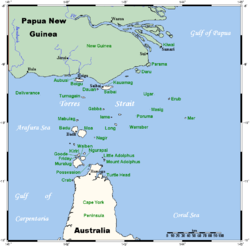
Portlock Island, auch Kulbi Island genannt, ist eine kleine, unbewohnte Insel in der Torres-Straße im Pazifik nordöstlich von Moa Island. Mit der knapp 1,5 Kilometer nordwestlich gelegenen Insel Tobin zählt sie zur Gruppe der Kulbi-Inseln.
Der Inselname geht auf den britischen Marineoffizier Nathaniel Portlock (1747 - 1817) zurück.
Die flache Insel ist von einem dichten Saumriff umschlossen. Sie gehört geopolitisch zum australischen Bundesstaat Queensland.
Inselregionen, Hauptinseln und Inselgruppen im Archipel der Torres-Strait-Inselnzu Papua-Neuguinea gehörige Torres-Strait-Inseln: Bristow Island | Daru Island | Parama Island • Kawai-Inseln | Talbot-Inseln
Top Western: Boigu | Dauan | Deliverance | Saibai | Turnagain • Talbot-Inseln
Western: Badu | Mabuiag | Moa | Portlock | Tobin • Bellevue-Inseln | Duncan-Inseln | Farewell-Inseln | Kulbi-Inseln
Central: Aureed | Bourke | Coconut | Sassie | Sue | Yam | Yorke • Bourke-Inseln | Tetley-Inseln | The Three Sisters | Yorke-Inseln
Eastern: Bramble | Darnley | Murray | Stephens • Murray-Inseln
Inner: Albany | Booby | Crab | Entrance | Friday | Goods | Hammond | Horn | Packe | Port Lihou | Prince-of-Wales | Thursday | Wednesday • Manar-Inseln | Red-Wallis-Inseln | Thursday-Inseln | Tuesday-Inseln
Wikimedia Foundation.
Schlagen Sie auch in anderen Wörterbüchern nach:
Portlock — ist der Name von Nathaniel Portlock ( 1749–1817), britischer Marineoffizier und Entdecker Joseph Ellison Portlock (1794–1864), britischer Geologe und Soldat, Sohn des Nathaniel Portlock Geografisches Portlock Island, Australien … Deutsch Wikipedia
Portlock Islet — Portlock Island oder auch Portlock Islet ist eine kleine, unbewohnte Insel in der Torres Straße nordöstlich von Moa Island. Sie gehört zu Queensland, Australien und ist als Tauchrevier beliebt. 10.116666666667142.358611111117Koordinaten … Deutsch Wikipedia
Nathaniel Portlock — (* 1747 oder 1749 in Norfolk, Virginia; † 12. September 1817 im Greenwich Hospital in London) war ein britischer Marineoffizier und Entdecker im 18. Jahrhundert. Leben Portlock entstammte einer kleinbürgerlichen Familie … Deutsch Wikipedia
Tobin Island — w1Vorlage:Infobox Insel/Wartung/Höhe fehlt Tobin Island Landsat Bild der Kulbi … Deutsch Wikipedia
Thursday Island — Landsat Bild von Thursday Island (unten) und Hammond Island (oben) … Deutsch Wikipedia
Sassie Island — (Long Island) Landsat Bild von Sassie Island Gewässer Pazifischer Oze … Deutsch Wikipedia
Friday Island (Torres Strait) — Friday Island Landsat Bild von Friday Island Gewässer Pazifischer Ozea … Deutsch Wikipedia
Parama Island — (Bampton Island) Landsat Bild von Parama Island (Anm.: unter den Wolken!) Gewäss … Deutsch Wikipedia
Stephens Island (Torres Strait) — Stephens Island (Ugar) Landsat Bild der Insel mit dem wesentlich größeren umgebenden Korallenriff … Deutsch Wikipedia
Badu Island — w1 Badu Island Landsat Bild von Badu Island Gewässer Torres Straße … Deutsch Wikipedia
Portlock Island


18+
© Academic, 2000-2026
- Kontaktieren Sie uns: Unterstützung, Werbung
Wörterbücher Export, schritte mit PHP, Joomla, Drupal, WordPress, MODx.