- Goods Island
-
Goods Island
(Palilug)Landsat-Bild von Goods Island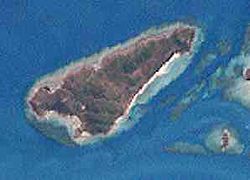
Gewässer Pazifischer Ozean Inselgruppe Thursday-Inseln Geographische Lage 10° 33′ 43″ S, 142° 9′ 36″ O-10.561944444444142.1667Koordinaten: 10° 33′ 43″ S, 142° 9′ 36″ O 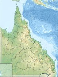

Länge 3,2 km Breite 1,2 km Fläche 2,14 km² Höchste Erhebung Hester Hill
67 mEinwohner (unbewohnt) Lage der Torres-Strait-Inseln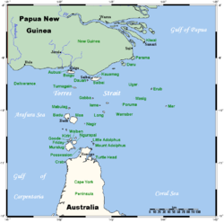
Goods Island, auch Palilug genannt, ist eine kleine Insel im Archipel der Torres-Strait-Inseln. Sie liegt im Nordwesten der Thursday-Inseln, 980 Meter westlich von Hammond Island, und ist von Thursday Island, der Hauptinsel in der Torres Strait, knapp fünf Kilometer entfernt.
Verwaltungstechnisch gehört Goods Island zu den Inner Islands, der südlichsten Inselregion im Verwaltungsbezirk Torres Shire des australischen Bundesstaats Queensland.
Die flache Insel ist etwa 3,2 Kilometer lang und im Durchschnitt weniger als einen Kilometer breit. Goods Island ist unbewohnt.
Siehe auch
Weblinks
Inselregionen, Hauptinseln und Inselgruppen im Archipel der Torres-Strait-Inselnzu Papua-Neuguinea gehörige Torres-Strait-Inseln: Bristow Island | Daru Island | Parama Island • Kawai-Inseln | Talbot-Inseln
Top Western: Boigu | Dauan | Deliverance | Saibai | Turnagain • Talbot-Inseln
Western: Badu | Mabuiag | Moa | Portlock | Tobin • Bellevue-Inseln | Duncan-Inseln | Farewell-Inseln | Kulbi-Inseln
Central: Aureed | Bourke | Coconut | Sassie | Sue | Yam | Yorke • Bourke-Inseln | The Three Sisters | Yorke-Inseln
Eastern: Bramble | Darnley | Murray | Stephens • Murray-Inseln
Inner: Albany | Booby | Crab | Entrance | Friday | Goods | Hammond | Horn | Packe | Port Lihou | Prince-of-Wales | Thursday | Wednesday • Manar-Inseln | Red-Wallis-Inseln | Thursday-Inseln | Tuesday-Inseln
Wikimedia Foundation.
Schlagen Sie auch in anderen Wörterbüchern nach:
Goods-Island — Goods Island, Insel an der Nordküste von Australien, in der Torresstraße … Pierer's Universal-Lexikon
Goods — ist der Name folgender Personen: Torsten Goods (* 1980), deutscher Jazzmusiker Goods bezeichnet außerdem: Goods Island (auch: Palilug), australische Insel Diese Seite ist eine Begriffsklärung … Deutsch Wikipedia
island display — ➔ display1 * * * island display UK US noun [C] ► MARKETING a shelf that stands by itself in a store and shows goods for sale on all sides: »An island display in the center of the aisle offered brands of detergent in every direction … Financial and business terms
Island of the Blue Dolphins — infobox Book | name = Island of the Blue Dolphins caption = Recent edition cover author = Scott O Dell illustrator = cover artist = Ted Lewin country = United States language = English series = genre = Children s novel publisher = Houghton… … Wikipedia
Moreton Island lighthouses — 1927 Plan of the northern tip of Moreton Island, showing the locations of Cape Moreton Light, North Point Light and Yellow Patch Light Moreton Island is a large sand island on the eastern side of Moreton Bay, on the coast of South East Queensland … Wikipedia
Dent Island Light — Dent Island Lightstation, 2007 … Wikipedia
Double Island Point Light — Double Island Point Light, 2006 … Wikipedia
Hayling Island Branch Line — The Hayling Island Branch was a railway in Hampshire, England. It was sometimes known as the Hayling Billy, a name now given to the footpath along the old track [“The Hayling Billy Leisure Trail” Marshall,B Havant, Bosmere Hundred Society,1992… … Wikipedia
Metropolitan Goods railway line — Diagram of the Metropolitan Goods lines. The Metropolitan Goods Railway Line is a network of goods (or freight) railway lines in the suburbs of Sydney, Australia. Contents 1 … Wikipedia
Metropolitan Goods railway line, Sydney — The Metropolitan Goods Railway Line is a network of goods (or freight ) railway lines in the suburbs of Sydney, Australia. RouteThe line starts at Port Botany in Sydney s south east and runs in a westerly direction, joining the Bankstown… … Wikipedia
Goods Island


18+
© Academic, 2000-2026
- Kontaktieren Sie uns: Unterstützung, Werbung
Wörterbücher Export, schritte mit PHP, Joomla, Drupal, WordPress, MODx.