- Crab Island (Torres Strait)
-
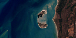
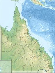
Crab Island Landsat-Bild von Crab Island westlich der Kap-York-Halbinsel Gewässer Pazifischer Ozean Inselgruppe Torres-Strait-Inseln Geographische Lage 10° 58′ 40″ S, 142° 6′ 20″ O-10.977844444444142.105425Koordinaten: 10° 58′ 40″ S, 142° 6′ 20″ O Länge 3,5 km Breite 1,5 km Fläche 2,62 km² Einwohner (unbewohnt) Crab Island, auch Moent Island genannt, ist eine australische Insel im äußersten Südwesten der Torres-Strait-Inseln. Sie liegt 1,4 km vor Slade Point, einem Kap an der Nordwestküste der Kap-York-Halbinsel.
Die Insel besteht aus zwei annäherend gleich großen Halbinseln, die durch eine nur 100 Meter breite und 580 Meter lange Nehrung miteinander verbunden sind. Die Form der Doppelinsel erinnert an eine zur Küste geöffnete Krebsschere.
Die Insel ist das wichtigste Brutgebiet der Wallriffschildkröte. Außerdem sind die Echte Karettschildkröte und die Oliv-Bastardschildkröte anzutreffen.
Verwaltungstechnisch gehört die unbewohnte Insel zu den Inner Islands, einer Inselregion im Verwaltungsbezirk Torres Shire von Queensland.
Inselregionen, Hauptinseln und Inselgruppen im Archipel der Torres-Strait-Inselnzu Papua-Neuguinea gehörige Torres-Strait-Inseln: Bristow Island | Daru Island | Parama Island • Kawai-Inseln | Talbot-Inseln
Top Western: Boigu | Dauan | Deliverance | Saibai | Turnagain • Talbot-Inseln
Western: Badu | Mabuiag | Moa | Portlock | Tobin • Bellevue-Inseln | Duncan-Inseln | Farewell-Inseln | Kulbi-Inseln
Central: Aureed | Bourke | Coconut | Sassie | Sue | Yam | Yorke • Bourke-Inseln | The Three Sisters | Yorke-Inseln
Eastern: Bramble | Darnley | Murray | Stephens • Murray-Inseln
Inner: Albany | Booby | Crab | Entrance | Friday | Goods | Hammond | Horn | Packe | Port Lihou | Prince-of-Wales | Thursday | Wednesday • Manar-Inseln | Red-Wallis-Inseln | Thursday-Inseln | Tuesday-Inseln
Wikimedia Foundation.
Schlagen Sie auch in anderen Wörterbüchern nach:
Crab Island — ist der Name mehrerer Inseln in den Vereinigten Staaten: Crab Island (Connecticut) Crab Island (Florida) Crab Island (Georgia) Crab Island (Kalifornien) Crab Island (Maine) Crab Island (Maryland) Crab Island (Michigan) Crab Island (New Jersey)… … Deutsch Wikipedia
Stephens Island (Torres Strait) — Stephens Island (Ugar) Landsat Bild der Insel mit dem wesentlich größeren umgebenden Korallenriff … Deutsch Wikipedia
Friday Island (Torres Strait) — Friday Island Landsat Bild von Friday Island Gewässer Pazifischer Ozea … Deutsch Wikipedia
Horn Island (Torres Strait) — Horn Island Landsat Bild von Horn Island (Bildmitte) Gewässer Pa … Deutsch Wikipedia
Bourke Island (Torres Strait) — w1 Bourke Island Landsat Bild von Bourke Island Gewässer … Deutsch Wikipedia
Crab Island (Queensland) — Crab Island (Moent Island) is an uninhabited island west of Muttee Heads and the coastal community of Seisia which is adjacent to Bamaga at the tip of Cape York Peninsula within the Endeavour Strait Queensland, Australia in the Torres Strait. It… … Wikipedia
Torres-Strait-Inseln — Karte der Inseln Gewässer Torres Strait (Pazifischer Ozean) … Deutsch Wikipedia
Crab Island — may refer to: Crab Island, Guyana, is at the mouth of the Berbice River Crab Island (Queensland), is in the western Torres Strait Crab Island (West Virginia), lies on the Ohio River Crab Island (Lake Champlain) near Plattsburgh, New York Crab… … Wikipedia
Liste von Torres-Strait-Inseln — Karte der Torres Strait Inseln Die Torres Strait Inseln sind eine Gruppe von 274 kleinen Inseln in der Meerespassage (Torres Straße) zwischen der Nordspitze Australiens, dem Kap York, und Papua Neuguinea. Die überwiegende Anzahl der Inseln gehört … Deutsch Wikipedia
List of Torres Strait Islands — Map of all coordinates from Google Map of all coordinates from Bing Export all coordinates as KML … Wikipedia


