- Retonfey
-
Retonfey 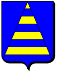
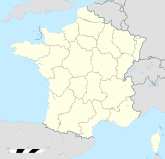

Region Lothringen Département Moselle Arrondissement Metz-Campagne Kanton Pange Koordinaten 49° 8′ N, 6° 18′ O49.1361111111116.3052777777778255Koordinaten: 49° 8′ N, 6° 18′ O Höhe 255 m (215–286 m) Fläche 9,77 km² Einwohner 1.322 (1. Jan. 2008) Bevölkerungsdichte 135 Einw./km² Postleitzahl 57645 INSEE-Code 57575 Retonfey ist eine französische Gemeinde, die im Département Moselle und in der Region Lothringen liegt. Sie gehört zum Arrondissement Metz-Campagne und zum Kanton Pange. Der Ort hat 1322 Einwohner (Stand 1. Januar 2008).
Inhaltsverzeichnis
Geografie
Retonfey liegt ein paar Kilometer östlich von Metz auf einer Höhe zwischen 215 und 286 m über dem Meeresspiegel. Das Gemeindegebiet umfasst 9,77 km².
Geschichte
1915–18 und 1940–44 trug der Ort den verdeutschten Namen Raitenbuchen.
Bevölkerungsentwicklung
Jahr 1962 1968 1975 1982 1990 1999 2007 Einwohner 307 332 718 1171 1233 1372 1313 Weblinks
Ancerville | Ars-Laquenexy | Aube | Bazoncourt | Béchy | Beux | Chanville | Coincy | Colligny | Courcelles-Chaussy | Courcelles-sur-Nied | Flocourt | Laquenexy | Lemud | Luppy | Maizeroy | Maizery | Marsilly | Montoy-Flanville | Ogy | Pange | Raville | Rémilly | Retonfey | Sanry-sur-Nied | Servigny-lès-Raville | Silly-sur-Nied | Sorbey | Thimonville | Tragny | Villers-Stoncourt
Wikimedia Foundation.
Schlagen Sie auch in anderen Wörterbüchern nach:
Retonfey — is a village and commune in the Moselle département of north eastern France.ee also*Communes of the Moselle department … Wikipedia
Retonféy — Retonféy, Dorf im deutschen Bezirk Lothringen, Landkreis Metz, hat eine kath. Kirche, ein Denkmal des 1. preußischen Armeekorps auf dem Schlachtfelde vom 14. Aug. 1870 und 300 Einw … Meyers Großes Konversations-Lexikon
Retonféy — (spr. ongfeïh), Gemeinde in Lothringen, (1900) 333 E.; danach wird von den Franzosen meist die Schlacht bei Noisseville (s.d.) genannt … Kleines Konversations-Lexikon
Retonfey — 49° 08′ 13″ N 6° 18′ 21″ E / 49.1369, 6.3058 … Wikipédia en Français
Retonfey — Original name in latin Retonfey Name in other language Retonfey State code FR Continent/City Europe/Paris longitude 49.13487 latitude 6.30749 altitude 243 Population 1404 Date 2012 01 18 … Cities with a population over 1000 database
Noisseville — 49° 08′ 07″ N 6° 16′ 28″ E / 49.1352777778, 6.27444444444 … Wikipédia en Français
Coincy (Moselle) — Cet article concerne la commune de Moselle. Pour la commune de l’Aisne, voir Coincy (Aisne). 49° 06′ 36″ N … Wikipédia en Français
Canton De Pange — Pour les articles homonymes, voir Pange. Canton de Pange Administration Pays France Région Lorraine Département … Wikipédia en Français
Canton de Pange — Pour les articles homonymes, voir Pange. Canton de Pange Administration Pays France Région Lorraine Dépar … Wikipédia en Français
Canton de pange — Pour les articles homonymes, voir Pange. Canton de Pange Administration Pays France Région Lorraine Département … Wikipédia en Français
Retonfey


18+
© Academic, 2000-2026
- Kontaktieren Sie uns: Unterstützung, Werbung
Wörterbücher Export, schritte mit PHP, Joomla, Drupal, WordPress, MODx.