- Sayama
-
Sayama-shi
狭山市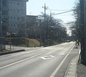
Geographische Lage in Japan 

Region: Kantō Präfektur: Saitama Koordinaten: 35° 51′ N, 139° 25′ O35.852944444444139.41221388889Koordinaten: 35° 51′ 11″ N, 139° 24′ 44″ O Basisdaten Fläche: 49,04 km² Einwohner: 155.159
(1. Juli 2011)Bevölkerungsdichte: 3.164 Einwohner je km² Gemeindeschlüssel: 11215-1 Symbole Flagge/Wappen: 
Baum: Teepflanze Baum: Azalee Vogel: Blauelster Rathaus Adresse: Sayama City Hall
1-23-5, Irumagawa
Sayama-shi
Saitama 350-1380Webadresse: http://www.city.sayama.saitama.jp Lage Sayamas in der Präfektur Saitama 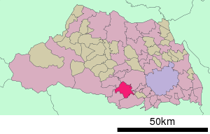
Sayama (jap. 狭山市, -shi) ist eine japanische Stadt in der Präfektur Saitama, etwa 30 Zugminuten von Tokio entfernt. Die Stadt ist berühmt für Sayama-Tee.
Inhaltsverzeichnis
Geschichte
Die Stadt Sayama entstand am 1. Juli 1954 aus dem Zusammenschluss der Gemeinde Irumagawa (入間川町, -machi) mit den Dörfern Horikane (堀兼村, -mura), Iruma (入間村, -mura), Kashiwabara (柏原村, -mura), Mizutomi (水富村, -mura) und Okutomi (奥富村, -mura) im Landkreis Iruma.
Geographie
Sayama liegt nordwestlich von Tokorozawa und südwestlich von Kawagoe.
Verkehr
- Straße:
- Nationalstraße 16, nach Chiba, Ichihara, Hachiōji und Yokosuka
- Zug:
- Seibu Shinjuku-Linie: Bahnhof Sayama, Bahnhof Inariyama-Kōen (Park)
Fabriken
Städtepartnerschaften
 Tongyeong, seit 1973
 Worthington (Ohio), seit 1999
Angrenzende Städte und Gemeinden
Weblinks
 Commons: Sayama – Sammlung von Bildern, Videos und Audiodateien
 Gemeinden und Landkreise in der Präfektur Saitama
Kreisfreie Städte (shi): Ageo | Asaka | Chichibu | Fujimi | Fujimino | Fukaya | Gyōda | Hannō | Hanyū | Hasuda | Hatogaya | Hidaka | Higashimatsuyama | Honjō | Iruma | Kasukabe | Kawagoe | Kawaguchi | Kazo | Kitamoto | Koshigaya | Kōnosu | Kuki | Kumagaya | Misato | Niiza | Okegawa | Saitama (Verwaltungssitz) | Sakado | Satte | Sayama | Shiki | Sōka | Toda | Tokorozawa | Tsurugashima | Wakō | Warabi | Yashio | Yoshikawa
Chichibu-gun: Higashichichibu | Minano | Nagatoro | Ogano | Yokoze | Hiki-gun: Hatoyama | Kawajima | Namegawa | Ogawa | Ranzan | Tokigawa | Yoshimi | Iruma-gun: Miyoshi | Moroyama | Ogose | Kitaadachi-gun: Ina | Kitakatsushika-gun: Matsubushi | Sugito | Kodama-gun: Kamikawa | Kamisato | Misato | Minamisaitama-gun: Miyashiro | Shiraoka | Ōsato-gun: Yorii
Wikimedia Foundation.
Schlagen Sie auch in anderen Wörterbüchern nach:
Sayama — shi (狭山市) Entrée sud de la gare Shin Sayama Administration Pays Japon Région Kantō … Wikipédia en Français
sayama — (Ec.) f. Cierta *serpiente. * * * sayama. f. Ecuad. Especie de culebra … Enciclopedia Universal
sayama — f. Ecuad. Especie de culebra … Diccionario de la lengua española
Sayama — Original name in latin Sayama Name in other language Irumagawa, Sajama, Sayama, sayama si, xia shan shi, Саяма State code JP Continent/City Asia/Tokyo longitude 35.85295 latitude 139.41212 altitude 81 Population 160843 Date 2010 01 29 … Cities with a population over 1000 database
Sayama, Saitama — Japanese city Name = Sayama JapaneseName=狭山市 Prefecture=Saitama Region=Kantō Area km2=49.04 Population=160,917 PopDate=2003 Density km2=3281 Coords= LatitudeDegrees= 35 LatitudeMinutes= 51 LatitudeSeconds= LongtitudeDegrees= 139 LongtitudeMinutes … Wikipedia
Sayama Tea — is a type of green tea leaves produced mainly in the southwestern region of Saitama Prefecture and a small neighboring area in Northwestern Tokyo. In comparison to teas from other tea growing regions in Japan, Sayama Tea is characterized with its … Wikipedia
Sayama Incident — The nihongo|Sayama Incident|狭山事件 is a murder case named after Sayama City, Saitama Prefecure, Japan, where it took place. The incident, in which a man was imprisoned for 31 years, highlighted official discrimination against Japan s Burakumin or… … Wikipedia
Sayama Domain — The nihongo|Sayama Domain|狭山藩|Sayama han was a Japanese domain of the Edo period, located in Kawachi Province, and headquartered in what is now Sayama, Osaka. It was ruled for the entirety of its history by the Hōjō clan, a branch of the Late… … Wikipedia
Sayama-shi — Admin ASC 2 Code Orig. name Sayama shi Country and Admin Code JP.34.1852833 JP … World countries Adminstrative division ASC I-II
Sayama Station — is a train station in Osakasayama, Osaka Prefecture, Japan.Lines*Nankai Electric Railway **Kōya LineLayoutAdjacent stations###@@@KEYEND@@@### … Wikipedia
- Straße:
Sayama


18+
© Academic, 2000-2026
- Kontaktieren Sie uns: Unterstützung, Werbung
Wörterbücher Export, schritte mit PHP, Joomla, Drupal, WordPress, MODx.