- Warabi
-
Warabi-shi
蕨市

Geographische Lage in Japan Region: Kantō Präfektur: Saitama Koordinaten: 35° 50′ N, 139° 41′ O35.825555555556139.67972222222Koordinaten: 35° 49′ 32″ N, 139° 40′ 47″ O Basisdaten Fläche: 5,10 km² Einwohner: 72.028
(1. Juli 2011)Bevölkerungsdichte: 14.123 Einwohner je km² Gemeindeschlüssel: 11223-2 Symbole Flagge/Wappen: 
Baum: Japanische Zelkove Blume: Rhododendron indicum Wiesenblume: Catharanthus roseus Rathaus Adresse: Warabi City Hall
5-14-15, Chūō
Warabi-shi
Saitama 335-8501Webadresse: www.city.warabi.saitama.jp Lage Warabis in der Präfektur Saitama 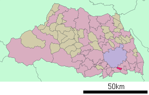
Warabi (jap. 蕨市, -shi) ist eine Stadt in der Präfektur Saitama, am nördlichen Rand der japanischen Hauptstadt Tokio gelegen.
Warabi war Gastgeber der japanischen Wushu-Meisterschaften und ist eine der wenigen japanischen Städte mit einer langen Wushu-Tradition.
Inhaltsverzeichnis
Geschichte
Warabi wurde am 1. April 1959 gegründet.
Verkehr
- Straße:
- Nationalstraße 17, nach Tōkyō oder Niigata
- Nakasendō
- Zug:
- JR Keihin-Tōhoku-Linie, Bahnhof Warabi nach Ōmiya oder Yokohama
Städtepartnerschaften
Seit 2002 besteht eine Städtepartnerschaft mit der deutschen Kleinstadt Linden.
Söhne und Töchter der Stadt
- Kotaro Suzuki (* 1978), Wrestler
- Yana Toboso (* 1984), Mangaka
Angrenzende Städte und Gemeinden
Weblinks

Kreisfreie Städte (shi): Ageo | Asaka | Chichibu | Fujimi | Fujimino | Fukaya | Gyōda | Hannō | Hanyū | Hasuda | Hatogaya | Hidaka | Higashimatsuyama | Honjō | Iruma | Kasukabe | Kawagoe | Kawaguchi | Kazo | Kitamoto | Koshigaya | Kōnosu | Kuki | Kumagaya | Misato | Niiza | Okegawa | Saitama (Verwaltungssitz) | Sakado | Satte | Sayama | Shiki | Sōka | Toda | Tokorozawa | Tsurugashima | Wakō | Warabi | Yashio | Yoshikawa
Chichibu-gun: Higashichichibu | Minano | Nagatoro | Ogano | Yokoze | Hiki-gun: Hatoyama | Kawajima | Namegawa | Ogawa | Ranzan | Tokigawa | Yoshimi | Iruma-gun: Miyoshi | Moroyama | Ogose | Kitaadachi-gun: Ina | Kitakatsushika-gun: Matsubushi | Sugito | Kodama-gun: Kamikawa | Kamisato | Misato | Minamisaitama-gun: Miyashiro | Shiraoka | Ōsato-gun: Yorii
- Straße:


Wikimedia Foundation.