- Upminster
-
London Borough of Havering 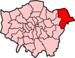
Lage in Greater LondonStatus London Borough Region Greater London Verwaltungssitz Romford Fläche 112,27 km² (231.) Einwohner (2007) 228.400 (50.) ONS-Code 00AR Website www.havering.gov.uk London Borough of Havering [ˈheɪvəɹɪŋ] ist der östlichste Stadtbezirk von London. Er entstand 1965 bei der Gründung von Greater London und wurde aus den Städten Romford und Hornchurch gebildet, die damals in der Grafschaft Essex lagen.
Havering ist der Stadtbezirk mit dem kleinsten Anteil von ethnischen Minderheiten. Die Bevölkerung setzt sich zusammen aus 95,2 % Weißen, 1,8 % Südasiaten und 1,4 % Schwarzen. Partnerstädte sind Ludwigshafen (Deutschland) und Hesdin (Frankreich).
Stadtteile
- Ardleigh Green
- Chase Cross
- Collier Row
- Elm Park
- Emerson Park
- Gidea Park
- Harold Hill
- Harold Wood
- Havering-atte-Bower
- Hornchurch
- North Ockendon
- Rainham
- Romford
- Upminster
- Wennington
Persönlichkeiten
- Tony Adams - Fußballspieler
- Glen Berry - Schauspieler
- Graham Bond - Jazz- und Blues-Musiker
- Ian Dury - Musiker und Schauspieler
- Johnny Herbert - Formel 1-Rennfahrer
- Frank Lampard - Fußballnationalspieler
- Ireen Sheer - Sängerin
- Thomas Blood - Colonel und Abenteurer
- Joe Cole - Fußballnationalspieler
- Nicky Shorey - Fußballnationalspieler
- Jo O'Meara - Sängerin (S Club 7)
- Nick Frost - Schauspieler
- Ray Parlour - ehem. Fußballnationalspieler
- Cliff Williams - Bassist der Rockgruppe AC/DC
Weblinks
Stadtbezirke von LondonBarking and Dagenham | Barnet | Bexley | Brent | Bromley | Camden | City of London | City of Westminster | Croydon | Ealing | Enfield | Greenwich | Hackney | Hammersmith and Fulham | Haringey | Harrow | Havering | Hillingdon | Hounslow | Islington | Kensington and Chelsea | Kingston | Lambeth | Lewisham | Merton | Newham | Redbridge | Richmond | Southwark | Sutton | Tower Hamlets | Waltham Forest | Wandsworth
Sonstige Einteilung: Greater London | Inner London | Outer London | County of London

Wikimedia Foundation.