- Wayne County (Pennsylvania)
-
Verwaltung US-Bundesstaat: Pennsylvania Verwaltungssitz: Honesdale Adresse des
Verwaltungssitzes:Wayne County Courthouse
925 Court Street
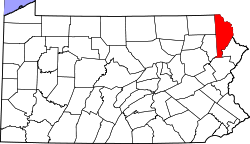
Honesdale PA 18431Gründung: 21. März 1798 Gebildet aus: Northampton County Vorwahl: 001 570 Demographie Einwohner: 47.722 (2000) Bevölkerungsdichte: 25,3 Einwohner/km² Geographie Fläche gesamt: 1.944 km² Wasserfläche: 55 km² Karte Website: www.co.wayne.pa.us Wayne County[1] ist ein County im Bundesstaat Pennsylvania der Vereinigten Staaten von Amerika. Bei der Volkszählung im Jahr 2000 hatte das County 47.722 Einwohner und eine Bevölkerungsdichte von 25 Einwohnern pro Quadratkilometer. Der Verwaltungssitz (County Seat) ist Honesdale.
Inhaltsverzeichnis
Geschichte
Das County wurde am 21. März 1798 aus Northampton County gebildet und nach Anthony Wayne benannt.
Geografie
Das County hat eine Fläche von 1.944 Quadratkilometern, wovon 55 Quadratkilometer Wasserfläche sind.
Bevölkerungsentwicklung
Historische Einwohnerzahlen Census Einwohner ± in % 1900 30.171 — 1910 29.236 -3 % 1920 27.435 -6 % 1930 28.420 4 % 1940 29.934 5 % 1950 28.478 -5 % 1960 28.237 -0,8 % 1970 29.581 5 % 1980 35.237 20 % 1990 39.944 10 % 2000 47.718 20 % 1900–1990[2] 2000[3]
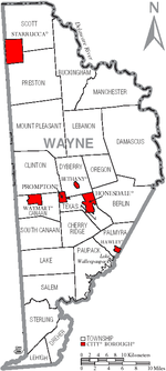
Städte und Ortschaften
- Berlin Township
- Bethany
- Buckingham Township
- Canaan Township
- Cherry Ridge Township
- Clinton Township
- Damascus Township
- Dreher Township
- Dyberry Township
- Hawley
- Honesdale
- Lake Township
- Lebanon Township
- Lehigh Township
- Manchester Township
- Mount Pleasant Township
- Oregon Township
- Palmyra Township
- Paupack Township
- Preston Township
- Prompton
- Salem Township
- Scott Township
- South Canaan Township
- Starrucca
- Sterling Township
- Texas Township
- Waymart
Einzelnachweise
- ↑ Wayne County im Geographic Names Information System des United States Geological Survey. Abgerufen am 22. Februar 2011
- ↑ Auszug aus Census.gov. Abgerufen am 28. Februar 2011
- ↑ Auszug aus factfinder.census.gov Abgerufen am 28. Februar 2011
41.65-75.31Koordinaten: 41° 39′ N, 75° 19′ WListe der Countys in Pennsylvania
Adams | Allegheny | Armstrong | Beaver | Bedford | Berks | Blair | Bradford | Bucks | Butler | Cambria | Cameron | Carbon | Centre | Chester | Clarion | Clearfield | Clinton | Columbia | Crawford | Cumberland | Dauphin | Delaware | Elk | Erie | Fayette | Forest | Franklin | Fulton | Greene | Huntingdon | Indiana | Jefferson | Juniata | Lackawanna | Lancaster | Lawrence | Lebanon | Lehigh | Luzerne | Lycoming | McKean | Mercer | Mifflin | Monroe | Montgomery | Montour | Northampton | Northumberland | Perry | Philadelphia | Pike | Potter | Schuylkill | Snyder | Somerset | Sullivan | Susquehanna | Tioga | Union | Venango | Warren | Washington | Wayne | Westmoreland | Wyoming | York
Wikimedia Foundation.
Schlagen Sie auch in anderen Wörterbüchern nach:
Wayne County, Pennsylvania — Infobox U.S. County county = Wayne County state = Pennsylvania map size = 225 founded = March 21, 1798 seat = Honesdale | largest city = Honesdale area total sq mi =751 area water sq mi =21 area percentage = 2.84% census yr = 2000 pop = 47722… … Wikipedia
National Register of Historic Places listings in Wayne County, Pennsylvania — Location of Wayne County in Pennsylvania This is a list of the National Register of Historic Places listings in Wayne County, Pennsylvania. This is intended to be a complete list of the properties and districts on the National Register of… … Wikipedia
Clinton Township, Wayne County, Pennsylvania — For other Pennsylvania townships of the same name, see Clinton Township, Pennsylvania (disambiguation). Coordinates: 41°39′00″N 75°24′59″W / 41.65°N 75.41639°W … Wikipedia
Manchester Township, Wayne County, Pennsylvania — For other townships in Pennsylvania with similar names, see Manchester Township, Pennsylvania. Coordinates: 41°48′00″N 75°06′59″W / 41.8°N 75.11639°W … Wikipedia
Mount Pleasant Township, Wayne County, Pennsylvania — For other Pennsylvania townships of the same name, see Mount Pleasant Township, Pennsylvania. Coordinates: 41°43′00″N 75°24′59″W / 41.7166667°N 75.41639°W … Wikipedia
Cherry Ridge Township, Wayne County, Pennsylvania — Coordinates: 41°29′00″N 75°18′59″W / 41.4833333°N 75.31639°W / 41.4833333; 75.31639 … Wikipedia
Damascus Township, Wayne County, Pennsylvania — Coordinates: 41°37′00″N 75°06′59″W / 41.6166667°N 75.11639°W / 41.6166667; 75.11639 … Wikipedia
Dreher Township, Wayne County, Pennsylvania — Coordinates: 41°17′00″N 75°22′35″W / 41.2833333°N 75.37639°W / 41.2833333; 75.37639 … Wikipedia
Dyberry Township, Wayne County, Pennsylvania — Coordinates: 41°36′00″N 75°14′53″W / 41.6°N 75.24806°W / 41.6; 75.24806 … Wikipedia
Oregon Township, Wayne County, Pennsylvania — Coordinates: 41°37′00″N 75°12′59″W / 41.6166667°N 75.21639°W / 41.6166667; 75.21639 … Wikipedia


