- Westmoreland County (Pennsylvania)
-
Verwaltung US-Bundesstaat: Pennsylvania Verwaltungssitz: Greensburg Gründung: 26. Februar 1773 Gebildet aus: Bedford County Vorwahl: 001 724 Demographie Einwohner: 365.169 (2010) Bevölkerungsdichte: 137,5 Einwohner/km² Geographie Fläche gesamt: 2.684 km² Wasserfläche: 28 km² Karte 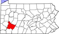
Website: www.co.westmoreland.pa.us
Das Westmoreland County[2] ist ein County im US-amerikanischen Bundesstaat Pennsylvania. Bei der Volkszählung im Jahr 2010 hatte das County 365.169 Einwohner und eine Bevölkerungsdichte von 137,5 Einwohnern pro Quadratkilometer. Der Verwaltungssitz (County Seat) ist Greensburg.Das Westmoreland County ist Bestandteil der Metropolregion um die Stadt Pittsburgh.
Inhaltsverzeichnis
Geografie
Das County liegt im Südwesten von Pennsylvania am Monongahela River und dem Allegheny River, den beiden Quellflüssen des Ohio River. Das Westmoreland hat eine Fläche von 2.684 Quadratkilometern, wovon 28 Quadratkilometer Wasserfläche sind. Es grenzt an folgende Countys:
Butler County Armstrong County Indiana County Allegheny County 
Cambria County Washington County Fayette County Somerset County Geschichte
Das County wurde am 26. Februar 1773 aus ehemaligen Teilen des Bedford County gegründet. Benannt wurde es nach der traditionellen englischen Grafschaft Westmorland.
Historische Gebäude
Im Washington Township des Export Borough, steht das historische Gehöft John Walter Farmstead. Das Anwesen wurde am 21. Juli 1995 vom National Register of Historic Places mit der Nummer 95000885 aufgenommen.[3]
Demografische Daten
Historische Einwohnerzahlen Census Einwohner ± in % 1790 16.019 — 1800 22.726 40 % 1810 26.392 20 % 1820 30.540 20 % 1830 38.400 30 % 1840 42.699 10 % 1850 51.726 20 % 1860 53.736 4 % 1870 58.719 9 % 1880 78.036 30 % 1890 112.819 40 % 1900 160.175 40 % 1910 231.304 40 % 1920 273.568 20 % 1930 294.995 8 % 1940 303.411 3 % 1950 313.179 3 % 1960 352.629 10 % 1970 376.935 7 % 1980 392.294 4 % 1990 370.321 -6 % 2000 369.993 -0,09 % 2010 365.169 -1 % vor 1900[4] 1900–1990[5] 2000[6] 2010[7] 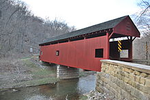 Die im NRHP gelistete Longdon L. Miller Covered Bridge im Westmoreland County
Nach der Volkszählung im Jahr 2010 lebten im Westmoreland County 365.169 Menschen in 151.936 Haushalten. Die Bevölkerungsdichte betrug 137,5 Einwohner pro Quadratkilometer.
Ethnisch betrachtet setzte sich die Bevölkerung zusammen aus 95,3 Prozent Weißen, 2,3 Prozent Afroamerikanern, 0,1 Prozent amerikanischen Ureinwohnern, 0,7 Prozent Asiaten sowie aus anderen ethnischen Gruppen; 1,2 Prozent stammten von zwei oder mehr Ethnien ab. Unabhängig von der ethnischen Zugehörigkeit waren 0,9 Prozent der Bevölkerung spanischer oder lateinamerikanischer Abstammung.
In den 151.936 Haushalten lebten statistisch je 2,32 Personen.
19,9 Prozent der Bevölkerung waren unter 18 Jahre alt, 61,2 Prozent waren zwischen 18 und 64 und 18,9 Prozent waren 65 Jahre oder älter. 51,3 Prozent der Bevölkerung war weiblich.
Das jährliche Durchschnittseinkommen eines Haushalts lag bei 47.312 USD. Das Pro - Kopf - Einkommen betrug 25.344 USD. 10,4 Prozent der Einwohner lebten unterhalb der Armutsgrenze.[8]
Städte und Gemeinden
 Karte des Westmoreland Countys
- Arnold
- Greensburg
- Jeannette
- Latrobe
- Lower Burrell
- Monessen
- New Kensington
- Adamsburg
- Arona
- Avonmore
- Bolivar
- Delmont
- Derry
- Donegal
- East Vandergrift
- Export
- Hunker
- Hyde Park
- Irwin
- Laurel Mountain
- Ligonier
- Madison
- Manor
- Mount Pleasant
- Murrysville
- New Alexandria
- New Florence
- New Stanton
- North Belle Vernon
- North Irwin
- Oklahoma
- Penn
- Scottdale
- Seward
- Smithton
- South Greensburg
- Southwest Greensburg
- Sutersville
- Trafford1
- Vandergrift
- West Leechburg
- West Newton
- Youngstown
- Youngwood
Census-designated places (CDP)
- Crabtree
- Grapeville
- Harrison City
- Herminie
- Lawson Heights
- Slickville
- Acme2
- Boquet
- Calumet
- Hannastown
- Hopewell
- Hutchinson
- Kecksburg
- Lloydsville
- Luxor
- Moween
- Norvelt
- Ruffs Dale
- Southwest
- Stahlstown
- Standard Shaft
- Salina
- Turkeytown
- United
1 - teilweise im Allegheny County
2 - teilweise im Fayette CountyTownships
- Allegheny Township
- Bell Township
- Cook Township
- Derry Township
- Donegal Township
- East Huntingdon Township
- Fairfield Township
- Hempfield Township
- Ligonier Townshipp
- Loyalhanna Township
- Mount Pleasant Township
- North Huntingdon Township
- Penn Township
- Rostraver Township
- Salem Township
- Sewickley Township
- South Huntingdon Township
- St. Clair Township
- Unity Township
- Upper Burrell Township
- Washington Township
Einzelnachweise
- ↑ Auszug aus dem National Register of Historic Places - Nr. 78002485 Abgerufen am 28. Oktober 2011
- ↑ Westmoreland County im Geographic Names Information System des United States Geological Survey. Abgerufen am 22. Februar 2011
- ↑ NRIS
- ↑ University of Virginia Library - Historical Census Browser Abgerufen am 28. Oktober 2011
- ↑ Auszug aus Census.gov Abgerufen am 28. Februar 2011
- ↑ Auszug aus factfinder.census.gov Abgerufen am 28. Februar 2011
- ↑ United States Census 2010 Abgerufen am 28. Oktober 2011
- ↑ U.S. Census Buero, State & County QuickFacts - Westmoreland County Abgerufen am 28. Oktober 2011
Weblinks
-
 Commons: Westmoreland County, Pennsylvania – Sammlung von Bildern, Videos und Audiodateien
 - Offizielle Webseite
- U.S. Census Buero, State & County QuickFacts - Westmoreland County
- Yahoo Bildersuche - Westmoreland County
- www.city-data.com - Westmoreland County

Liste der Countys in Pennsylvania
Adams | Allegheny | Armstrong | Beaver | Bedford | Berks | Blair | Bradford | Bucks | Butler | Cambria | Cameron | Carbon | Centre | Chester | Clarion | Clearfield | Clinton | Columbia | Crawford | Cumberland | Dauphin | Delaware | Elk | Erie | Fayette | Forest | Franklin | Fulton | Greene | Huntingdon | Indiana | Jefferson | Juniata | Lackawanna | Lancaster | Lawrence | Lebanon | Lehigh | Luzerne | Lycoming | McKean | Mercer | Mifflin | Monroe | Montgomery | Montour | Northampton | Northumberland | Perry | Philadelphia | Pike | Potter | Schuylkill | Snyder | Somerset | Sullivan | Susquehanna | Tioga | Union | Venango | Warren | Washington | Wayne | Westmoreland | Wyoming | York
Wikimedia Foundation.
Schlagen Sie auch in anderen Wörterbüchern nach:
Westmoreland County, Pennsylvania — Infobox U.S. County county = Westmoreland County state = Pennsylvania map size = 225 founded = February 26, 1773 seat = Greensburg | largest city = Greensburg area total sq mi =1036 area land sq mi =1025 area water sq mi =11 area percentage =… … Wikipedia
National Register of Historic Places listings in Westmoreland County, Pennsylvania — Location of Westmoreland County This is a list of the National Register of Historic Places listings in Westmoreland County, Pennsylvania. This is intended to be a complete list of the properties and districts on the National Register of Historic… … Wikipedia
North Huntingdon Township, Westmoreland County, Pennsylvania — For other places in Pennsylvania with similar names, see Huntingdon, Pennsylvania (disambiguation). North Huntingdon Township, Pennsylvania Township … Wikipedia
Derry Township, Westmoreland County, Pennsylvania — For other Pennsylvania townships of the same name, see Derry Township, Pennsylvania (disambiguation). Derry Township, Westmoreland County, Pennsylvania Township … Wikipedia
Donegal Township, Westmoreland County, Pennsylvania — For other Pennsylvania townships of the same name, see Donegal Township, Pennsylvania (disambiguation). There is also a Borough of Donegal in Pennsylvania. Donegal Township, Westmoreland County, Pennsylvania Township … Wikipedia
Mount Pleasant Township, Westmoreland County, Pennsylvania — For other Pennsylvania townships of the same name, see Mount Pleasant Township, Pennsylvania. Mount Pleasant Township, Westmoreland County, Pennsylvania Township … Wikipedia
Cook Township, Westmoreland County, Pennsylvania — Not to be confused with Cooke Township, Cumberland County, Pennsylvania. Cook Township, Pennsylvania Township … Wikipedia
Hempfield Township, Westmoreland County, Pennsylvania — Infobox Settlement official name = Hempfield Township, Westmoreland County, Pennsylvania settlement type = Township nickname = motto = imagesize = image caption = image mapsize = 250x200px map caption = Map of Westmoreland County, Pennsylvania… … Wikipedia
Allegheny Township, Westmoreland County, Pennsylvania — Infobox Settlement official name = Allegheny Township, Westmoreland County, Pennsylvania settlement type = Township nickname = motto = imagesize = image caption = image mapsize = 250x200px map caption = Map of Westmoreland County, Pennsylvania… … Wikipedia
Bell Township, Westmoreland County, Pennsylvania — Infobox Settlement official name = Bell Township, Westmoreland County, Pennsylvania settlement type = Township nickname = motto = imagesize = image caption = image mapsize = 250x200px map caption = Map of Westmoreland County, Pennsylvania… … Wikipedia
Westmoreland County (Pennsylvania)


18+
© Academic, 2000-2026
- Kontaktieren Sie uns: Unterstützung, Werbung
Wörterbücher Export, schritte mit PHP, Joomla, Drupal, WordPress, MODx.