- Lehigh County
-
Verwaltung US-Bundesstaat: Pennsylvania Verwaltungssitz: Allentown Adresse des
Verwaltungssitzes:Lehigh County Government
17 S. Seventh St.
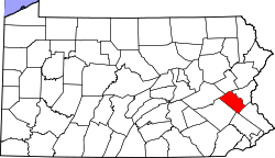
Allentown, PA 18101Gründung: 6. März 1812 Gebildet aus: Northampton County Vorwahl: 001 610 Demographie Einwohner: 312.090 (2000) Bevölkerungsdichte: 347,5 Einwohner/km² Geographie Fläche gesamt: 902 km² Wasserfläche: 4 km² Karte Website: www.lehighcounty.org Lehigh County[1] ist ein County im Bundesstaat Pennsylvania der Vereinigten Staaten von Amerika. Bei der Volkszählung im Jahr 2000 hatte das County 312.090 Einwohner und eine Bevölkerungsdichte von 348 Einwohner pro Quadratkilometer. Der Verwaltungssitz (County Seat) ist Allentown.
Inhaltsverzeichnis
Geografie
Das County hat eine Fläche von 902 Quadratkilometern, wovon 4 Quadratkilometer Wasserfläche sind.
Bevölkerungsentwicklung
Historische Einwohnerzahlen Census Einwohner ± in % 1900 93.893 — 1910 118.832 30 % 1920 148.101 20 % 1930 172.893 20 % 1940 177.533 3 % 1950 198.207 10 % 1960 227.536 10 % 1970 255.304 10 % 1980 272.349 7 % 1990 291.130 7 % 2000 312.090 7 % 1900–1990[2] 2000[3]
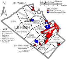
Städte und Ortschaften
- Hanover Township
- Heidelberg Township
- Hokendauqua
- Lower Macungie Township
- Lower Milford Township
- Lowhill Township
- Lynn Township
- Macungie
- North Whitehall Township
- Salisbury Township
- Schnecksville
- Slatington
- South Whitehall Township
- Upper Macungie Township
- Upper Milford Township
- Upper Saucon Township
- Washington Township
- Weisenberg Township
- Whitehall Township
Einzelnachweise
- ↑ Lehigh County im Geographic Names Information System des United States Geological Survey. Abgerufen am 22. Februar 2011
- ↑ Auszug aus Census.gov. Abgerufen am 28. Februar 2011
- ↑ Auszug aus factfinder.census.gov Abgerufen am 28. Februar 2011
Liste der Countys in Pennsylvania
Adams | Allegheny | Armstrong | Beaver | Bedford | Berks | Blair | Bradford | Bucks | Butler | Cambria | Cameron | Carbon | Centre | Chester | Clarion | Clearfield | Clinton | Columbia | Crawford | Cumberland | Dauphin | Delaware | Elk | Erie | Fayette | Forest | Franklin | Fulton | Greene | Huntingdon | Indiana | Jefferson | Juniata | Lackawanna | Lancaster | Lawrence | Lebanon | Lehigh | Luzerne | Lycoming | McKean | Mercer | Mifflin | Monroe | Montgomery | Montour | Northampton | Northumberland | Perry | Philadelphia | Pike | Potter | Schuylkill | Snyder | Somerset | Sullivan | Susquehanna | Tioga | Union | Venango | Warren | Washington | Wayne | Westmoreland | Wyoming | York
Wikimedia Foundation.
Schlagen Sie auch in anderen Wörterbüchern nach:
Lehigh County — Admin ASC 2 Code Orig. name Lehigh County Country and Admin Code US.PA.077 US … World countries Adminstrative division ASC I-II
Lehigh County, Pennsylvania — Infobox U.S. County county = Lehigh County state = Pennsylvania map size = 225 founded = March 6, 1812 seat = Allentown | largest city = Allentown area total sq mi =349 area land sq mi =347 area water sq mi =2 area percentage = 0.48% census yr =… … Wikipedia
Lehigh County Historical Society — Infobox Museum name = Lehigh County Historical Society imagesize = 200 map type = latitude = 40.60219 longitude = 75.46592 established = 1904 location = 432 West Walnut Street Allentown, Pennsylvania USA type = Historical visitors = director =… … Wikipedia
National Register of Historic Places listings in Lehigh County, Pennsylvania — Location of Lehigh County in Pennsylvania This is a list of the National Register of Historic Places listings in Lehigh County, Pennsylvania. This is intended to be a complete list of the properties and districts on National Register of Historic… … Wikipedia
State Route 1002 (Lehigh County, Pennsylvania) — Infobox road state=PA type=QR route=1002 alternate name=Main Street; Tilghman Street; Union Boulevard maint= length mi=13.77 length round=2 length ref=cite web|url=http://www.mapquest.com/directions/main.adp?mo=ma 2si=navt un=m go=1 2gi=0… … Wikipedia
North Whitehall Township, Lehigh County, Pennsylvania — Not to be confused with South Whitehall Township, Lehigh County, Pennsylvania, Whitehall Township, Lehigh County, Pennsylvania, or Whitehall, Allegheny County, Pennsylvania. Coordinates: 40°37′27″N 75°37′25″W / … Wikipedia
Newtown, Lehigh County, Pennsylvania — Not to be confused with Newtown, Bucks County, Pennsylvania. Newtown, Lehigh County, Pennsylvania is a village in Upper Macungie Township located a short distance north of U.S. Route 222. It is drained by Schaefer Run into the Little Lehigh Creek … Wikipedia
Hanover Township, Lehigh County, Pennsylvania — Geobox Township name = Hanover Township native name = other name = other name1 = category = Township image size = image caption = flag size = symbol = symbol size = nickname = motto = country = United States state = Pennsylvania region = Lehigh… … Wikipedia
Salisbury Township, Lehigh County, Pennsylvania — Geobox Township name = Salisbury Township native name = other name = other name1 = category = Township image size = image caption = flag size = symbol = symbol size = nickname = motto = country = United States state = Pennsylvania region = Lehigh … Wikipedia
Heidelberg Township, Lehigh County, Pennsylvania — Geobox Township name = Heidelberg Township native name = other name = other name1 = category = Township image size = image caption = flag size = symbol = symbol size = nickname = motto = country = United States state = Pennsylvania region =… … Wikipedia