- Greene County (Pennsylvania)
-
Verwaltung US-Bundesstaat: Pennsylvania Verwaltungssitz: Waynesburg Adresse des
Verwaltungssitzes:93 East High Street
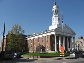
Waynesburg, PA 15370Gründung: 9. Februar 1796 Gebildet aus: Washington County Vorwahl: 001 724 Demographie Einwohner: 38.686 (2010) Bevölkerungsdichte: 25,9 Einwohner/km² Geographie Fläche gesamt: 1.497 km² Wasserfläche: 5 km² Karte Website: www.co.greene.pa.us Das Greene County[1] ist ein County im US-amerikanischen Bundesstaat Pennsylvania. Bei der Volkszählung im Jahr 2010 hatte das County 38.686 Einwohner und eine Bevölkerungsdichte von 25,9 Einwohnern pro Quadratkilometer. Der Verwaltungssitz (County Seat) ist Waynesburg.
Inhaltsverzeichnis
Geografie
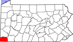
Das County liegt im äußersten Südwesten von Pennsylvania am Westufer des Monongahela River, einem der Quellflüsse des Ohio River; im Westen und Süden grenzt es an West Virginia, wobei die Südgrenze durch die Verlängerung der Mason-Dixon-Linie gebildet wird. Es hat eine Fläche von 1.497 Quadratkilometern, wovon 5 Quadratkilometer Wasserfläche sind. An das Greene County grenzen folgende Countys:
Washington County Marshall County
(West Virginia)
Fayette County Wetzel County
(West Virginia)Monongalia County
(West Virginia)Geschichte
Das Greene County wurde am 9. Februar 1796 aus dem Washington County gebildet. Benannt wurde es nach Nathanael Greene (1742-1786), einem General der Kontinentalarmee im Amerikanischen Unabhängigkeitskrieg.
Demografische Daten
Historische Einwohnerzahlen Census Einwohner ± in % 1800 8605 — 1810 12.544 50 % 1820 15.554 20 % 1830 18.028 20 % 1840 19.147 6 % 1850 22.136 20 % 1860 24.343 10 % 1870 25.887 6 % 1880 28.273 9 % 1890 28.935 2 % 1900 28.281 -2 % 1910 28.882 2 % 1920 30.804 7 % 1930 41.767 40 % 1940 44.671 7 % 1950 45.394 2 % 1960 39.457 -10 % 1970 39.108 -0,9 % 1980 42.253 8 % 1990 44.164 5 % 2000 40.672 -8 % 2010 38.686 -5 % vor 1900[2] 1900–1990[3] 2000[4] 2010[5] Nach der Volkszählung im Jahr 2010 lebten im Greene County 38.686 Menschen in 14.530 Haushalten. Die Bevölkerungsdichte betrug 25,9 Einwohner pro Quadratkilometer.
Ethnisch betrachtet setzte sich die Bevölkerung zusammen aus 94,6 Prozent Weißen, 3,3 Prozent Afroamerikanern, 0,2 Prozent amerikanischen Ureinwohnern, 0,3 Prozent Asiaten sowie aus anderen ethnischen Gruppen; 1,0 Prozent stammten von zwei oder mehr Ethnien ab. Unabhängig von der ethnischen Zugehörigkeit waren 1,2 Prozent der Bevölkerung spanischer oder lateinamerikanischer Abstammung.
In den 14.530 Haushalten lebten statistisch je 2,52 Personen.
19,9 Prozent der Bevölkerung waren unter 18 Jahre alt, 64,8 Prozent waren zwischen 18 und 64 und 15,3 Prozent waren 65 Jahre oder älter. 48,5 Prozent der Bevölkerung war weiblich.
Das jährliche Durchschnittseinkommen eines Haushalts lag bei 38.233 USD. Das Pro - Kopf - Einkommen betrug 19.832 USD. 17,5 Prozent der Einwohner lebten unterhalb der Armutsgrenze.[6]
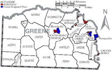
Städte und Gemeinden
- Carmichaels
- Clarksville
- Greensboro
- Jefferson
- Rices Landing
- Waynesburg
Census-designated places (CDP)
- Fairdale
- Morrisville
- Nemacolin
- Khedive
- Mount Morris
Townships
- Aleppo Township
- Center Township
- Cumberland Township
- Dunkard Township
- Franklin Township
- Freeport Township
- Gilmore Township
- Gray Township
- Greene Township
- Jackson Township
- Jefferson Township
- Monongahela Township
- Morgan Township
- Morris Township
- Perry Township
- Richhill Township
- Springhill Township
- Washington Township
- Wayne Township
- Whiteley Township
Einzelnachweise
- ↑ Greene County im Geographic Names Information System des United States Geological Survey Abgerufen am 22. Februar 2011
- ↑ University of Virginia Library - Historical Census Browser Abgerufen am 27. Oktober 2011
- ↑ Auszug aus Census.gov Abgerufen am 28. Februar 2011
- ↑ Auszug aus factfinder.census.gov Abgerufen am 28. Februar 2011
- ↑ United States Census 2010 Abgerufen am 27. Oktober 2011
- ↑ U.S. Census Buero, State & County QuickFacts - Greene County Abgerufen am 27. Oktober 2011
Weblinks
-
 Commons: Greene County, Pennsylvania – Sammlung von Bildern, Videos und Audiodateien
 - Offizielle Webseite
- U.S. Census Buero, State & County QuickFacts - Greene County
- Yahoo Bildersuche - Greene County
- www.city-data.com - Greene County
Liste der Countys in Pennsylvania
Adams | Allegheny | Armstrong | Beaver | Bedford | Berks | Blair | Bradford | Bucks | Butler | Cambria | Cameron | Carbon | Centre | Chester | Clarion | Clearfield | Clinton | Columbia | Crawford | Cumberland | Dauphin | Delaware | Elk | Erie | Fayette | Forest | Franklin | Fulton | Greene | Huntingdon | Indiana | Jefferson | Juniata | Lackawanna | Lancaster | Lawrence | Lebanon | Lehigh | Luzerne | Lycoming | McKean | Mercer | Mifflin | Monroe | Montgomery | Montour | Northampton | Northumberland | Perry | Philadelphia | Pike | Potter | Schuylkill | Snyder | Somerset | Sullivan | Susquehanna | Tioga | Union | Venango | Warren | Washington | Wayne | Westmoreland | Wyoming | York
Wikimedia Foundation.
Schlagen Sie auch in anderen Wörterbüchern nach:
Greene County, Pennsylvania — Greene County Courthouse in Waynesburg … Wikipedia
Greene Township, Greene County, Pennsylvania — Geobox|Township name = Greene Township official name = category = Township image size = image caption = flag size = symbol = symbol size = etymology = etymology type = nickname = motto = country = United States country state = Pennsylvania state… … Wikipedia
National Register of Historic Places listings in Greene County, Pennsylvania — Location of Greene County in Pennsylvania This is a list of the National Register of Historic Places listings in Greene County, Pennsylvania. This is intended to be a complete list of the properties and districts on National Register of Historic… … Wikipedia
Cumberland Township, Greene County, Pennsylvania — For other Pennsylvania townships of the same name, see Cumberland Township, Pennsylvania (disambiguation). Cumberland Township Township Country United States … Wikipedia
Morris Township, Greene County, Pennsylvania — For other Pennsylvania townships of the same name, see Morris Township, Pennsylvania. Morris Township Township Country United States … Wikipedia
Morrisville, Greene County, Pennsylvania — Coordinates: 39°53′54″N 80°10′5″W / 39.89833°N 80.16806°W / 39.89833; 80.16806 … Wikipedia
Dunkard Township, Greene County, Pennsylvania — Dunkard Township Township Country United States State … Wikipedia
Monongahela Township, Greene County, Pennsylvania — Monongahela Township Township Country United States State … Wikipedia
Morgan Township, Greene County, Pennsylvania — Morgan Township Township Country United States State … Wikipedia
Perry Township, Greene County, Pennsylvania — Geobox|Township name = Perry Township official name = category = Township image size = image caption = flag size = symbol = symbol size = etymology = etymology type = nickname = motto = country = United States country state = Pennsylvania state… … Wikipedia


