- Benton County (Arkansas)
-
Verwaltung US-Bundesstaat: Arkansas Verwaltungssitz: Bentonville Adresse des
Verwaltungssitzes:Benton County Courthouse
215 East Central
Bentonville, AR 72712Gründung: 30. September 1836 Gebildet aus: Washington County Vorwahl: 001 479 Demographie Einwohner: 221.339 (2000) Bevölkerungsdichte: 101 Einwohner/km² Geographie Fläche gesamt: 2.280 km² Wasserfläche: 89 km² Karte 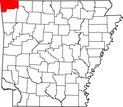
Website: www.co.benton.ar.us Das Benton County[2] ist ein County im US-amerikanischen Bundesstaat Arkansas. Bei der Volkszählung im Jahr 2010 hatte das County 221.339 Einwohner und eine Bevölkerungsdichte von 101 Einwohnern pro Quadratkilometer. Der Verwaltungssitz (County Seat) ist Bentonville. Das County gehört zu den Dry Countys, was bedeutet, dass der Verkauf von Alkohol eingeschränkt oder verboten ist.
Das Benton County ist Bestandteil der Metropolregion Fayetteville–Springdale–Rogers in Arkansas und Missouri.
Inhaltsverzeichnis
Geografie
Das County liegt im äußersten Nordwesten von Arkansas, grenzt im Norden an Missouri, im Westen an Oklahoma und hat eine Fläche von 2.280 Quadratkilometern, wovon 89 Quadratkilometer Wasserfläche sind. Es grenzt an folgende Countys:
McDonald County
(Missouri)Barry County
(Missouri)Delaware County
(Oklahoma)
Carroll County Adair County
(Oklahoma)Washington County Madison County Geschichte
 Benton
Das Benton County wurde am 30. September 1836[3] aus Teilen des Washington-County gebildet. Benannt wurde es nach Thomas Hart Benton, einem US-Senator von Missouri, nach dem auch die Stadt Bentonville benannt wurde. Während des Sezessionskrieges, 1861 bis 1865, wurde die Gegend hart umkämpft. Vom 7. bis 8. März 1862 fand hier die wohl strategisch wichtigste Schlacht westlich des Mississippis, die Schlacht am Pea Ridge statt, die zu Gunsten der Nordstaaten endete. Überall im County finden sich noch heute Monumente und Gedenktafeln für die gefallenen Soldaten der Konföderierten.
Um 1880 brachten die Eisenbahnen der St. Louis & San Francisco Railroad und der Fort Smith, & Southern Railway, später umbenannt in die Kansas City, Pittsburg and Gulf Railroad, um 1900 nochmals umbenannt in Kansas City Southern, einen erneuten Aufschwung in diese Gegend.
Nachdem mehrere bekannte Unternehmen hier gegründet wurden, verdoppelte sich die Einwohnerzahl in der Zeit von 1950 bis 1980. Bis 1990 nahm sie nochmals um 25 % zu.
Wirtschaft
Haupteinnahmequellen sind die Gewinnung von Bodenschätzen, die Landwirtschaft, der Obstanbau, Geflügel und Molkereiprodukte. Zusätzlich haben namhafte Unternehmen wie Little Debbie Bakeries, Cooper Communities, Bella Vista oder Wal-Mart, der in den Vereinigten Staaten am schnellsten wachsenden Einzelhandelskette, ihre Hauptzentrale hier, was viele Arbeitsplätze sichert.
Demografische Daten
Historische Einwohnerzahlen Census Einwohner ± in % 1840 2228 — 1850 3710 70 % 1860 9306 200 % 1870 13.831 50 % 1880 20.328 50 % 1890 27.716 40 % 1900 31.611 10 % 1910 33.389 6 % 1920 36.253 9 % 1930 35.253 -3 % 1940 36.148 3 % 1950 38.076 5 % 1960 36.272 -5 % 1970 50.476 40 % 1980 78.115 50 % 1990 97.499 20 % 2000 153.406 60 % 2010 221.339 40 % 1840-1890[4] 1900–1990[5] 2010[6] 
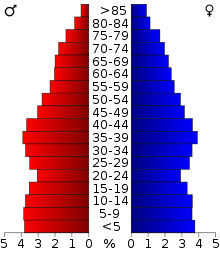 Alterspyramide des Benton County
Nach der Volkszählung im Jahr 2000 lebten im Benton County 153.406 Menschen in 58.212 Haushalten und 43.484 Familien. Die Bevölkerungsdichte betrug 70 Einwohner pro Quadratkilometer. Ethnisch betrachtet setzte sich die Bevölkerung zusammen aus 90,87 Prozent Weißen, 0,41 Prozent Afroamerikanern, 1,65 Prozent amerikanischen Ureinwohnern, 1,09 Prozent Asiaten, 0,08 Prozent Bewohnern aus dem pazifischen Inselraum und 4,08 Prozent aus anderen ethnischen Gruppen. Unabhängig von der ethnischen Zugehörigkeit waren 1,82 Prozent der Bevölkerung spanischer oder lateinamerikanischer Abstammung.
Von den 58.212 Haushalten hatten 34,4 Prozent Kinder oder Jugendliche im Alter unter 18 Jahre, die mit ihnen zusammen lebten. 63,0 Prozent waren verheiratete, zusammenlebende Paare, 8,2 Prozent waren allein erziehende Mütter, 25,3 Prozent waren keine Familien. 21,1 Prozent aller Haushalte waren Singlehaushalte und in 8,5 Prozent lebten Menschen im Alter von 65 Jahren oder darüber. Die Durchschnittshaushaltsgröße lag bei 2,60 und die durchschnittliche Familiengröße bei 3,01 Personen.
26,6 Prozent der Bevölkerung waren unter 18 Jahre alt, 8,6 Prozent zwischen 18 und 24, 29,4 Prozent zwischen 25 und 44, 21,1 Prozent zwischen 45 und 64 und 14,3 Prozent waren 65 Jahre oder älter. Das Durchschnittsalter betrug 35 Jahre. Auf 100 weibliche kamen statistisch 97,4 männliche Personen und auf 100 Frauen im Alter von 18 Jahren und darüber kamen durchschnittlich 94,9 Männer.
Das jährliche Durchschnittseinkommen eines Haushalts betrug 40.281 USD, das Durchschnittseinkommen der Familien 45.235 USD. Männer hatten ein Durchschnittseinkommen von 30.327 USD, Frauen 22.469 USD. Das Pro - Kopf - Einkommen betrug 19.377 USD. 7,3 Prozent der Familien und 10,1 Prozent der Einwohner lebten unterhalb der Armutsgrenze.[8]
Städte und Gemeinden
- Bentonville
- Bethel Heights
- Cave Springs
- Centerton
- Decatur
- Elm Springs1
- Gentry
- Gravette
- Little Flock
- Lowell
- Pea Ridge
- Rogers
- Siloam Springs
- Springdale1
- Sulphur Springs
- Avoca
- Bella Vista
- Garfield
- Gateway
- Highfill
- Springtown
Census-designated places (CDP)
- Cherokee City
- Hiwasse
- Lost Bridge Village
- Maysville
- Prairie Creek
1 - teilweise im Washington County
Einzelnachweise
- ↑ Auszug aus dem National Register of Historic Places. Abgerufen am 13. März 2011
- ↑ GNIS-ID: 69896. Abgerufen am 22. Februar 2011 (englisch).
- ↑ Auszug aus der Encyclopedia of Arkansas. Abgerufen am 12. Februar 2011
- ↑ U.S. Census Bureau _ Census of Population and Housing Abgerufen am 17. Februar 2011
- ↑ Auszug aus Census.gov Abgerufen am 15. Februar 2011
- ↑ United States Census 2010 Abgerufen am 25. August 2011
- ↑ Auszug aus dem National Register of Historic Places. Abgerufen am 13. März 2011
- ↑ Benton County, Arkansas Datenblatt mit den Ergebnissen der Volkszählung im Jahre 2000 bei factfinder.census.gov
Weblinks
- Offizielle Webseite
- U.S. Census Buero, State & County QuickFacts - Benton County
- Yahoo Bildersuche - Benton County
- www.city-data.com - Benton County
- Association of Arkansas Counties

Liste der Countys in Arkansas
Arkansas | Ashley | Baxter | Benton | Boone | Bradley | Calhoun | Carroll | Chicot | Clark | Clay | Cleburne | Cleveland | Columbia | Conway | Craighead | Crawford | Crittenden | Cross | Dallas | Desha | Drew | Faulkner | Franklin | Fulton | Garland | Grant | Greene | Hempstead | Hot Spring | Howard | Independence | Izard | Jackson | Jefferson | Johnson | Lafayette | Lawrence | Lee | Lincoln | Little River | Logan | Lonoke | Madison | Marion | Miller | Mississippi | Monroe | Montgomery | Nevada | Newton | Ouachita | Perry | Phillips | Pike | Poinsett | Polk | Pope | Prairie | Pulaski | Randolph | Saline | Scott | Searcy | Sebastian | Sevier | Sharp | St. Francis | Stone | Union | Van Buren | Washington | White | Woodruff | Yell


Wikimedia Foundation.