- Randolph County (Arkansas)
-
Verwaltung US-Bundesstaat: Arkansas Verwaltungssitz: Pocahontas Adresse des
Verwaltungssitzes:County Courthouse
107 West Broadway
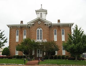
Pocahontas, AR 72455Gründung: 29. Oktober 1835 Gebildet aus: Lawrence County Vorwahl: 001 870 Demographie Einwohner: 17.969 (2010) Bevölkerungsdichte: 10,6 Einwohner/km² Geographie Fläche gesamt: 1.699 km² Wasserfläche: 11 km² Karte Website: www.randolphchamber.com Das Randolph County[3] ist ein County im US-amerikanischen Bundesstaat Arkansas. Bei der Volkszählung im Jahr 2010 hatte das County 17.969 Einwohner und eine Bevölkerungsdichte von 10,6 Einwohnern pro Quadratkilometer. Der Verwaltungssitz (County Seat) ist Pocahontas. Das County gehört zu den Dry Countys, was bedeutet, dass der Verkauf von Alkohol eingeschränkt oder verboten ist.
Inhaltsverzeichnis
Geografie
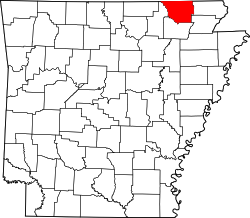
Das County liegt im Nordosten von Arkansas, grenzt im Norden an Missouri und hat eine Fläche von 1.699 Quadratkilometern, wovon 11 Quadratkilometer Wasserfläche sind. Es grenzt an folgende Countys:
Oregon County
(Missouri)Ripley County
(Missouri)Sharp County 
Clay County Lawrence County Greene County Geschichte
Das Randolph County wurde am 29. Oktober 1835[4] aus Teilen des Lawrence County gebildet. Benannt wurde es nach John Randolph of Roanoke (1773-1833), einem US - Senator aus Virginia, der von sich behauptete, ein Nachkomme der indianischen Prinzessin Pocahontas zu sein.
Demografische Daten
Historische Einwohnerzahlen Census Einwohner ± in % 1840 2196 — 1850 3275 50 % 1860 6261 90 % 1870 7466 20 % 1880 11.724 60 % 1890 14.485 20 % 1900 17.156 20 % 1910 18.987 10 % 1920 17.713 -7 % 1930 16.871 -5 % 1940 18.319 9 % 1950 15.982 -10 % 1960 12.520 -20 % 1970 12.645 1 % 1980 16.834 30 % 1990 16.558 -2 % 2000 18.195 10 % 2010 17.969 -1 % 1840–1890[5] 1900–1990[6] 2010[7] Nach der Volkszählung im Jahr 2000 lebten im Randolph County 18.195 Menschen. Davon wohnten 311 Personen in Sammelunterkünften, die anderen Einwohner lebten in 7.265 Haushalten und 5.245 Familien. Die Bevölkerungsdichte betrug 11 Einwohner pro Quadratkilometer. Ethnisch betrachtet setzte sich die Bevölkerung zusammen aus 96,99 Prozent Weißen, 0,97 Prozent Afroamerikanern, 0,53 Prozent amerikanischen Ureinwohnern, 0,07 Prozent Asiaten und 0,28 Prozent aus anderen ethnischen Gruppen. Unabhängig von der ethnischen Zugehörigkeit waren 1,15 Prozent der Bevölkerung spanischer oder lateinamerikanischer Abstammung.
Von den 7.265 Haushalten hatten 30,7 Prozent Kinder oder Jugendliche im Alter unter 18 Jahre, die mit ihnen zusammen lebten. 58,4 Prozent waren verheiratete, zusammenlebende Paare, 9,9 Prozent waren allein erziehende Mütter, 27,8 Prozent waren keine Familien. 24,7 Prozent aller Haushalte waren Singlehaushalte und in 12,1 Prozent lebten Menschen im Alter von 65 Jahren oder darüber. Die Durchschnittshaushaltsgröße lag bei 2,46 und die durchschnittliche Familiengröße bei 2,93 Personen.
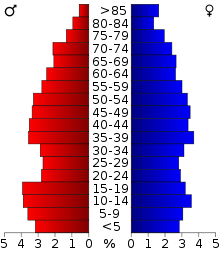
24,6 Prozent der Bevölkerung waren unter 18 Jahre alt, 8,3 Prozent zwischen 18 und 24, 25,7 Prozent zwischen 25 und 44, 24,3 Prozent zwischen 45 und 64 und 17,0 Prozent waren 65 Jahre oder älter. Das Durchschnittsalter betrug 39 Jahre. Auf 100 weibliche kamen statistisch 96,0 männliche Personen und auf 100 Frauen im Alter von 18 Jahren und darüber kamen durchschnittlich 90,5 Männer.
Das jährliche Durchschnittseinkommen eines Haushalts betrug 27.583 USD, das Durchschnittseinkommen der Familien 33.535 USD. Männer hatten ein Durchschnittseinkommen von 25.006 USD, Frauen 18.182 USD. Das Pro - Kopf - Einkommen betrug 14.502 USD. 11,9 Prozent der Familien und 15,3 Prozent der Einwohner lebten unterhalb der Armutsgrenze.[8]
Städte und Gemeinden
- Biggers
- Maynard
- O Kean
- Ravenden Springs
- Reyno
- Warm Springs
Einzelnachweise
- ↑ Auszug aus dem National Register of Historic Places - Nr. 96000910 Abgerufen am 30. August 2011
- ↑ Auszug aus dem National Register of Historic Places - Nr. 73000390 Abgerufen am 30. August 2011
- ↑ GNIS-ID: 69178. Abgerufen am 22. Februar 2011 (englisch).
- ↑ Auszug aus der Encyclopedia of Arkansas Abgerufen am 13. Februar 2011
- ↑ U.S. Census Bureau _ Census of Population and Housing Abgerufen am 17. Februar 2011
- ↑ Auszug aus Census.gov Abgerufen am 15. Februar 2011
- ↑ United States Census 2010 Abgerufen am 30. August 2011
- ↑ Randolph County, Arkansas Datenblatt mit den Ergebnissen der Volkszählung im Jahre 2000 bei factfinder.census.gov
Weblinks
- Handelskammer des Randolph County
- U.S. Census Buero, State & County QuickFacts - Randolph County
- Yahoo Bildersuche - Randolph County
- www.city-data.com - Randolph County
- Association of Arkansas Counties
Liste der Countys in Arkansas
Arkansas | Ashley | Baxter | Benton | Boone | Bradley | Calhoun | Carroll | Chicot | Clark | Clay | Cleburne | Cleveland | Columbia | Conway | Craighead | Crawford | Crittenden | Cross | Dallas | Desha | Drew | Faulkner | Franklin | Fulton | Garland | Grant | Greene | Hempstead | Hot Spring | Howard | Independence | Izard | Jackson | Jefferson | Johnson | Lafayette | Lawrence | Lee | Lincoln | Little River | Logan | Lonoke | Madison | Marion | Miller | Mississippi | Monroe | Montgomery | Nevada | Newton | Ouachita | Perry | Phillips | Pike | Poinsett | Polk | Pope | Prairie | Pulaski | Randolph | Saline | Scott | Searcy | Sebastian | Sevier | Sharp | St. Francis | Stone | Union | Van Buren | Washington | White | Woodruff | Yell
Wikimedia Foundation.


