- Ailili
-
Suco Ailili 
Daten Fläche 27,99 km²[1] Einwohnerzahl 429 (2010)[2] Chefe de Suco Sebastião Manuel de Carvalho
(Wahl 2009)Orte Position[3] Höhe Belbato (West) 8° 33′ S, 126° 0′ O-8.5461805305556126.00104928028[4] ? Nunuli 8° 32′ S, 125° 59′ O-8.5308333333333125.9886111111172 72 m Nai 8° 32′ S, 126° 0′ O-8.5323505261111125.99889278417[4] ? Ailili ist ein osttimoresischer Suco im Subdistrikt Manatuto (Distrikt Manatuto). Im Suco leben 429 Einwohner (2010,[2] 2004: 308[5]).
Geographie
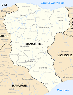
Der Suco Ailili liegt im Nordwesten des Subdistrikts Manatuto und hat eine Fläche von 27,99 km².[1] Westlich liegt der Suco Iliheu, nördlich der Suco Sau, östlich der Suco Aiteas und südlich der Suco Cribas. Außerdem grenzt Ailili im Südwesten an den Subdistrikt Laclo mit seinem Suco Lacumesac und an den Subdistrikt Laclubar mit seinem Suco Sananain. Die Grenze zu Cribas bildet der Fluss Lago Birac, der in den Sumasse mündet, der Grenzfluss zu Laclubar, Laclo und Iliheu. Der Sumasse mündet in einer breiten Front zwischen zwei Armen in den Nördlichen Laclo, der Ailili von Sau abtrennt.[6]
Der Ostgrenze folgt weitgehend die Überlandstraße von der Stadt Manatuto im Norden zum Ort Laclubar im Süden. Im Norden von Ailili liegen nah dem Nördlichen Laclo die Siedlungen des Sucos: Nai und Nunuli. An der Überlandstraße im Osten reichen mehrere Orte nach Ailili hinein. So liegt die Hälfte von Belbato in Ailili, die andere Hälfte in Aiteas.[7]
Im Suco befinden sich die zwei Aldeias Belebato und Iun.[8]
Politik
Bei den Wahlen von 2004/2005 wurde Francisco Soares Mau Sico zum Chefe de Suco gewählt.[9] Bei den Wahlen 2009 gewann Sebastião Manuel de Carvalho.[10]
Einzelnachweise
- ↑ a b Direcção Nacional de Estatística: Population Distribution by Administrative Areas Volume 2 English (Census 2010)
- ↑ a b Direcção Nacional de Estatística: Suco Report Volume 4 (englisch)
- ↑ Fallingrain.com: Directory of Cities, Towns, and Regions in East Timor
- ↑ a b Get Coordinate - Wiki Koordinaten ermitteln
- ↑ Statistisches Amt Timor-Leste Census 2004
- ↑ Timor-Leste GIS-Portal
- ↑ UNMIT: Timor-Leste District Atlas version02, August 2008
- ↑ Jornal da Républica mit dem Diploma Ministerial n.° 199/09 (Portugiesisch)
- ↑ Secretariado Técnico de Administração Eleitoral STAE: Eleições para Liderança Comunitária 2004/2005 - Resultados
- ↑ Secretariado Técnico de Administração Eleitoral STAE: Eleições para Liderança Comunitária 2009 - Resultados
Wikimedia Foundation.

