- Ichaboe Island
-
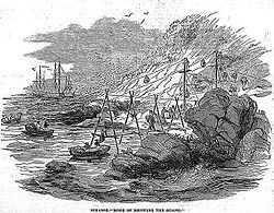
Ichaboe Island historische Ansicht von Ichaboe,
Mitte 19. JahrhundertGewässer Südatlantik Inselgruppe Pinguininseln Geographische Lage 26° 17′ 20″ S, 14° 56′ 12″ O-26.28888611111114.9365277777787Koordinaten: 26° 17′ 20″ S, 14° 56′ 12″ O Länge 425 m Breite 200 m Fläche 0.065 km² Höchste Erhebung Mount Stromboli
7 mEinwohner zeitweilig bis zu 15 Wissenschaftler Hauptort Observation Village Karte von Ichaboe Island Ichaboe Island bildet zusammen mit Little Ichaboe Island eine kleine vegetationslose Felseninselgruppe 48 km nördlich der Lüderitzbucht in Namibia. Sie gehört zu den Pinguininseln. Die Inseln ist Teil des Meob-Chamais Meeresschutzgebietes.
Ichaboe ist fast komplett von einer Flutmauer umschlossen und dient Wissenschaftlern als Basis. Zudem befindet sich hier eine Wetterstation. Seit den 40er Jahren des 19. Jahrhunderts wird auf Ichaboe Island Guano abgebaut.
Geographie
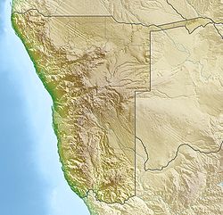
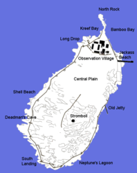
Die 6,5 Hektar große Insel liegt in der nördlichen Douglas Bay (Kartoffelbucht) 1,3 km vor der namibischen Küste in Namibia (südlich des Wreck Point). Die Insel misst 425 Meter von Nord nach Süd, und ist bis zu 200 Meter breit. Im Südosten erreicht sie ihre maximale Höhe von sieben Metern (Mount Stromboli). Die Insel besteht vorwiegend aus Granit.
Im Nordosten ist eine kleine, nur zeitweilig bewohnte Siedlung, das „Observation Village“.
Geschichte
Entdeckt wurde die Insel 1828 durch Kapitän Benjamin Morrell.
1861 wurde Ichaboe zu britischem Territorium erklärt und 1867 elf weitere Inseln der Pinguinselgruppe von Großbritannien annektiert. 1874 wurden die Hoheitsrechte über die annektierten Gebiete auf die Kapkolonie übertragen, die diese Inseln (und die Enklave Walvis Bay) selbst nach Gründung des deutschen Schutzgebietes Deutsch-Südwestafrika auf dem Festland behielt. 1921 kamen Walfischbucht und die Inseln vollends an Südafrika, bis sie am 28. Februar 1994 an Namibia zurückgegeben wurden.
Weblinks
- University of Cape Town: Ichaboe Island, Namibia - Seabird Colonies (englisch)
- Luftaufnahme der Insel
Inseln und Felsen innerhalb der Penguin IslandsAlbatross Rock | Black Rock | Black Sophie Rock | Boat Bay Rocks | Dumfudgeon Rocks | Flamingo Island | Gallovidea Reef | Halifax Island | Hollamsbird Island | Ichaboe Island | Little Roastbeef Islets | Marshall Rocks | Mercury Island | Neglectus Islet | North Long Island | Penguin Island | Plumpudding Island | Pomona Island | Possession Island | Seal Island | Shark Island | Sinclair Island | South Long Island | Staple Rocks
Wikimedia Foundation.
Schlagen Sie auch in anderen Wörterbüchern nach:
Ichaboe — 26°17′19.99″S 14°56′11.50″E / 26.2888861, 14.9365278 Ichaboe est une île de 6,5 hectares située à … Wikipédia en Français
Isla Ichaboe — Ichaboe Island[1] Representación Histórica de la Isla Localización País … Wikipedia Español
Mercury Island — from the air. Note the building on the center left of this photograph for scale … Wikipedia
Shark Island (Namibia) — Shark Island Haifischinsel Shark Island (rechte Bildmitte) mit der Lüderitzbucht (links) und der Stadt Lüderitz im Hintergrund … Deutsch Wikipedia
Sinclair Island — Vorlage:Infobox Insel/Wartung/Bild fehlt Sinclair Island (Roastbeef Island) Gewässer Baker Bay, Südatlantik Inselgruppe Penguin Islands Geographische Lage … Deutsch Wikipedia
Halifax Island — Gewässer Lüderitzbucht, Südatlantik Insel … Deutsch Wikipedia
Hollamsbird Island — Vorlage:Infobox Insel/Wartung/Bild fehlt Hollamsbird Island auch: Hollandsbird Island Gewässer Südatlantik Inselgruppe Pinguininseln Geographische Lage … Deutsch Wikipedia
Mercury Island — Luftaufnahme von Mercury Island Gewässer … Deutsch Wikipedia
Penguin Island (Namibia) — Vorlage:Infobox Insel/Wartung/Fläche fehltVorlage:Infobox Insel/Wartung/Höhe fehlt Penguin Island Pinguininsel Pinguininsel (links im … Deutsch Wikipedia
Plumpudding Island — Vorlage:Infobox Insel/Wartung/Bild fehlt Plumpudding Island Gewässer Baker Bay, Südatlantik Inselgruppe Penguin Islands Geographische Lage … Deutsch Wikipedia


