- Mercury Island
-
Mercury Island Luftaufnahme von Mercury Island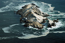
Gewässer Spencer Bay, Südatlantik Inselgruppe Penguin Islands Geographische Lage 25° 43′ 10″ S, 14° 31′ 51″ O-25.71944444444414.53083333333338Koordinaten: 25° 43′ 10″ S, 14° 31′ 51″ O 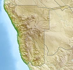

Länge 550 m Breite 120 m Fläche 0.03 km² Höchste Erhebung Jupiter Peak
38 mEinwohner (unbewohnt) Hauptort - Mercury Island ist eine drei Hektar große Felsinsel, an der Südatlantikküste von Namibia, 100 (einhundert) Kilometer nördlich von Lüderitz gelegen, sowie 960 Meter nördlich des nächstgelegenen Festlandspunktes am südlichen Ende der Spencer Bay. Die Insel ist Teil der Inselgruppe der Penguin Islands und Brutplatz vieler Seevögel und wurde viele Jahre lang durch eine Station zum Abbau des Guano bewirtschaftet. Heute findet sich hier eine Wetterstation und die Insel ist Ausgangspunkt für Forschungen.
Mercury Island liegt nur 1,5 Kilometer vor dem afrikanischen Festland und zur Insel gehört auch ein Nord-Inselchen (North Islet), ein Felsvorsprung etwa 30 Meter nördlich der Hauptinsel und mit dieser durch einen hölzernen Steg verbunden. Die Insel ist zu wesentlichen Teilen hohl und besitzt sechs Eingänge zu Höhlen in ihrem Inneren. Höchster Punkt der Insel ist der 38 Meter über dem Meeresspiegel liegende Jupiter Peak.
Die Inseln ist Teil des Meob-Chamais Meeresschutzgebietes und beheimatet die größte Brillenpinguinkolonie Namibias sowie die weltweit größte Population an Kormoranen (Phalacrocorax neglectus).
Weblinks
Albatross Rock | Black Rock | Black Sophie Rock | Boat Bay Rocks | Dumfudgeon Rocks | Flamingo Island | Gallovidea Reef | Halifax Island | Hollamsbird Island | Ichaboe Island | Little Roastbeef Islets | Marshall Rocks | Mercury Island | Neglectus Islet | North Long Island | Penguin Island | Plumpudding Island | Pomona Island | Possession Island | Seal Island | Shark Island | Sinclair Island | South Long Island | Staple Rocks


Wikimedia Foundation.