- Finchley
-
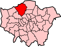
London Borough of Barnet 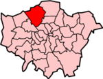
Lage in Greater LondonStatus London Borough Region Greater London Verwaltungssitz Southgate Fläche 86,74 km² (255.) Einwohner (2007) 329.700 (11.) ONS-Code 00AA Website www.barnet.gov.uk London Borough of Barnet [ˈbɑːnɪt] ist ein Stadtbezirk im Norden von London. 1965, bei der Gründung von Greater London, wurde er einerseits aus den Distrikten Finchley and Hendon und Friern Barnet in der Grafschaft Middlesex gebildet, andererseits aus Teilen der Gemeinden East Barnet und Barnet in der Grafschaft Hertfordshire.
Barnet unterhält eine Partnerschaft mit dem Berliner Bezirk Tempelhof-Schöneberg. Die ethnische Zusammensetzung der Bevölkerung ist wie folgt: 74,0 % Weiße, 12,3 % Südasiaten, 6,0 % Schwarze und 2,0 % Chinesen.
Nach dem im Stadtteil Mill Hill befindlichen Colleges St. Joseph wurde die von Herbert Kardinal Vaughan gegründete Missionsgesellschaft vom hl. Joseph von Mill Hill benannt.
Stadtteile
- Arkley
- Barnet
- Brunswick Park
- Brent Cross
- Brockley Hill
- Burnt Oak
- Childs Hill
- Church End Finchley
- Clitterhouse
- Colney Hatch
- Colindale
- Cricklewood
- East Barnet
- East Finchley
- Edgware
- Finchley
- Friern Barnet
- Golders Green
- Grahame Park
- Hale
- Hampstead Garden Suburb
- Hendon
- High Barnet
- Holders Hill
- Mill Hill
- Mill Hill East
- New Barnet
- New Southgate
- Monken Hadley
- North Finchley
- Oakleigh Park
- Southgate
- The Hyde
- Temple Fortune
- Totteridge
- West Hendon
- Whetstone
- Woodside Park
Persönlichkeiten
- Bob Anderson - Rennfahrer
- Peter Banks - Rockgitarrist
- Helena Bonham Carter - Schauspielerin
- Emma Bunton - Sängerin (Spice Girls)
- Antony Costa - Sänger
- John Hadley - Astronom und Mathematiker
- Hendon Mob - Pokerspieler
- Ashley Hutchings - Folkrocksänger und Bassist
- Christopher Kelk Ingold - Chemiker
- Jane March - Schauspielerin
- Mark McCammon - barbadischer Fußballspieler
- David Piper - Autorennfahrer
- Cicely Saunders - Ärztin
- Giles Gilbert Scott - Architekt
- Steven Stapleton - Musiker
- Wilhelm von Gloucester - Mitglied des britischen Königshauses
- Amy Winehouse - Soul-Sängerin
- Robert Pattinson - Schauspieler
Weblinks
- Barnet Borough Council (Bezirksverwaltung)
Barking and Dagenham | Barnet | Bexley | Brent | Bromley | Camden | City of London | City of Westminster | Croydon | Ealing | Enfield | Greenwich | Hackney | Hammersmith and Fulham | Haringey | Harrow | Havering | Hillingdon | Hounslow | Islington | Kensington and Chelsea | Kingston | Lambeth | Lewisham | Merton | Newham | Redbridge | Richmond | Southwark | Sutton | Tower Hamlets | Waltham Forest | Wandsworth
Sonstige Einteilung: Greater London | Inner London | Outer London | County of London
Wikimedia Foundation.