- Grant County (Minnesota)
-
Verwaltung US-Bundesstaat: Minnesota Verwaltungssitz: Elbow Lake Adresse des
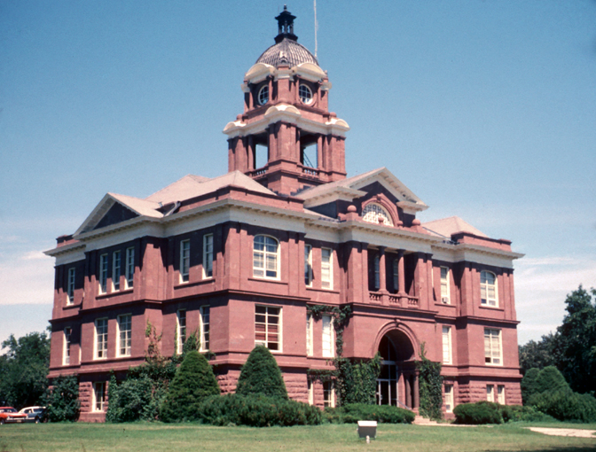
Verwaltungssitzes:County Courthouse
P.O. Box 1007
Elbow Lake, MN 56531-1007Gründung: 6. März 1868 Gebildet aus: Stevens County
Traverse County
Wilkin CountyVorwahl: 001 218 Demographie Einwohner: 6018 (2010) Bevölkerungsdichte: 4,3 Einwohner/km² Geographie Fläche gesamt: 1.490 km² Wasserfläche: 75 km² Karte 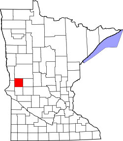
Website: www.co.grant.mn.us Das Grant County[2] ist ein County im US-amerikanischen Bundesstaat Minnesota. Bei der Volkszählung im Jahr 2010 hatte das County 6.018 Einwohner und eine Bevölkerungsdichte von 4,3 Einwohnern pro Quadratkilometer. Der Verwaltungssitz (County Seat) ist Elbow Lake.
Inhaltsverzeichnis
Geografie
Das County liegt im Westen von Minnesota und ist etwa 35 km von North Dakota sowie South Dakota entfernt. Das Grant County hat eine Fläche von 1.490 Quadratkilometern, wovon 75 Quadratkilometer Wasserfläche sind. Es grenzt an folgende Countys:
Wilkin County Otter Tail County 
Douglas County Traverse County Stevens County Pope County Geschichte
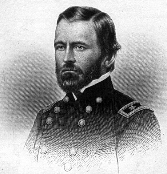
 U. S. Grant
Das Grant County wurde am 6. März 1868 aus Teilen des Stevens County, Traverse County und Wilkin County gebildet. Benannt wurde es nach Ulysses S. Grant (1822-1885), dem 18. Präsidenten der Vereinigten Staaten.
Demografische Daten
Historische Einwohnerzahlen Census Einwohner ± in % 1870 340 — 1880 3004 800 % 1890 6875 100 % 1900 8935 30 % 1910 9114 2 % 1920 9788 7 % 1930 9558 -2 % 1940 9828 3 % 1950 9542 -3 % 1960 8870 -7 % 1970 7462 -20 % 1980 7171 -4 % 1990 6246 -10 % 2000 6289 0,7 % 2010 6018 -4 % Vor 1900[3] 1900–1990[4] 2000[5] 2010[6]  Alterspyramide des Grant County (2000)
Nach der Volkszählung im Jahr 2000 lebten im Grant County 6.289 Menschen in 2.534 Haushalten und 1.740 Familien. Die Bevölkerungsdichte betrug vier Einwohner pro Quadratkilometer. Ethnisch betrachtet setzte sich die Bevölkerung zusammen aus 98,28 Prozent Weißen, 0,21 Prozent Afroamerikanern, 0,27 Prozent amerikanischen Ureinwohnern, 0,19 Prozent Asiaten und 0,30 Prozent aus anderen ethnischen Gruppen; 0,75 Prozent stammten von zwei oder mehr Ethnien ab. 0,52 Prozent der Bevölkerung waren spanischer oder lateinamerikanischer Abstammung.
Von den 2.534 Haushalten hatten 29,2 Prozent Kinder unter 18 Jahren, die bei ihnen lebten. 59,0 Prozent davon waren verheiratete, zusammenlebende Paare. 6,5 Prozent waren alleinerziehende Mütter und 31,3 Prozent waren keine Familien. 28,0 Prozent waren Singlehaushalte und in 16,5 Prozent der Haushalte lebten alleinstehende Menschen im Alter von 65 Jahren oder darüber. Die Durchschnittshaushaltsgröße lag bei 2,40 Personen, die durchschnittliche Familiengröße bei 2,94 Personen.
23,9 Prozent der Bevölkerung waren unter 18 Jahre alt. 6,9 Prozent waren zwischen 18 und 24, 23,1 Prozent zwischen 25 und 44, 23,2 Prozent zwischen 45 und 64 und 22,9 Prozent waren älter als 65 Jahre. Das Durchschnittsalter betrug 42 Jahre. Auf 100 weibliche kamen statistisch 94,5 männliche Personen. Auf 100 Frauen im Alter von 18 Jahren oder darüber kamen 94,3 Männer.
Das jährliche Durchschnittseinkommen eines Haushalts betrug 33.775 USD und das Durchschnittseinkommen einer Familie betrug 42.214 USD. Männer hatten ein Durchschnittseinkommen von 28.428 USD, Frauen 20.240 USD. Das Pro - Kopf - Einkommen betrug 17.131 USD. 6,0 Prozent der Familien und 8,4 Prozent der Einwohner lebten unterhalb der Armutsgrenze.[7]
Städte und Gemeinden
- Ashby
- Barrett
- Elbow Lake
- Herman
- Hoffman
- Norcross
- Wendell
Einzelnachweise
- ↑ Auszug aus dem National Register of Historic Places. Abgerufen am 13. März 2011
- ↑ GNIS-ID: 659471. Abgerufen am 22. Februar 2011 (englisch).
- ↑ U.S. Census Bureau - Census of Population and Housing Abgerufen am 15. März 2011
- ↑ Auszug aus Census.gov Abgerufen am 18. Februar 2011
- ↑ Auszug aus factfinder.census.gov Abgerufen am 18. Februar 2011
- ↑ United States Census 2010 Abgerufen am 26. Juli 2011
- ↑ Grant County, Minnesota Datenblatt mit den Ergebnissen der Volkszählung im Jahre 2000 bei factfinder.census.gov
Weblinks
-
 Commons: Grant County, Minnesota – Sammlung von Bildern, Videos und Audiodateien
 - Offizielle Webseite
- www.city-data.com

Liste der Countys in Minnesota
Aitkin | Anoka | Becker | Beltrami | Benton | Big Stone | Blue Earth | Brown | Carlton | Carver | Cass | Chippewa | Chisago | Clay | Clearwater | Cook | Cottonwood | Crow Wing | Dakota | Dodge | Douglas | Faribault | Fillmore | Freeborn | Goodhue | Grant | Hennepin | Houston | Hubbard | Isanti | Itasca | Jackson | Kanabec | Kandiyohi | Kittson | Koochiching | Lac qui Parle | Lake | Lake of the Woods | Le Sueur | Lincoln | Lyon | Mahnomen | Marshall | Martin | McLeod | Meeker | Mille Lacs | Morrison | Mower | Murray | Nicollet | Nobles | Norman | Olmsted | Otter Tail | Pennington | Pine | Pipestone | Polk | Pope | Ramsey | Red Lake | Redwood | Renville | Rice | Rock | Roseau | Scott | Sherburne | Sibley | St. Louis | Stearns | Steele | Stevens | Swift | Todd | Traverse | Wabasha | Wadena | Waseca | Washington | Watonwan | Wilkin | Winona | Wright | Yellow Medicine
Wikimedia Foundation.
Schlagen Sie auch in anderen Wörterbüchern nach:
Grant County, Minnesota — Seal … Wikipedia
Delaware Township, Grant County, Minnesota — Delaware Township, Minnesota Township … Wikipedia
North Ottawa Township, Grant County, Minnesota — North Ottawa Township, Minnesota Township … Wikipedia
Macsville Township, Grant County, Minnesota — Infobox Settlement official name = Macsville Township, Minnesota settlement type = Township nickname = motto = imagesize = image caption = image |pushpin pushpin label position =left pushpin map caption =Location within the state of Minnesota… … Wikipedia
Elbow Lake Township, Grant County, Minnesota — Infobox Settlement official name = Elbow Lake Township, Minnesota settlement type = Township nickname = motto = imagesize = image caption = image |pushpin pushpin label position =left pushpin map caption =Location within the state of Minnesota… … Wikipedia
Elk Lake Township, Grant County, Minnesota — Infobox Settlement official name = Elk Lake Township, Minnesota settlement type = Township nickname = motto = imagesize = image caption = image |pushpin pushpin label position =left pushpin map caption =Location within the state of Minnesota… … Wikipedia
Erdahl Township, Grant County, Minnesota — Infobox Settlement official name = Erdahl Township, Minnesota settlement type = Township nickname = motto = imagesize = image caption = image |pushpin pushpin label position =left pushpin map caption =Location within the state of Minnesota… … Wikipedia
Gorton Township, Grant County, Minnesota — Infobox Settlement official name = Gorton Township, Minnesota settlement type = Township nickname = motto = imagesize = image caption = image |pushpin pushpin label position =left pushpin map caption =Location within the state of Minnesota… … Wikipedia
Land Township, Grant County, Minnesota — Infobox Settlement official name = Land Township, Minnesota settlement type = Township nickname = motto = imagesize = image caption = image |pushpin pushpin label position =left pushpin map caption =Location within the state of Minnesota pushpin… … Wikipedia
Lawrence Township, Grant County, Minnesota — Infobox Settlement official name = Lawrence Township, Minnesota settlement type = Township nickname = motto = imagesize = image caption = image |pushpin pushpin label position =left pushpin map caption =Location within the state of Minnesota… … Wikipedia
Grant County (Minnesota)


18+
© Academic, 2000-2026
- Kontaktieren Sie uns: Unterstützung, Werbung
Wörterbücher Export, schritte mit PHP, Joomla, Drupal, WordPress, MODx.