- Martin County (Minnesota)
-
Verwaltung US-Bundesstaat: Minnesota Verwaltungssitz: Fairmont Adresse des
Verwaltungssitzes:County Courthouse
201 Lake Avenue
Fairmont, MN 56031-1852Gründung: 23. Mai 1857 Gebildet aus: Brown County
Faribault CountyVorwahl: 001 507 Demographie Einwohner: 20.840 (2010) Bevölkerungsdichte: 11,3 Einwohner/km² Geographie Fläche gesamt: 1.890 km² Wasserfläche: 52 km² Karte 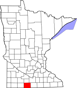
Website: www.co.martin.mn.us Das Martin County[2] ist ein County im US-amerikanischen Bundesstaat Minnesota. Bei der Volkszählung im Jahr 2010 hatte das County 20.840 Einwohner und eine Bevölkerungsdichte von 11,3 Einwohnern pro Quadratkilometer. Der Verwaltungssitz (County Seat) ist Fairmont.
Inhaltsverzeichnis
Geografie
Das County liegt im Süden von Minnesota, grenzt an Iowa und hat eine Fläche von 1.890 Quadratkilometern, wovon 52 Quadratkilometer Wasserfläche sind. Es grenzt an folgende Countys:
Cottonwood County Watonwan County Blue Earth County Jackson County 
Faribault County Emmet County
(Iowa)Kossuth County
(Iowa)Geschichte
 Martin
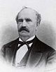
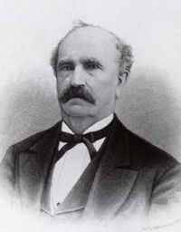
Das Martin County wurde am 23. Mai 1857 aus Teilen des Brown County und des Faribault County gebildet. Benannt wurde es nach Morgan Lewis Martin (1805-1887), einem US - Kongressabgeordneten aus dem Wisconsin - Territorium (1845-1847).
Demografische Daten
Historische Einwohnerzahlen Census Einwohner ± in % 1860 151 — 1870 3867 2.000 % 1880 5249 40 % 1890 9403 80 % 1900 16.936 80 % 1910 17.518 3 % 1920 21.085 20 % 1930 22.401 6 % 1940 24.656 10 % 1950 25.655 4 % 1960 26.986 5 % 1970 24.316 -10 % 1980 24.687 2 % 1990 22.914 -7 % 2000 21.802 -5 % 2010 20.840 -4 % Vor 1900[3] 1900–1990[4] 2000[5] 2010[6] Nach der Volkszählung im Jahr 2000 lebten im Martin County 21.802 Menschen in 9.067 Haushalten und 6.047 Familien. Die Bevölkerungsdichte betrug 12 Einwohner pro Quadratkilometer. Ethnisch betrachtet setzte sich die Bevölkerung zusammen aus 97,22 Prozent Weißen, 0,25 Prozent Afroamerikanern, 0,10 Prozent amerikanischen Ureinwohnern, 0,42 Prozent Asiaten, 0,02 Prozent Bewohnern aus dem pazifischen Inselraum und 1,26 Prozent aus anderen ethnischen Gruppen; 0,73 Prozent stammten von zwei oder mehr Ethnien ab. 1,93 Prozent der Bevölkerung waren spanischer oder lateinamerikanischer Abstammung, die verschiedenen der genannten Gruppen angehörten.
Von den 9.067 Haushalten hatten 29,8 Prozent Kinder unter 18 Jahren, die bei ihnen lebten. 56,6 Prozent davon waren verheiratete, zusammenlebende Paare. 7,2 Prozent waren alleinerziehende Mütter und 33,3 Prozent waren keine Familien. 30,0 Prozent waren Singlehaushalte und in 15,2 Prozent der Haushalte lebten alleinstehende Menschen im Alter von 65 Jahren oder darüber. Die Durchschnittshaushaltsgröße lag bei 2,35 Personen, die durchschnittliche Familiengröße bei 2,92 Personen.
24,8 Prozent der Bevölkerung waren unter 18 Jahre alt. 6,4 Prozent waren zwischen 18 und 24, 24,9 Prozent zwischen 25 und 44, 24,0 Prozent zwischen 45 und 64 und 19,9 Prozent waren älter als 65 Jahre. Das Durchschnittsalter betrug 42 Jahre. Auf 100 weibliche kamen statistisch 95,3 männliche Personen. Auf 100 Frauen im Alter von 18 Jahren oder darüber kamen 91,5 Männer.
Das jährliche Durchschnittseinkommen eines Haushalts betrug 34.810 USD und das Durchschnittseinkommen einer Familie betrug 44.541 USD. Männer hatten ein Durchschnittseinkommen von 30.467 USD, Frauen 21.780 USD. Das Pro - Kopf - Einkommen betrug 18.529 USD. 7,1 Prozent der Familien und 10,5 Prozent der Einwohner lebten unterhalb der Armutsgrenze.[7]
Städte und Gemeinden
- Ceylon
- Dunnell
- Fairmont
- Granada
- Northrop
- Ormsby1
- Sherburn
- Trimont
- Truman
- Welcome
1 - teilweise im Watonwan County
Einzelnachweise
- ↑ Auszug aus dem National Register of Historic Places. Abgerufen am 13. März 2011
- ↑ GNIS-ID: 659490. Abgerufen am 22. Februar 2011 (englisch).
- ↑ U.S. Census Bureau - Census of Population and Housing Abgerufen am 15. März 2011
- ↑ Auszug aus Census.gov Abgerufen am 18. Februar 2011
- ↑ Auszug aus factfinder.census.gov Abgerufen am 18. Februar 2011
- ↑ United States Census 2010 Abgerufen am 23. August 2011
- ↑ Martin County, Minnesota Datenblatt mit den Ergebnissen der Volkszählung im Jahre 2000 bei factfinder.census.gov
Weblinks
- Offizielle Webseite
- U.S. Census Buero, State & County QuickFacts - Martin County
- Yahoo Bildersuche - Martin County
- www.city-data.com - Martin County

Liste der Countys in Minnesota
Aitkin | Anoka | Becker | Beltrami | Benton | Big Stone | Blue Earth | Brown | Carlton | Carver | Cass | Chippewa | Chisago | Clay | Clearwater | Cook | Cottonwood | Crow Wing | Dakota | Dodge | Douglas | Faribault | Fillmore | Freeborn | Goodhue | Grant | Hennepin | Houston | Hubbard | Isanti | Itasca | Jackson | Kanabec | Kandiyohi | Kittson | Koochiching | Lac qui Parle | Lake | Lake of the Woods | Le Sueur | Lincoln | Lyon | Mahnomen | Marshall | Martin | McLeod | Meeker | Mille Lacs | Morrison | Mower | Murray | Nicollet | Nobles | Norman | Olmsted | Otter Tail | Pennington | Pine | Pipestone | Polk | Pope | Ramsey | Red Lake | Redwood | Renville | Rice | Rock | Roseau | Scott | Sherburne | Sibley | St. Louis | Stearns | Steele | Stevens | Swift | Todd | Traverse | Wabasha | Wadena | Waseca | Washington | Watonwan | Wilkin | Winona | Wright | Yellow Medicine


Wikimedia Foundation.