- Johnson County (Iowa)
-
Verwaltung US-Bundesstaat: Iowa Verwaltungssitz: Iowa City Adresse des
Verwaltungssitzes:County Administrative Building
913 S. Dubuque St.
Iowa City, IA 52240-4273Gründung: 21. Dezember 1837 Gebildet aus: Dubuque County
Muscatine CountyVorwahl: 001 319 Demographie Einwohner: 130.882 (2010) Bevölkerungsdichte: 82,3 Einwohner/km² Geographie Fläche gesamt: 1.614 km² Wasserfläche: 23 km² Karte 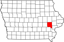
Website: www.johnson-county.com Das Johnson County[1] ist ein County im Bundesstaat Iowa der Vereinigten Staaten von Amerika. Bei der Volkszählung im Jahr 2010 hatte das County 130.882 Einwohner und eine Bevölkerungsdichte von 82,3 Einwohnern pro Quadratkilometer. Der Verwaltungssitz (County Seat) ist Iowa City, das mit diesem Namen als Hauptstadt des Iowa-Territoriums gegründet wurde.
Inhaltsverzeichnis
Geografie
Das County liegt im mittleren Osten von Iowa und hat eine Fläche von 1.614 Quadratkilometern, wovon 23 Quadratkilometer Wasserfläche sind. Es grenzt im Uhrzeigersinn an folgende Countys: Linn County, Cedar County, Muscatine County, Louisa County, Washington County und Iowa County.
Geschichte
Das Johnson County wurde am 21. Dezember 1837 gebildet. Benannt wurde es nach dem US-Vize-Präsidenten Richard M. Johnson.
Demografische Daten
Historische Einwohnerzahlen Census Einwohner ± in % 1840 1491 — 1850 4472 200 % 1860 17.573 300 % 1870 24.898 40 % 1880 25.420 2 % 1890 23.082 -9 % 1900 24.817 8 % 1910 25.914 4 % 1920 26.462 2 % 1930 30.276 10 % 1940 33.191 10 % 1950 45.756 40 % 1960 53.663 20 % 1970 72.127 30 % 1980 81.717 10 % 1990 96.119 20 % 2000 111.006 20 % 2010 130.882 20 % Vor 1900[2] Nach der Volkszählung im Jahr 2000 lebten im Johnson County 111.006 Menschen. Davon wohnten 8.006 Personen in Sammelunterkünften, die anderen Einwohner lebten in 44.080 Haushalten und 23.582 Familien. Die Bevölkerungsdichte betrug 70 Einwohner pro Quadratkilometer. Ethnisch betrachtet setzte sich die Bevölkerung zusammen aus 90,13 Prozent Weißen, 2,90 Prozent Afroamerikanern, 0,28 Prozent amerikanischen Ureinwohnern, 4,12 Prozent Asiaten, 0,04 Prozent Bewohnern aus dem pazifischen Inselraum und 1,01 Prozent aus anderen ethnischen Gruppen; 1,51 Prozent stammten von zwei oder mehr Ethnien ab. 2,51 Prozent der Bevölkerung waren spanischer oder lateinamerikanischer Abstammung, die verschiedenen der genannten Gruppen angehörten.
Von den 44.080 Haushalten hatten 26,5 Prozent Kinder und Jugendliche unter 18 Jahre, die bei ihnen lebten. 43,9 Prozent waren verheiratete, zusammenlebende Paare, 6,8 Prozent waren allein erziehende Mütter, 46,5 Prozent waren keine Familien, 30,2 Prozent waren Singlehaushalte und in 5,6 Prozent lebten Menschen im Alter von 65 Jahren oder darüber. Die Durchschnittshaushaltsgröße betrug 2,34 und die durchschnittliche Familiengröße lag bei 2,97 Personen.
Auf das gesamte County bezogen setzte sich die Bevölkerung zusammen aus 20,1 Prozent Einwohnern unter 18 Jahren, 23,4 Prozent zwischen 18 und 24 Jahren, 30,8 Prozent zwischen 25 und 44 Jahren, 18,2 Prozent zwischen 45 und 64 Jahren und 7,4 Prozent waren 65 Jahre oder darüber. Das Durchschnittsalter betrug 28 Jahre. Auf 100 weibliche Personen kamen statistisch 99,1 männliche Personen. Auf 100 Frauen im Alter von 18 Jahren oder darüber kamen 97,3 Männer.
Das jährliche Durchschnittseinkommen eines Haushalts betrug 40.060 US-$, das Durchschnittseinkommen der Familien betrug 60.112 $. Männer hatten ein Durchschnittseinkommen von 36.279 $, Frauen 29.793 $. Das Pro-Kopf-Einkommen betrug 22.220 $. 5,2 Prozent der Familien und 15,0 Prozent der Bevölkerung lebten unterhalb der Armutsgrenze. [5]
Städte und Gemeinden
- Coralville
- Cosgrove
- Cou Falls
- Hills
- Iowa City
- Lone Tree
- North Liberty
- Oakdale
- Oxford
- River Junction
- Solon
- Swisher
- Tiffin
- Twin View Heights
- University Heights
- Windham
Einzelnachweise
- ↑ Johnson County im Geographic Names Information System des United States Geological Survey. Abgerufen am 26. Februar 2011
- ↑ U.S. Census Bureau - Census of Population and Housing. Abgerufen am 15. März 2011
- ↑ Auszug aus Census.gov Abgerufen am 16. Februar 2011
- ↑ United States Census 2010 Abgerufen am 26. Februar 2011
- ↑ Johnson County, Iowa, Datenblatt mit den Ergebnissen der Volkszählung im Jahre 2000 bei factfinder.census.gov.
Weblinks
-
 Commons: Johnson County, Iowa – Sammlung von Bildern, Videos und Audiodateien
 - Offizielle Webseite

Liste der Countys in Iowa
Adair | Adams | Allamakee | Appanoose | Audubon | Benton | Black Hawk | Boone | Bremer | Buchanan | Buena Vista | Butler | Calhoun | Carroll | Cass | Cedar | Cerro Gordo | Cherokee | Chickasaw | Clarke | Clay | Clayton | Clinton | Crawford | Dallas | Davis | Decatur | Delaware | Des Moines | Dickinson | Dubuque | Emmet | Fayette | Floyd | Franklin | Fremont | Greene | Grundy | Guthrie | Hamilton | Hancock | Hardin | Harrison | Henry | Howard | Humboldt | Ida | Iowa | Jackson | Jasper | Jefferson | Johnson | Jones | Keokuk | Kossuth | Lee | Linn | Louisa | Lucas | Lyon | Madison | Mahaska | Marion | Marshall | Mills | Mitchell | Monona | Monroe | Montgomery | Muscatine | O'Brien | Osceola | Page | Palo Alto | Plymouth | Pocahontas | Polk | Pottawattamie | Poweshiek | Ringgold | Sac | Scott | Shelby | Sioux | Story | Tama | Taylor | Union | Van Buren | Wapello | Warren | Washington | Wayne | Webster | Winnebago | Winneshiek | Woodbury | Worth | Wright
Wikimedia Foundation.
Schlagen Sie auch in anderen Wörterbüchern nach:
Johnson County, Iowa — Infobox U.S. County county = Johnson County state = Iowa map size = 225 founded = 1838 seat = Iowa City | area total sq mi =623 area land sq mi =614 area water sq mi =9 area percentage = 1.42% census estimate yr = 2007 pop = 125,692 density km2… … Wikipedia
National Register of Historic Places listings in Johnson County, Iowa — Location of Johnson County in Iowa This is a list of the National Register of Historic Places listings in Johnson County, Iowa. This is intended to be a complete list of the properties and districts on the National Register of Historic Places in… … Wikipedia
Sharon Township, Johnson County, Iowa — Sharon Township is one of the twenty townships of Johnson County, Iowa, United States. It is located on the southern county line, about convert|6|mi|km southwest of Iowa City (at Township 78 North, Range 7 West of the 5th Principal Meridian). It… … Wikipedia
Johnson County — is the name of several counties in the United States: Johnson County, Arkansas Johnson County, Georgia Johnson County, Illinois Johnson County, Indiana Johnson County, Iowa Johnson County, Kansas Johnson County, Kentucky Johnson County, Missouri… … Wikipedia
Iowa County (Iowa) — Iowa County Courthouse in Marengo, gelistet im NRHP Nr. 81000247[1] Verwaltung … Deutsch Wikipedia
Johnson County — Es gibt in den Vereinigten Staaten zwölf Countys mit dem Namen Johnson County: Johnson County (Arkansas) Johnson County (Georgia) Johnson County (Illinois) Johnson County (Indiana) Johnson County (Iowa) Johnson County (Kansas) Johnson County… … Deutsch Wikipedia
Iowa County, Iowa — Infobox U.S. County county = Iowa County state = Iowa seallink = map size = 250 founded = 1843 seat = Marengo largest city = area total sq mi = 587 area total km2 = 1521 area land sq mi = 586 area land km2 = 1519 area water sq mi = 1 area water… … Wikipedia
Johnson County Courthouse — can refer to:* Johnson County Courthouse (Arkansas), (Clarksville, Arkansas) * Johnson County Courthouse (Georgia), (Wrightsville, Georgia) * Johnson County Courthouse (Iowa), (Iowa City, Iowa) * Johnson County Courthouse (Missouri), (Warrensburg … Wikipedia
Johnson County (Nebraska) — Johnson County Courthouse, gelistet im NRHP Nr. 89002246[1] Verwaltung … Deutsch Wikipedia
Johnson County Courthouse — bezeichnet mehrere gleichnamige, im NRHP gelistete, Objekte: Johnson County Courthouse (Arkansas), ID Nr. 91000680 Johnson County Courthouse (Georgia), ID Nr. 80001101 Johnson County Courthouse (Iowa), ID Nr. 75000692 Johnson County Courthouse… … Deutsch Wikipedia
Johnson County (Iowa)

18+
© Academic, 2000-2026
- Kontaktieren Sie uns: Unterstützung, Werbung
Wörterbücher Export, schritte mit PHP, Joomla, Drupal, WordPress, MODx.