- Kaminoyama
-
Kaminoyama-shi
上山市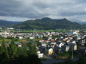
Geographische Lage in Japan 

Region: Tōhoku Präfektur: Yamagata Koordinaten: 38° 9′ N, 140° 16′ O38.149444444444140.26777777778Koordinaten: 38° 8′ 58″ N, 140° 16′ 4″ O Basisdaten Fläche: 241 km² Einwohner: 33.408
(1. Oktober 2011)Bevölkerungsdichte: 139 Einwohner je km² Gemeindeschlüssel: 06207-3 Symbole Baum: Japanische Eibe Blume: Garten-Chrysantheme Vogel: Seidenreiher Rathaus Adresse: Kaminoyama City Hall
1-1-10, Kawasaki
Kaminoyama-shi
Yamagata 999-3192Webadresse: http://www.city.kaminoyama.yamagata.jp Lage Kaminoyamas in der Präfektur Yamagata 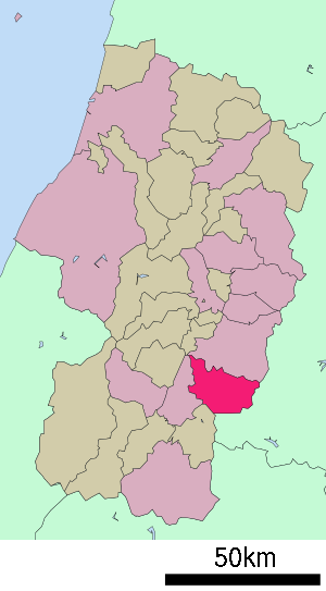
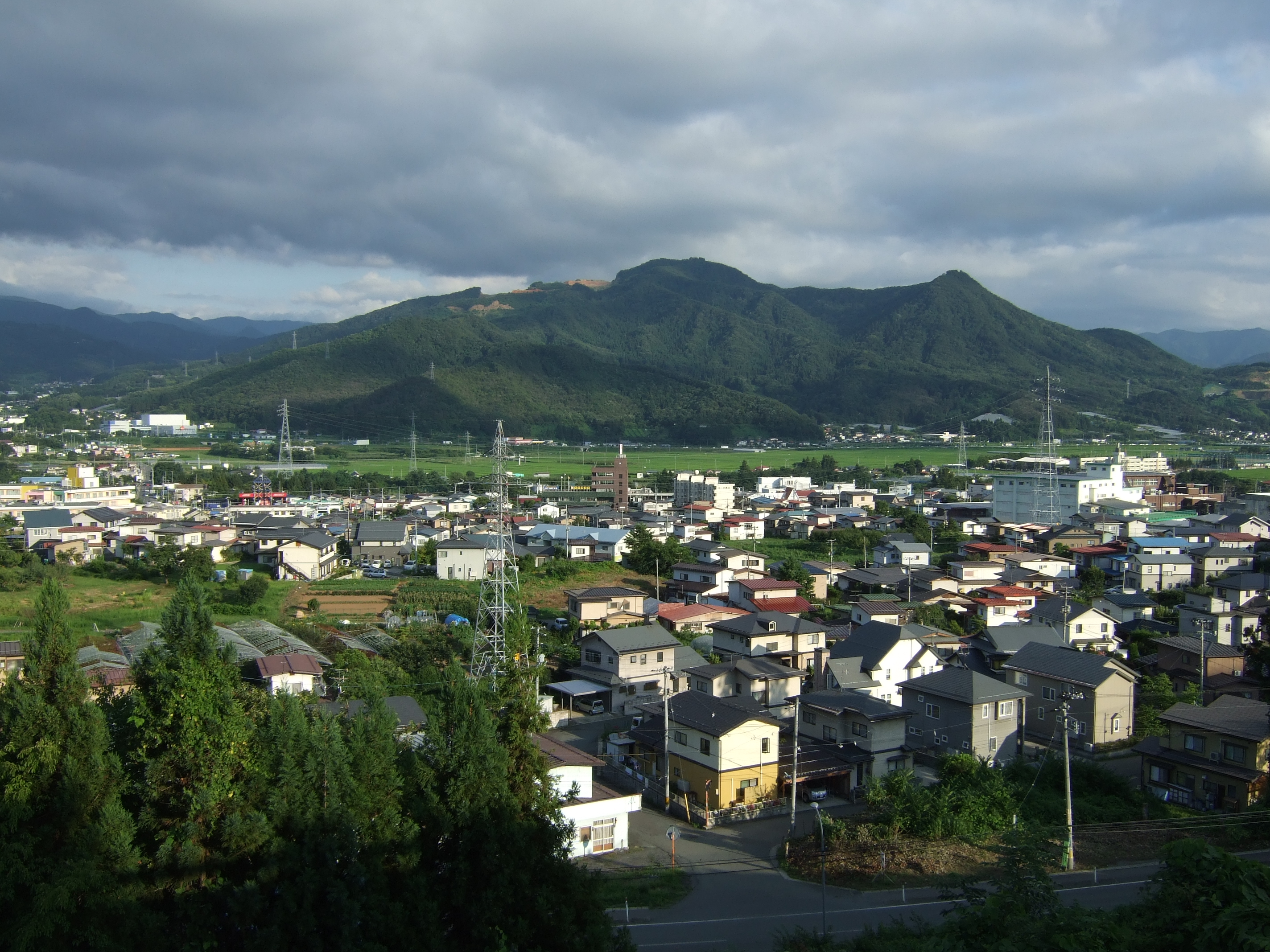
Kaminoyama (jap. 上山市, -shi) ist eine Stadt in der Präfektur Yamagata in Japan.
Inhaltsverzeichnis
Geographie
Kaminoyama liegt südlich von Yamagata und nördlich von Yonezawa.
Geschichte
Die Stadt Kaminoyama wurde am 1. Oktober 1954 gegründet.
Sehenswürdigkeiten
- Kaminoyama-Onsen (Heiße Quelle)
Verkehr
- Zug:
- JR Yamagata-Shinkansen: Bahnhof Kaminoyama-Onsen, nach Fukushima oder Shinjo
- JR Ōu-Hauptlinie
- Straßen:
- Tōhoku-Chūō-Autobahn: Abfahrt Yamagata-Kaminoyama
- Nationalstraße 13
- Nationalstraße 458
Angrenzende Städte und Gemeinden
- Präfektur Yamagata
- Präfektur Miyagi
- Shichikashuku
- Kawasaki
Weblinks
 Commons: Kaminoyama – Sammlung von Bildern, Videos und Audiodateien
 Gemeinden und Landkreise in der Präfektur Yamagata
Kreisfreie Städte (shi): Higashine | Kaminoyama | Murayama | Nagai | Nan’yō | Obanazawa | Sagae | Sakata | Shinjō | Tendō | Tsuruoka | Yamagata (Verwaltungssitz) | Yonezawa
Akumi-gun: Yuza | Higashimurayama-gun: Nakayama | Yamanobe | Higashiokitama-gun: Kawanishi | Takahata | Higashitagawa-gun: Shōnai | Mikawa | Kitamurayama-gun: Ōishida | Mogami-gun: Funagata | Kaneyama | Mamurogawa | Mogami | Okura | Sakegawa | Tozawa | Nishimurayama-gun: Asahi | Kahoku | Nishikawa | Ōe | Nishiokitama-gun: Iide | Oguni | Shirataka
Wikimedia Foundation.
Schlagen Sie auch in anderen Wörterbüchern nach:
Kaminoyama — shi (上山市) Vue sur Kaminoyama avec la montagne Hayama en arrière plan Administration Pays Japon Région Tōhoku … Wikipédia en Français
Kaminoyama — Original name in latin Kaminoyama Name in other language Kaminoyama State code JP Continent/City Asia/Tokyo longitude 38.15389 latitude 140.27361 altitude 177 Population 35593 Date 2012 01 19 … Cities with a population over 1000 database
Kaminoyama, Yamagata — Kaminoyama (上山市; shi, lit. up mountain) is a city located in Yamagata, Japan.As of 2003, the city has an estimated population of 36,712 and the density of 152.36 persons per km². The total area is 240.95 km².The city was founded on October 1,… … Wikipedia
Kaminoyama Onsen Station — Infobox Station name=nihongo|Kaminoyama Onsen Station|かみのやま温泉駅|Kaminoyama Onsen eki type= image size= image caption= address= coordinates= coord|38.1521|140.278|display=inline,title line= other= structure= platform= depth= levels= tracks= parking … Wikipedia
Kaminoyama Castle — nihongo|Kaminoyama Castle|上山城|kaminoyamajō, also known as Tsukioka Castle , is a hirayamashiro (a castle located on a hill surrounded by plains) located in Kaminoyama, Yamagata Prefecture, Japan. The castle was built in 1535 by Buei Yoshitada of… … Wikipedia
Kaminoyama Domain — The nihongo|Kaminoyama Domain|上山藩|Kaminoyama han was a Japanese domain of the Edo period, located in Dewa Province.List of lords*Matsudaira clan (Nomi) (Fudai; 40,000 koku)#Shigetada #Shigenao*Gamō clan (Tozama; 40,000 koku)#Tadatomo*Toki clan… … Wikipedia
Kaminoyama-shi — Admin ASC 2 Code Orig. name Kaminoyama shi Country and Admin Code JP.00.2112407 JP … World countries Adminstrative division ASC I-II
Siege of Kaminoyama — Infobox Military Conflict conflict=Siege of Kaminoyama partof=the Sekigahara Campaign caption= date=1600 place=Kaminoyama, Yamagata province casus= territory=Kaminoyama falls to the Tokugawa result=Tokugawa victory combatant1=Tokugawa support… … Wikipedia
Matsudaira Nobutsune (Kaminoyama) — In this Japanese name, the family name is Matsudaira . Matsudaira Nobutsune (松平 信庸?, September 22, 1844 – March 5, 1918) was a Japanese samurai of the late Edo period who served as lord of the Kaminoyama domain in Dewa Province. Succeeding to the … Wikipedia
JP-06 — Karte Basisdaten Verwaltungssitz: Yamagata Region: Tōhoku … Deutsch Wikipedia
Kaminoyama


18+
© Academic, 2000-2026
- Kontaktieren Sie uns: Unterstützung, Werbung
Wörterbücher Export, schritte mit PHP, Joomla, Drupal, WordPress, MODx.