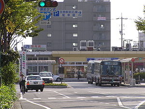
Kasaoka

Kasaoka
Kasaoka-shi
笠岡市
Kasaoka
Geographische Lage in Japan
Kasaoka (Japan)
Red pog.svg
Region: Chūgoku
Präfektur: Okayama
Koordinaten: 34° 30′ N, 133° 30′ O34.507180555556133.50744166667Koordinaten: 34° 30′ 26″ N, 133° 30′ 27″ O
Basisdaten
Fläche: 103,60 km²
Einwohner: 53.566
(1. September 2011)
Bevölkerungsdichte: 517 Einwohner je km²
Gemeindeschlüssel: 33204-6
Symbole
Baum: Ginkgo
Blume: Garten-Chrysantheme
Rathaus
Adresse: Kasaoka City Hall
1-1, Chūō-chō
Kasaoka-shi
Okayama 714-8601
Webadresse: http://www.city.kasaoka.okayama.jp
Lage Kasaokas in der Präfektur Okayama
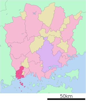
Lage Kasaokas in der Präfektur

Kasaoka (jap. 笠岡市, -shi) ist eine Stadt in der japanischen Präfektur Okayama.

Inhaltsverzeichnis

Geographie

Kasaoka liegt östlich von Fukuyama und westlich von Okayama an der Seto-Inlandsee.

Geschichte

Die Stadt Kasaoka wurde am 1. April 1952 gegründet.

Verkehr

Kasaoka ist an die Sanyō-Autobahn und an die Nationalstraße 2 nach Ōsaka und Kitakyūshū angeschlossen. Mit dem Zug kann man mit der JR Sanyō-Hauptlinie nach Kōbe und Kitakyūshū.

Angrenzende Städte und Gemeinden

Kasaoka grenzt an Ibara, Asakuchi und Fukuyama.

Weblinks

 Commons: Kasaoka – Sammlung von Bildern, Videos und Audiodateien

Wikimedia Foundation.

Игры ⚽ Поможем написать курсовую

Schlagen Sie auch in anderen Wörterbüchern nach:

  • Kasaoka — Original name in latin Kasaoka Name in other language Kasaoka State code JP Continent/City Asia/Tokyo longitude 34.5 latitude 133.5 altitude 3 Population 58461 Date 2012 01 19 …   Cities with a population over 1000 database

  • Kasaoka, Okayama — nihongo|Kasaoka|笠岡市|Kasaoka shi is a city located in Okayama, Japan.As of 2003, the city has an estimated population of 58,060 and the density of 427.01 persons per km². The total area is 135.97 km².The city was founded on April 1, 1952.External… …   Wikipedia

  • Kasaoka Station — is a train station in Kasaoka, Okayama Prefecture, Japan.Lines*West Japan Railway Company **Sanyō Main LineLayoutAdjacent stations !colspan=5|JR West ###@@@KEYEND@@@### …   Wikipedia

  • Kasaoka-shi — Admin ASC 2 Code Orig. name Kasaoka shi Country and Admin Code JP.31.1859989 JP …   World countries Adminstrative division ASC I-II

  • Kasaoka — ▪ Japan       city, southwestern Okayama ken (prefecture), Honshu, Japan, facing the Inland Sea. It was an old temple town until its port flourished during the Tokugawa period (1603–1867). The opening of a major railway line and a textile plant… …   Universalium

  • Islas Kasaoka — (笠岡諸島 Kasaoka Shotō) Localización geográfica / administrativa Océano (mar) Mar Interior de Seto Continente (s …   Wikipedia Español

  • JP-33 — Karte Basisdaten Verwaltungssitz: Okayama Region: Chūgoku …   Deutsch Wikipedia

  • Katsuji Yamashita — Yamashita Katsuji (* 12. Mai 1906 in Kasaoka in Japan; † 5. Dezember 1969) war Professor für Betriebswirtschaftslehre an der Universität Kōbe. Biographie Yamashita wurde in der Präfektur Okayama geboren. Er besuchte die Handelshochschule Ohita… …   Deutsch Wikipedia

  • Daimon Station (Hiroshima) — Station building Daimon Station (大門駅, Daimon eki?) is a …   Wikipedia

  • Taurine — Taurine …   Wikipedia

Share the article and excerpts

Direct link
Do a right-click on the link above
and select “Copy Link”