- Le Mont-Dore
-
Basisdaten Gebiet Neukaledonien Provinz Süd Höhe 0–825 m Fläche 643 km² Einwohner 24.195 (2004) Bevölkerungsdichte 37,6 Einwohner je km² INSEE-Code 98817 Postleitzahl 98810[1] Website http://mont-dore.nc/ Karte 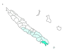
Le Mont-Dore ist eine Gemeinde in der Südprovinz in Neukaledonien.
Die Gemeinde liegt größtenteils auf der Hauptinsel Grande Terre, aber auch weitere kleine Inseln vor der Küste, wie beispielsweise die Île Ouen, gehören dazu. Mont-Dore liegt in der Nachbarschaft zu Nouméa und gehört somit in Teilen zum Großraum Nouméa. Die Orte in Le Mont-Dore sind: La Capture, La Conception(?), La Coulée, Mont-Dore (Hauptort), Ouara (Nouvelle-Calédonie), Plum (Nouvelle-Calédonie), Prony (Nouvelle-Calédonie) und Saint-Louis (Nouvelle-Calédonie).
Bevölkerung
Bevölkerungsentwicklung in Mont-Dore 1956–2004[2] 1956 1963 1969 1976 1983 1989 1996 2004 1.288 2.640 4.809 10.659 14.614 16.370 20.780 24.195 Weblinks
 Commons: Le Mont-Dore – Sammlung von Bildern, Videos und Audiodateien
Einzelnachweise
Gemeinden in NeukaledonienBelep | Bouloupari | Bourail | Canala | Dumbéa | Farino | Hienghène | Houaïlou | L’Île-des-Pins | Kaala-Gomen | Koné | Kouaoua | Koumac | La Foa | Lifou | Maré | Moindou | Le Mont-Dore | Nouméa | Ouégoa | Ouvéa | Païta | Poindimié | Ponérihouen | Pouébo | Pouembout | Poum | Poya | Sarraméa | Thio | Touho | Voh | Yaté
Wikimedia Foundation.
Schlagen Sie auch in anderen Wörterbüchern nach:
Mont-Dore (Puy-de-Dome) — Mont Dore (Puy de Dôme) Pour les articles homonymes, voir Mont Dore. Mont Dore Le village avec le puy de Sancy en arrière plan … Wikipédia en Français
Mont-Dore (Puy-de-Dôme) — Pour les articles homonymes, voir Mont Dore. Mont Dore Le village avec le puy de Sancy en arrière plan … Wikipédia en Français
Mont-dore (puy-de-dôme) — Pour les articles homonymes, voir Mont Dore. Mont Dore Le village avec le puy de Sancy en arrière plan … Wikipédia en Français
Mont-Dore — Mont Dore … Deutsch Wikipedia
Mont-Dore (station) — Mont Dore Une vue aérienne de la station serait la bienvenue. Administration Pays France Subdivision administrative Auvergne Localité Mont Dore Site Internet … Wikipédia en Français
Mont-dore — Cette page d’homonymie répertorie les différentes communes ou anciennes communes françaises partageant un même nom. Pour l’article homophone, voir Mont d Or. la commune de Mont Dore dans le Puy de Dôme La station de ski du Mont Dore … Wikipédia en Français
Mont-Dore — Mont Dore … Wikipedia Español
Mont Dore-Bahn — führt von Dore (1009 m ü. M.) in Frankreich auf den Mont Dore, Lungenheilanstalt (1246 m), überwindet daher einen Höhenunterschied von 177 m. Die Bahn ist als eingleisige Seilstandbahn mit 1 m Spurweite und selbsttätiger Ausweiche in der Mitte… … Enzyklopädie des Eisenbahnwesens
Mont-Dore — (M. les Bains, spr. mongdōr läbäng), Badeort im franz. Depart. Puy de Dôme, Arrond. Clermont, 1050 m ü. M., in den Mont Dore Bergen an der Dordogne und der Orléansbahn gelegen, mit einer kalten (12°) und zehn warmen Heilquellen (eisenhaltige… … Meyers Großes Konversations-Lexikon
Mont-Dore — [mɔ̃ dɔːr], seenreiches Vulkangebiet in der Auvergne, Frankreich. Auf granitischem Unterbau erheben sich trachytische und basische Decken und Kuppen, darunter der Puy de Sancy (1 886 m über dem Meeresspiegel), höchste Erhebung Frankreichs… … Universal-Lexikon
Mont Dore — (spr. mong dōr ), Berggruppe im franz. Depart. Puy de Dôme, zu den Gebirgen der Auvergne gehörig, gegen S. durch ein ödes Hochland vom Cantal getrennt, im N. in die Berggruppe des Puy de Dôme übergehend, wird im O. vom Tal des Allier, im W. von… … Meyers Großes Konversations-Lexikon
Le Mont-Dore
18+
© Academic, 2000-2026
- Kontaktieren Sie uns: Unterstützung, Werbung
Wörterbücher Export, schritte mit PHP, Joomla, Drupal, WordPress, MODx.