- Leon County (Florida)
-
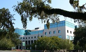 Leon County Courthouse in Tallahassee
Verwaltung US-Bundesstaat: Florida Verwaltungssitz: Tallahassee Adresse des
Verwaltungssitzes:County Commission
301 S. Monroe Street
Tallahassee, Florida 32301Gründung: 29. Dezember 1824 Gebildet aus: Gadsden County Vorwahl: 001 850 Demographie Einwohner: 239.452 (2000) Bevölkerungsdichte: 138,7 Einwohner/km² Geographie Fläche gesamt: 1.818 km² Wasserfläche: 91 km² Karte 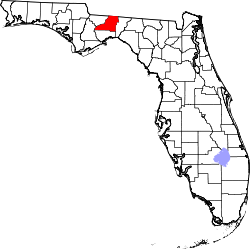
Website: www.co.leon.fl.us Das Leon County[1] ist ein County im Bundesstaat Florida der Vereinigten Staaten von Amerika. Der Verwaltungssitz (County Seat) ist Tallahassee.
Inhaltsverzeichnis
Geschichte
Das Leon County wurde am 29. Dezember 1824 aus Teilen des Gadsden County gebildet. Benannt wurde es nach Juan Ponce de León, dem spanischen Eroberer und wohl der erste Europäer, der Florida betrat.
Teile des 1936 ausgewiesenen Nationalforstes Apalachicola National Forest erstrecken sich bis in das County.
Geografie
Das County hat eine Fläche von 1.818 Quadratkilometern, wovon 91 Quadratkilometer Wasserfläche sind. Es grenzt im Uhrzeigersinn an folgende Countys: Jefferson County, Wakulla County, Liberty County und Gadsden County.
Demografische Daten
Historische Einwohnerzahlen Census Einwohner ± in % 1830 6494 — 1840 10.713 60 % 1850 11.442 7 % 1860 12.343 8 % 1870 15.236 20 % 1880 19.662 30 % 1890 17.752 -10 % 1900 19.887 10 % 1910 19.427 -2 % 1920 18.059 -7 % 1930 23.476 30 % 1940 31.646 30 % 1950 51.590 60 % 1960 74.225 40 % 1970 103.047 40 % 1980 148.655 40 % 1990 192.493 30 % 2000 239.452 20 % Vor 1900[2] 1900–1990[3]
Nach der Volkszählung im Jahr 2000 lebten im Leon County 239.452 Menschen in 96.521 Haushalten und 54.341 Familien. Die Bevölkerungsdichte betrug 139 Einwohner pro Quadratkilometer. Ethnisch betrachtet setzte sich die Bevölkerung zusammen aus 66,36 Prozent Weißen, 29,11 Prozent Afroamerikanern, 0,29 Prozent amerikanischen Ureinwohnern, 1,91 Prozent Asiaten, 0,04 Prozent Bewohnern aus dem pazifischen Inselraum und 0,78 Prozent aus anderen ethnischen Gruppen; 1,52 Prozent stammten von zwei oder mehr Ethnien ab. 3,51 Prozent der Gesamtbevölkerung waren spanischer oder lateinamerikanischer Abstammung.
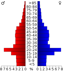 Alterspyramide für das Leon County
Von den 96.521 Haushalten hatten 27,7 Prozent Kinder und Jugendliche unter 19 Jahre, die bei ihnen lebten. 39,8 Prozent waren verheiratete, zusammenlebende Paare, 13,0 Prozent waren allein erziehende Mütter und 43,7 Prozent waren keine Familien. 29,7 Prozent waren Singlehaushalte und in 5,8 Prozent lebten Menschen im Alter von 65 Jahren oder darüber. Die Durchschnittshaushaltsgröße betrug 2,34 und die durchschnittliche Familiengröße betrug 2,95 Personen.
21,3 Prozent der Bevölkerung waren unter 18 Jahre alt, 21,4 Prozent zwischen 18 und 24, 28,9 Prozent zwischen 25 und 44, 20,0 Prozent zwischen 45 und 64 und 8,3 Prozent der Bevölkerung war 65 Jahre oder älter. Das Durchschnittsalter betrug 30 Jahre. Auf 100 weibliche Personen kamen statistisch 91,1 männliche Personen und auf 100 Frauen im Alter von 18 Jahren oder darüber kamen 87,9 Männer.
Das jährliche Durchschnittseinkommen eines Haushalts betrug 37.517 USD, das Durchschnittseinkommen der Familien 52.962 USD. Männer hatten ein Durchschnittseinkommen von 35.235 USD, Frauen 28.110 USD. Das Prokopfeinkommen betrug 21.024 USD. 9,4 Prozent der Familien und 18,2 Prozent der Bevölkerung lebten unterhalb der Armutsgrenze. [4]
Weiterführende Bildungseinrichtungen
- Capital Culinary Institute in Tallahassee
- Florida Agricultural & Mechanical University in Tallahassee
- Florida State University in Tallahassee
- Keiser College in Tallahassee
- Smith Chapel Bible College in Tallahassee
- Tallahassee Community College in Tallahassee
Städte und Gemeinden
- Miccosukee
- Ochlockonee
- Tallahassee
- Woodville
Einzelnachweise
- ↑ GNIS-ID: 306916. Abgerufen am 22. Februar 2011 (englisch).
- ↑ U.S. Census Bureau - Census of Population and Housing. Abgerufen am 15. März 2011
- ↑ Auszug aus Census.gov. Abgerufen am 14. Februar 2011
- ↑ Leon County, Florida, Datenblatt mit den Ergebnissen der Volkszählung im Jahre 2000 bei factfinder.census.gov.
Weblinks
 Commons: Leon County, Florida – Sammlung von Bildern, Videos und Audiodateien
Liste der Countys in Florida
Alachua | Baker | Bay | Bradford | Brevard | Broward | Calhoun | Charlotte | Citrus | Clay | Collier | Columbia | De Soto | Dixie | Duval | Escambia | Flagler | Franklin | Gadsden | Gilchrist | Glades | Gulf | Hamilton | Hardee | Hendry | Hernando | Highlands | Hillsborough | Holmes | Indian River | Jackson | Jefferson | Lafayette | Lake | Lee | Leon | Levy | Liberty | Madison | Manatee | Marion | Martin | Miami-Dade | Monroe | Nassau | Okaloosa | Okeechobee | Orange | Osceola | Palm Beach | Pasco | Pinellas | Polk | Putnam | Santa Rosa | Sarasota | Seminole | St. Johns | St. Lucie | Sumter | Suwannee | Taylor | Union | Volusia | Wakulla | Walton | Washington
Wikimedia Foundation.
Schlagen Sie auch in anderen Wörterbüchern nach:
Leon County, Florida, in the American Civil War — Leon County, Florida participated heavily in the Civil War. Leon County had 3 Confederate army camps: Camp Leon located in what is now Belair on the south side of Tallahassee, Camp Lay, and Camp Mary Davis.Leon County sent several of its sons off … Wikipedia
County Road 342 (Leon County, Florida) — Leon County Road 0342 is an east west route in northern Leon County, Florida, USA.It connects State Road 155 (Meridian Road) in the west with US 319/SR 61 (Thomasville Road) and Leon County Road 151 (Centerville Road). Combined with Leon County… … Wikipedia
County Road 2196 (Leon County, Florida) — Leon County Road 2196 is an east west route in eastern Leon County, Florida, USA.Starting at Franklin Street in downtown Tallahassee, it runs parrarel to Apalachee Parkway for its entire route, crossing Magnolia Street, Blair Stone Road, Paul… … Wikipedia
Leon County, Florida Sheriff's Office — Infobox Police Department name = Leon County Sheriff s Office motto = established = jurisdiction = County sworn = non sworn = CSO = stations = jails = helicopters = policeboats = chief = sheriff = Larry Campbell commissioner = supervisor = The… … Wikipedia
Leon County, Florida — Infobox U.S. County county = Leon County state = Florida founded = December 29 1824 seat = Tallahassee area total sq mi =702 area land sq mi =667 area water sq mi =35 area percentage = 4.99% census yr = 2000 pop = 239452 density km2 =139 named… … Wikipedia
County Road 356 (Leon County, Florida) — Leon County Road 0356 is an east west route in northwestern Tallahassee, Florida, USA, connecting US 27 (Monroe Street) with State Road 263 (Capital Circle).County Road 0356 is also known as Fred George Road … Wikipedia
County Road 1555 (Leon County, Florida) — Leon County Road 1555 is a short north/south county route in central Tallahassee. CR 1555 helps to bypass downtown Tallahassee to the east … Wikipedia
National Register of Historic Places listings in Leon County, Florida — Location of Leon County in Florida This is a list of the National Register of Historic Places listings in Leon County, Florida. This is intended to be a complete list of the properties and districts on the National Register of Historic Places in… … Wikipedia
Oaklawn Plantation (Leon County, Florida) — Location of Oaklawn Plantation. Oaklawn Plantation was a large plantation of 5326 acres (21½ km2) in northern Leon County in the U.S. state of Florida. It was established around 1850 by Captain William Lester (born December 24, 1790) of… … Wikipedia
Belair, Leon County, Florida — Belair is an unincorporated community in southern Leon County, Florida, United States, south of Tallahassee. It is in the area bordered on the south by Capital Circle SE, on the north by Campbell Pond, on the west by Woodville Highway, and on the … Wikipedia
Leon County (Florida)


18+
© Academic, 2000-2026
- Kontaktieren Sie uns: Unterstützung, Werbung
Wörterbücher Export, schritte mit PHP, Joomla, Drupal, WordPress, MODx.