- Nagbukel
-
Municipality of Nagbukel Lage von Nagbukel in der Provinz Ilocos Sur 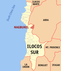
Basisdaten Bezirk: Ilocos-Region Provinz: Ilocos Sur Barangays: 12 Distrikt: 2. Distrikt von Ilocos Sur PSGC: 012913000 Einkommensklasse: 5. Einkommensklasse Haushalte: 910 Zensus 1. Mai 2000Einwohnerzahl: 4.764 Zensus 1. August 2007Koordinaten: 17° 25′ N, 120° 34′ O17.41748120.57495Koordinaten: 17° 25′ N, 120° 34′ O Postleitzahl: 2725 Geographische Lage auf den Philippinen 

Nagbukel Nagbukel ist eine Stadtgemeinde in der philippinischen Provinz Ilocos Sur. Sie grenzt im Osten an die Provinz Abra. Das Gebiet liegt an den Ausläufern der Kordilleren. Im Jahre 2000 zählte Nagbukel 4671 Einwohner und 910 Haushalte. Die Menschen leben hauptsächlich von der Landwirtschaft.
Nagbukel ist in folgende zwölf Baranggays aufgeteilt:
- Balaweg
- Bandril
- Bantugo
- Cadacad
- Casilagan
- Casocos
- Lapting
- Mapisi
- Mission
- Poblacion East
- Poblacion West
- Taleb
Städte und Stadtgemeinden in der Provinz Ilocos SurStadtgemeinden: Alilem | Banayoyo | Bantay | Burgos | Cabugao | Caoayan | Cervantes | Galimuyod | Gregorio del Pilar | Lidlidda | Magsingal | Nagbukel | Narvacan | Quirino | Salcedo | San Emilio | San Esteban | San Ildefonso | San Juan | San Vicente | Santa | Santa Catalina | Santa Cruz | Santa Lucia | Santa Maria | Santiago | Santo Domingo | Sigay | Sinait | Sugpon | Suyo | Tagudin
Wikimedia Foundation.
Schlagen Sie auch in anderen Wörterbüchern nach:
Nagbukel — es un municipio de quinta categoría situado en la provincia de Ilocos Sur en Filipinas. Según el censo de 2000, tiene 4.671 habitantes en 910 hogares. Barangays Nagbukel tiene 12 barangays. Balaweg Bandril Bantugo Cadacad Casilagan Casocos… … Wikipedia Español
Nagbukel — Original name in latin Nagbukel Name in other language Nagbukel, Nagbuquel State code PH Continent/City Asia/Manila longitude 17.4471 latitude 120.5247 altitude 22 Population 0 Date 2011 07 31 … Cities with a population over 1000 database
Nagbukel, Ilocos Sur — Nagbukel Municipality Map of Ilocos Sur showing the location of Nagbukel … Wikipedia
Pugo, La Union — Pugo is a 5th class municipality in the province of La Union, Philippines. Pugo is the smallest town of La Union in terms of land area, and is located at the foot of the Santo Tomas mountain range just about an hour away from Baguio City. It is… … Wikipedia
PH-ILS — Provinz Ilocos Sur Basisdaten Bezirk: Ilocos Region Hau … Deutsch Wikipedia
Vigan — City of Vigan Lage von Vigan in der Provinz Ilocos Sur Basisdaten Bezirk: Ilocos Region … Deutsch Wikipedia
Ilocos Sur — Infobox Philippine province name = Ilocos Sur sealfile = Ph seal ilocos sur.png region = Ilocos Region (Region I) capital = Vigan City founded = 1572 pop2000 = 594,206 pop2000rank = 41st largest popden2000 = 230 popden2000rank = 34th highest… … Wikipedia
Narvacan, Ilocos Sur — Narvacan Municipality Map of Ilocos Sur showing the location of Narvacan … Wikipedia
Luba, Abra — Infobox Philippine municipality infoboxtitle = Municipality of Luba sealfile = locatormapfile = Ph locator abra luba.png caption = Map of Abra showing the location of Luba. region = Cordillera Administrative Region province = Abra districts =… … Wikipedia
Cervantes, Ilocos Sur — Cervantes Municipality Map of Ilocos Sur showing the location of Cervantes … Wikipedia
Nagbukel


18+
© Academic, 2000-2026
- Kontaktieren Sie uns: Unterstützung, Werbung
Wörterbücher Export, schritte mit PHP, Joomla, Drupal, WordPress, MODx.