- Cervantes (Philippinen)
-
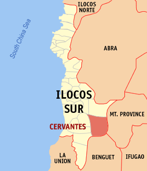
Municipality of Cervantes Lage von Cervantes in der Provinz Ilocos Sur 
Basisdaten Bezirk: Ilocos-Region Provinz: Ilocos Sur Barangays: 13 Distrikt: 2. Distrikt von Ilocos Sur PSGC: 012908000 Einkommensklasse: 4. Einkommensklasse Haushalte: 2673 Zensus 1. Mai 2000Einwohnerzahl: 14.116 Zensus 1. August 2007Bevölkerungsdichte: 43,2 Einwohner je km² Fläche: 327 km² Koordinaten: 16° 59′ N, 120° 41′ O16.98325120.67658Koordinaten: 16° 59′ N, 120° 41′ O Geographische Lage auf den Philippinen 

Cervantes Cervantes ist eine Stadtgemeinde in der philippinischen Provinz Ilocos Sur. Cervantes ist sehr bergig und wird von mehreren Flüssen durchquert, wie dem Abra. Die höchsten Berge des Areals sind der Mount Namogian mit etwa 2000 m und der Mount Monserrat mit etwa 1700 m. Die Bevölkerung lebt hauptsächlich vom Reisanbau.
Cervantes ist in folgende 13 Baranggays aufgeteilt:
- Aluling
- Comillas North
- Comillas South
- Concepcion
- Dinwede East
- Dinwede West
- Libang
- Pilipil
- Remedios
- Rosario
- San Juan
- San Luis
- Malaya
Städte und Stadtgemeinden in der Provinz Ilocos SurStadtgemeinden: Alilem | Banayoyo | Bantay | Burgos | Cabugao | Caoayan | Cervantes | Galimuyod | Gregorio del Pilar | Lidlidda | Magsingal | Nagbukel | Narvacan | Quirino | Salcedo | San Emilio | San Esteban | San Ildefonso | San Juan | San Vicente | Santa | Santa Catalina | Santa Cruz | Santa Lucia | Santa Maria | Santiago | Santo Domingo | Sigay | Sinait | Sugpon | Suyo | Tagudin
Wikimedia Foundation.
Schlagen Sie auch in anderen Wörterbüchern nach:
Cervantes (Begriffsklärung) — Cervantes ist der Familienname folgender Personen: Alfredo Castillo Cervantes, mexikanischer Jurist Annabel Cervantes (* 1969), katalanische Autorin Antonio Cervantes (* 1945), kolumbianischer Boxer Francisco Cervantes de Salazar (1514?–1575),… … Deutsch Wikipedia
Santa (Philippinen) — Municipality of Santa Lage von Santa in der Provinz Ilocos Sur Basisdaten Bezirk: I … Deutsch Wikipedia
PH-ILS — Provinz Ilocos Sur Basisdaten Bezirk: Ilocos Region Hau … Deutsch Wikipedia
Vigan — City of Vigan Lage von Vigan in der Provinz Ilocos Sur Basisdaten Bezirk: Ilocos Region … Deutsch Wikipedia
Liste der Boxweltmeister der WBA — In dieser Liste stehen alle Boxer, die sich den Weltmeistertitel der World Boxing Association (kurz WBA) holten. Ursprung der WBA ist die National Boxing Association (kurz NBA), die sich 1921 gründete. 1962 änderte die NBA ihren Namen in WBA um.… … Deutsch Wikipedia
Philippinisches Spanisch — Spanisch ist eine Sprache, die auf den Philippinen von großer historischer Bedeutung ist. Sie war bis 1973 Amtssprache und bis ins Jahr 1987 ein Pflichtfach an philippinischen Hochschulen. Nach den letzten Zählungen von 1990 sprechen zwei bis… … Deutsch Wikipedia
Spanische Sprache — Spanisch (español, castellano) Gesprochen in Spanien, großen Teilen Mittel und Südamerikas, außerdem in den USA, Marokko, Äquatorialguinea und Westsahara Sprecher insgesamt ca. 447 Mio. (Stand: 2000) Muttersprachler ca. 388 Mio. Zweitsprachler ca … Deutsch Wikipedia
Union Latina — Lateinische Union 2005 Die Lateinische Union ist eine Organisation verschiedener Staaten, in denen romanische Sprachen gesprochen werden. Ihr Ziel ist es, das allgemeine Erbe und die unterschiedlichen Identitäten der lateinischen Sprache in der… … Deutsch Wikipedia
Unión Latina — Lateinische Union 2005 Die Lateinische Union ist eine Organisation verschiedener Staaten, in denen romanische Sprachen gesprochen werden. Ihr Ziel ist es, das allgemeine Erbe und die unterschiedlichen Identitäten der lateinischen Sprache in der… … Deutsch Wikipedia
Spanische Literatur — Spanische Literatur. I. Das Mutterland Spanien. A) Geschichtliche Übersicht. Die Grundlage der Spanischen Sprache bilde: die Lateinische Sprache, welche schon in ältester Zeit mit der römischen Herrschaft (s. Spanien S. 353) eingeführt ward u.… … Pierer's Universal-Lexikon
Cervantes (Philippinen)

18+
© Academic, 2000-2026
- Kontaktieren Sie uns: Unterstützung, Werbung
Wörterbücher Export, schritte mit PHP, Joomla, Drupal, WordPress, MODx.