- San Vicente (Ilocos Sur)
-
Municipality of San Vicente Lage von San Vicente in der Provinz Ilocos Sur 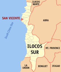
Basisdaten Bezirk: Ilocos-Region Provinz: Ilocos Sur Barangays: 7 Distrikt: 1. Distrikt von Ilocos Sur PSGC: 012921000 Einkommensklasse: 4. Einkommensklasse Haushalte: 2248 Zensus 1. Mai 2000Einwohnerzahl: 11.907 Zensus 1. August 2007Bevölkerungsdichte: 1001 Einwohner je km² Fläche: 11,9 km² Koordinaten: 17° 35′ N, 120° 21′ O17.58119120.34699Koordinaten: 17° 35′ N, 120° 21′ O Postleitzahl: 2726 Vorwahl: +63 77 Geographische Lage auf den Philippinen 

San Vicente San Vicente ist eine Stadtgemeinde in der philippinischen Provinz Ilocos Sur und liegt am Südchinesischen Meer. In dem nur 11,9 km² großen Gebiet lebten im Jahre 2000 10.877 Menschen, wodurch sich eine Bevölkerungsdichte von 914 Einwohnern pro km² ergibt. Das flache Gelände wird auch vom Bantaoay River durchquert.
San Vicente ist in folgende sieben Baranggays aufgeteilt:
- Bantaoay
- Bayubay Norte
- Bayubay Sur
- Lubong
- Poblacion
- Pudoc
- San Sebastian
Städte und Stadtgemeinden in der Provinz Ilocos SurStadtgemeinden: Alilem | Banayoyo | Bantay | Burgos | Cabugao | Caoayan | Cervantes | Galimuyod | Gregorio del Pilar | Lidlidda | Magsingal | Nagbukel | Narvacan | Quirino | Salcedo | San Emilio | San Esteban | San Ildefonso | San Juan | San Vicente | Santa | Santa Catalina | Santa Cruz | Santa Lucia | Santa Maria | Santiago | Santo Domingo | Sigay | Sinait | Sugpon | Suyo | Tagudin
Wikimedia Foundation.
Schlagen Sie auch in anderen Wörterbüchern nach:
San Vicente (Ilocos Sur) — Saltar a navegación, búsqueda San Vicente es un municipio de quinta categoría situado en la provincia de Ilocos Sur en Filipinas. Según el censo de 2000, cuenta con 10.877 habitantes en 2.248 hogares. El municipio es conocido por su producción de … Wikipedia Español
San Vicente, Ilocos Sur — San Vicente is a 5th class municipality in the province of Ilocos Sur, Philippines. According to the 2000 census, it has a population of 10,877 people in 2,248 households.The municipality is known for its production of beautiful furniture made… … Wikipedia
San Ildefonso, Ilocos Sur — San Ildefonso is a 5th class municipality in the province of Ilocos Sur, Philippines. According to the 2000 census, it has a population of 5,584 people in 1,127 households. The municipality was established in March 1625. As of May 2007, San… … Wikipedia
San Juan (Ilocos Sur) — Municipality of San Juan (Lapog) Lage von San Juan (Lapog) in der Provinz Ilocos Sur Basisdaten Bezirk … Deutsch Wikipedia
San Esteban (Ilocos Sur) — Municipality of San Esteban Lage von San Esteban in der Provinz Ilocos Sur Basisdaten Bezirk … Deutsch Wikipedia
San Ildefonso (Ilocos Sur) — Municipality of San Ildefonso Lage von San Ildefonso in der Provinz Ilocos Sur Basisdaten Bezirk … Deutsch Wikipedia
San Vicente — bezeichnet geografische Orte in folgenden Ländern: in Argentinien Partido San Vicente, Verwaltungseinheit in der Provinz Buenos Aires San Vicente (Buenos Aires), eine Stadt in der Provinz Buenos Aires San Vicente (Córdoba), eine Stadt in der… … Deutsch Wikipedia
San Vicente — ( Saint Vincent ) can refer to:*Argentina **San Vicente, Buenos Aires **San Vicente Partido *Bolivia **San Vicente, Bolivia *Chile **San Vicente, Chile *Colombia **San Vicente del Caguán *Costa Rica **San Vicente, Costa Rica *El Salvador **San… … Wikipedia
Santa Maria, Ilocos Sur — Santa Maria is a 3rd class municipality in the province of Ilocos Sur, Philippines. According to the 2007 census final count, it has a population of 28,002 people.BarangaysSanta Maria is politically subdivided into 33 barangays. * Ag agrao *… … Wikipedia
Ilocos Sur — Provincia de Ilocos Sur Provincia de Filipinas … Wikipedia Español
San Vicente (Ilocos Sur)


18+
© Academic, 2000-2026
- Kontaktieren Sie uns: Unterstützung, Werbung
Wörterbücher Export, schritte mit PHP, Joomla, Drupal, WordPress, MODx.