Nome Census Area

Nome Census Area
Nome Census Area

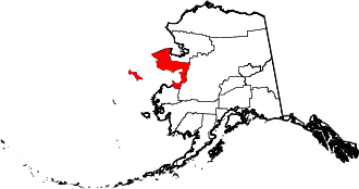
Der Nome Census Area ist ein Census Area im US-Bundesstaat Alaska auf der Seward-Halbinsel und entlang der Ostküste des Norton Sounds. Er beinhaltet auch die Sankt-Lorenz-Insel im Beringmeer.

Im Jahr 2010 betrug die Bevölkerungszahl 9.492. Nome gehört zum Unorganized Borough und hat somit keinen Verwaltungssitz. Der Census Area hat eine Fläche von 73.253 km², wovon 59.572 km² auf Land und 13.681 km² auf Wasser entfallen. Die größte Stadt der Region ist Nome.

Teile des Yukon Delta und des Alaska Maritime National Wildlife Refuges sowie des Bering Land Bridge National Preserves liegen im Nome Census Area.

Weblinks

 Commons: Nome Census Area – Sammlung von Bildern, Videos und Audiodateien

Wikimedia Foundation.

Игры ⚽ Нужен реферат?

Schlagen Sie auch in anderen Wörterbüchern nach:

  • Nome Census Area — Admin ASC 2 Code Orig. name Nome Census Area Country and Admin Code US.AK.180 US …   World countries Adminstrative division ASC I-II

  • Nome Census Area, Alaska — Nome Census Area is a census area located in the state of Alaska, United States. As of the 2000 census, the population was 9,196. It is part of the unorganized borough and therefore has no borough seat. Its largest community by far is the city of …   Wikipedia

  • National Register of Historic Places listings in Nome Census Area, Alaska — Location of the Nome Census Area in Alaska This is a list of the National Register of Historic Places listings in Nome Census Area, Alaska. This is intended to be a complete list of the properties and districts on the National Register of… …   Wikipedia

  • Liste der Registered Historic Places im Nome Census Area — Die Liste der Registered Historic Places im Nome Census Area führt alle Bauwerke und historischen Stätten im Nome Census Area des US Bundesstaates Alaska auf, die in das National Register of Historic Places aufgenommen wurden. Inhaltsverzeichnis… …   Deutsch Wikipedia

  • List of Alaska borough and census area name etymologies — This is a list of Alaska borough and census area name etymologies. *Aleutians East Borough: named for its location in the eastern part of the Aleutian Islands. Aleutian may be from the Chukchi word aliat , meaning island . *Aleutians West Census… …   Wikipedia

  • Prince of Wales-Outer Ketchikan Census Area — Prince of Wales Hyder Census Area (seit 19. Mai 2008) Prince …   Deutsch Wikipedia

  • Prince of Wales - Outer Ketchikan Census Area — Prince of Wales Hyder Census Area (seit 19. Mai 2008) Prince …   Deutsch Wikipedia

  • Skagway-Hoonah-Angoon Census Area — Hoonah Angoon Census Area (seit 5. Juni 2007) Skagway Hoonah Angoon Census Area (von 1992 bi …   Deutsch Wikipedia

  • Skagway-Yakutat-Angoon Census Area — Hoonah Angoon Census Area (seit 5. Juni 2007) Skagway Hoonah Angoon Census Area (von 1992 bi …   Deutsch Wikipedia

  • Wrangell-Petersburg Census Area — (seit 1. Juni 2008) Wrangell Petersburg Census Area (bis 1. Juni 2008) …   Deutsch Wikipedia

Share the article and excerpts

Direct link
Do a right-click on the link above
and select “Copy Link”