- Yukon-Koyukuk Census Area
-
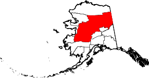
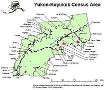
Der Yukon-Koyukuk Census Area ist ein Census Area im US-Bundesstaat Alaska, der sich vom Norton Sound im Westen entlang der namensgebenden Flüsse Yukon und Koyukuk sowie der Brookskette durch das Interior bis zur Grenze zum kanadischen Territorium Yukon erstreckt.
Im Jahr 2010 betrug die Bevölkerungszahl 5.588. Die Bevölkerungsdichte von 0,0173 Einwohnern/km² ist die niedrigste aller Bezirke der Vereinigten Staaten. Yukon-Koyukuk gehört zum Unorganized Borough und hat somit keinen Verwaltungssitz. Der Census Area hat eine Fläche von 382.910 km² und ist damit größer als Japan. 377.878 km² der Fläche entfallen auf Land und 5032 km² auf Wasser.
Die größte Stadt der Region ist Galena. Der Yukon-Koyukuk Census Area ist das größte und am dünnsten besiedelte County-äquivalente Gebiet der Vereinigten Staaten.
Die National Wildlife Refuges Innoko, Kanuti, Nowitna und Yukon Flats sowie Teile von Arctic, Koyukuk und Selawik National Wildlife Refuge, dem Gates-of-the-Arctic-Nationalpark und dem Yukon-Charley Rivers National Preserve liegen im Yukon-Koyukuk Census Area.
Weblinks
- QuickFacts auf census.gov (englisch)
Regionen: Alaskan Bush | Interior | North Slope | Panhandle | South Central | Tanana Valley
Boroughs: Aleutians East | Anchorage | Bristol Bay | Denali | Fairbanks North Star | Haines | Juneau | Kenai Peninsula | Ketchikan Gateway | Kodiak Island | Lake and Peninsula | Matanuska-Susitna | North Slope | Northwest Arctic | Skagway | Sitka | Wrangell | Yakutat | Unorganized Borough
Census Areas: Aleutians West | Bethel | Dillingham | Hoonah-Angoon | Nome | Petersburg | Prince of Wales-Hyder | Southeast Fairbanks | Valdez-Cordova | Wade Hampton | Yukon-Koyukuk
Wichtige Städte: Anchorage | Barrow | Bethel | Fairbanks | Homer | Juneau | Kenai | Ketchikan | Kodiak | Kotzebue | Nome | Palmer | Petersburg | Seward | Sitka | Unalaska | Valdez | Wasilla
Wikimedia Foundation.


