- Ketchikan Gateway Borough
-
Verwaltung US-Bundesstaat: Alaska Verwaltungssitz: Ketchikan Gründung: Demographie Einwohner: 13.477 (2010) Bevölkerungsdichte: 4,2 Einwohner/km² Geographie Fläche gesamt: 4.545 km² Wasserfläche: 1.349 km² Karte 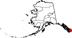
Ketchikan Gateway Borough ist ein Borough in Alaska, Vereinigte Staaten. 2010 lebten hier 13.477 Menschen. Verwaltungssitz ist Ketchikan.
Am 19. Mai 2008 fielen große Teile des damaligen Prince of Wales-Outer Ketchikan Census Areas, darunter die Region Outer Ketchikan, an den Borough. [1]
Der Bezirk hatte vor der Eingliederung von 2008 eine Fläche von 4545 Quadratkilometern; davon sind 3194 Quadratkilometer Land und 1349 Quadratkilometer (29,69 Prozent) Wasserflächen.
Einzelnachweise
Weblinks
- Ketchikan Gateway Borough
- Karte des Ketchikan Gateway Borough (pdf-Datei; 320 kB)
 Politische Gliederung Alaskas
Regionen: Alaskan Bush | Interior | North Slope | Panhandle | South Central | Tanana Valley
Boroughs: Aleutians East | Anchorage | Bristol Bay | Denali | Fairbanks North Star | Haines | Juneau | Kenai Peninsula | Ketchikan Gateway | Kodiak Island | Lake and Peninsula | Matanuska-Susitna | North Slope | Northwest Arctic | Skagway | Sitka | Wrangell | Yakutat | Unorganized Borough
Census Areas: Aleutians West | Bethel | Dillingham | Hoonah-Angoon | Nome | Petersburg | Prince of Wales-Hyder | Southeast Fairbanks | Valdez-Cordova | Wade Hampton | Yukon-Koyukuk
Wichtige Städte: Anchorage | Barrow | Bethel | Fairbanks | Homer | Juneau | Kenai | Ketchikan | Kodiak | Kotzebue | Nome | Palmer | Petersburg | Seward | Sitka | Unalaska | Valdez | Wasilla
Wikimedia Foundation.
Schlagen Sie auch in anderen Wörterbüchern nach:
Ketchikan Gateway Borough — Admin ASC 2 Code Orig. name Ketchikan Gateway Borough Country and Admin Code US.AK.130 US … World countries Adminstrative division ASC I-II
Ketchikan Gateway Borough, Alaska — Infobox U.S. County county = Ketchikan Gateway Borough state = Alaska founded = seat = Ketchikan | area total sq mi =1754 area water sq mi =521 area percentage = 29.69% census yr = 2000 pop = 14070 density km2 =4 web = www.borough.ketchikan.ak.us … Wikipedia
Ketchikan Gateway Borough School District — The Ketchikan Gateway Borough School District provides k 12 public education to the children of the Ketchikan Gateway Borough and Ketchikan, Alaska.choolsHigh schools*Ketchikan High School *Revilla Junior/Senior High SchoolMiddle school*Shoenbar… … Wikipedia
National Register of Historic Places listings in Ketchikan Gateway Borough, Alaska — Location of the Ketchikan Gateway Borough in Alaska This is a list of the National Register of Historic Places listings in Ketchikan Gateway Borough, Alaska. This is intended to be a complete list of the properties and districts on the National… … Wikipedia
Liste der Registered Historic Places im Ketchikan Gateway Borough — Die Liste der Registered Historic Places im Ketchikan Gateway Borough führt alle Bauwerke und historischen Stätten im Ketchikan Gateway Borough des US Bundesstaates Alaska auf, die in das National Register of Historic Places aufgenommen wurden.… … Deutsch Wikipedia
Borough De Ketchikan Gateway — Ketchikan Gateway Borough, Alaska Administration Pays … Wikipédia en Français
Borough de ketchikan gateway — Ketchikan Gateway Borough, Alaska Administration Pays … Wikipédia en Français
Borough de Ketchikan Gateway — Saltar a navegación, búsqueda Borough de Ketchikan Gateway Localización: Alaska, Estados Unidos Superficie Total … Wikipedia Español
Borough de Ketchikan Gateway — 55°33′N 131°05′W / 55.55, 131.083 … Wikipédia en Français
Ketchikan — Ketchikan, Alaska Bandera … Wikipedia Español
Ketchikan Gateway Borough

18+
© Academic, 2000-2026
- Kontaktieren Sie uns: Unterstützung, Werbung
Wörterbücher Export, schritte mit PHP, Joomla, Drupal, WordPress, MODx.