- Rankin County
-
Verwaltung US-Bundesstaat: Mississippi Verwaltungssitz: Brandon Adresse des
Verwaltungssitzes:County Courthouse
305 Government Street
Brandon, MS 39042-0000Gründung: 4. Februar 1828 Gebildet aus: Hinds County Vorwahl: 001 601 Demographie Einwohner: 141.617 (2010) Bevölkerungsdichte: 70,6 Einwohner/km² Geographie Fläche gesamt: 2.088 km² Wasserfläche: 82 km² Karte 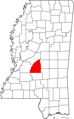
Website: www.rankincounty.org Das Rankin County[1] ist ein County im Bundesstaat Mississippi in den Vereinigten Staaten von Amerika. Bei der Volkszählung im Jahr 2010 hatte das County 141.617 Einwohner und eine Bevölkerungsdichte von 70,6 Einwohnern pro Quadratkilometer. Der Verwaltungssitz (County Seat) ist Brandon, das nach Gerard Brandon, einem Gouverneur, benannt wurde.
Das Rankin County ist Bestandteil der Metropolregion um Mississippis Hauptstadt Jackson.
Inhaltsverzeichnis
Geografie
Das County liegt etwas nordwestlich des geografischen Zentrums von Mississippi und hat eine Fläche von 2088 Quadratkilometern, wovon 82 Quadratkilometer Wasserfläche sind. Es grenzt an folgende Countys:
Madison County Hinds County 
Scott County Simpson County Smith County Geschichte
Das Rankin County wurde am 4. Februar 1828 aus Teilen des Hinds County gebildet. Benannt wurde es nach Christopher Rankin (1788-1826), einem Abgeordneten des US-Repräsentantenhauses.
Demografische Daten
Historische Einwohnerzahlen Census Einwohner ± in % 1830 2083 — 1840 4361 100 % 1850 7227 70 % 1860 13.635 90 % 1870 12.977 -5 % 1880 16.752 30 % 1890 17.922 7 % 1900 20.955 20 % 1910 23.944 10 % 1920 20.272 -20 % 1930 20.353 0,4 % 1940 27.934 40 % 1950 28.881 3 % 1960 34.322 20 % 1970 43.933 30 % 1980 69.427 60 % 1990 87.161 30 % 2000 115.327 30 % 2010 141.617 20 % Vor 1900[2] 1900–1990[3] 2000[4] 2010[5] 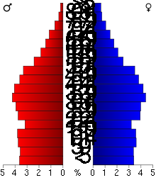 Alterspyramide des Rankin County
Nach der Volkszählung im Jahr 2000 lebten im Rankin County 115.327 Menschen in 42.089 Haushalten und 31.145 Familien. Die Bevölkerungsdichte betrug 57 Personen pro Quadratkilometer. Ethnisch betrachtet setzte sich die Bevölkerung zusammen aus 81,03 Prozent Weißen, 17,12 Prozent Afroamerikanern, 0,16 Prozent amerikanischen Ureinwohnern, 0,66 Prozent Asiaten, 0,02 Prozent Bewohnern aus dem pazifischen Inselraum und 0,41 Prozent aus anderen ethnischen Gruppen; 0,60 Prozent stammten von zwei oder mehr Ethnien ab. 1,32 Prozent der Bevölkerung waren spanischer oder lateinamerikanischer Abstammung, die verschiedenen der genannten Gruppen angehörten.
Von den 42.089 Haushalten hatten 36,7 Prozent Kinder unter 18 Jahren, die mit ihnen lebten. 58,1 Prozent waren verheiratete, zusammenlebende Paare, 12,2 Prozent waren allein erziehende Mütter und 26,0 Prozent waren keine Familien. 21,9 Prozent aller Haushalte waren Singlehaushalte und in 6,2 Prozent lebten Menschen im Alter von 65 Jahren oder darüber. Die durchschnittliche Haushaltsgröße lag bei 2,62 und die durchschnittliche Familiengröße bei 3,07 Personen.
25,9 Prozent der Bevölkerung war unter 18 Jahre alt, 9,1 Prozent zwischen 18 und 24, 32,4 Prozent zwischen 25 und 44, 23,0 Prozent zwischen 45 und 64 Jahre alt und 9,5 Prozent waren 65 Jahre oder älter. Das Durchschnittsalter betrug 35 Jahre. Auf 100 weibliche kamen statistisch 95,6 männliche Personen und auf 100 Frauen im Alter von 18 Jahren oder darüber kamen 92,5 Männer.
Das durchschnittliche Einkommen eines Haushaltes betrug 44.946 US-Dollar (USD), das einer Familie 51.707 USD. Männer hatten ein durchschnittliches Einkommen von 36.097 USD, Frauen 26.096 USD. Das Pro-Kopf-Einkommen lag bei 20.412 USD. Etwa 7,3 Prozent der Familien und 9,5 Prozent der Bevölkerung lebten unterhalb der Armutsgrenze.[6]
Städte und Gemeinden
- Brandon
- Flowood
- Jackson1
- Pearl
- Richland
- Florence
- Pelahatchie
- Puckett
- Fannin
- Johns
- Leesburg
- Piney Woods
- Sandhill
- Star
- Whitfield
1 - überwiegend im Hinds, teilweise im Madison County
Einzelnachweise
- ↑ GNIS-ID: 695781. Abgerufen am 22. Februar 2011 (englisch).
- ↑ U.S. Census Bureau _ Census of Population and Housing Abgerufen am 19. Februar 2011
- ↑ Auszug aus Census.gov Abgerufen am 19. Februar 2011
- ↑ Auszug aus factfinder.census.gov Abgerufen am 18. Februar 2011
- ↑ United States Census 2010 Abgerufen am 5. Mai 2011
- ↑ Rankin County, Mississippi Datenblatt mit den Ergebnissen der Volkszählung im Jahre 2000 bei factfinder.census.gov
Weblinks
-
 Commons: Rankin County, Mississippi – Sammlung von Bildern, Videos und Audiodateien
 - Offizielle Webseite
- Local Governments - Rankin County
- www.city-data.com

Liste der Countys in Mississippi
Adams | Alcorn | Amite | Attala | Benton | Bolivar | Calhoun | Carroll | Chickasaw | Choctaw | Claiborne | Clarke | Clay | Coahoma | Copiah | Covington | DeSoto | Forrest | Franklin | George | Greene | Grenada | Hancock | Harrison | Hinds | Holmes | Humphreys | Issaquena | Itawamba | Jackson | Jasper | Jefferson | Jefferson Davis | Jones | Kemper | Lafayette | Lamar | Lauderdale | Lawrence | Leake | Lee | Leflore | Lincoln | Lowndes | Madison | Marion | Marshall | Monroe | Montgomery | Neshoba | Newton | Noxubee | Oktibbeha | Panola | Pearl River | Perry | Pike | Pontotoc | Prentiss | Quitman | Rankin | Scott | Sharkey | Simpson | Smith | Stone | Sunflower | Tallahatchie | Tate | Tippah | Tishomingo | Tunica | Union | Walthall | Warren | Washington | Wayne | Webster | Wilkinson | Winston | Yalobusha | Yazoo
Wikimedia Foundation.
Schlagen Sie auch in anderen Wörterbüchern nach:
Rankin County — Admin ASC 2 Code Orig. name Rankin County Country and Admin Code US.MS.121 US … World countries Adminstrative division ASC I-II
Rankin County, Mississippi — Infobox U.S. County county = Rankin County state = Mississippi map size = 150 founded = 1828 seat = Brandon largest city wl = Pearl | area total sq mi =806 area land sq mi =775 area water sq mi =32 area percentage = 3.92% census yr = 2000 pop =… … Wikipedia
Rankin County, New South Wales — Infobox Australian cadastral name = Rankin state = New South Wales caption = Location in New South Wales near nw = Killara near n = Landsborough near ne = Yanda near e = Robinson near se = Booroondarra near s = Woore near sw = Werunda near w =… … Wikipedia
Rankin County School District — The Rankin County School District is a public school district based in Brandon, Mississippi (USA).In addition to Brandon, the district serves most of Rankin County, including the communities of Florence, Flowood, Pelahatchie, Puckett, Richland,… … Wikipedia
National Register of Historic Places listings in Rankin County, Mississippi — Location of Rankin County in Mississippi This is a list of the National Register of Historic Places listings in Rankin County, Mississippi. This is intended to be a complete list of the properties and districts on the National Register of… … Wikipedia
Rankin — ist der Familienname folgender Personen: Chris Rankin (* 1983), neuseeländischer Schauspieler Christopher Rankin (1788–1826), US amerikanischer Politiker David Rankin (* 1946), englischer Maler Harry Rankin (* 1920), kanadischer Anwalt,… … Deutsch Wikipedia
Rankin — may refer to: Places *In Australia: ** Division of Rankin, an electoral district in the Australian Federal House of Representatives, in Queensland*In Canada: ** Rankin Inlet, Nunavut ** Rankin Inlet Airport, Nunavut ** Rankin River, Ontario **… … Wikipedia
Rankin, Pennsylvania — Rankin is a borough in Allegheny County, Pennsylvania, 8 miles (13 km) south of Pittsburgh on the Monongahela river. Early in the 20th century, Rankin specialized in manufacturing steel and wire goods. In 1900, 3,775 people lived in Rankin; in… … Wikipedia
Rankin M. Smith, Sr. — Rankin M. Smith, Sr. (October 29, 1924 – October 26, 1997) was an American businessman and philanthropist. A long time resident of Atlanta, Georgia, Smith was very active in the Atlanta community. Smith served as president of the Life Insurance… … Wikipedia
Rankin Wiley, Jr. — Rankin Wiley, Jr. was the Democratic President of the West Virginia Senate from Mason County and served from 1893 to 1895 … Wikipedia
Rankin County


18+
© Academic, 2000-2025
- Kontaktieren Sie uns: Unterstützung, Werbung
Wörterbücher Export, schritte mit PHP, Joomla, Drupal, WordPress, MODx.