- Holmes County (Mississippi)
-
Verwaltung US-Bundesstaat: Mississippi Verwaltungssitz: Lexington Adresse des
Verwaltungssitzes:County Courthouse
P.O. Box 239
Lexington, MS 39095-0239Gründung: 19. Februar 1833 Gebildet aus: Yazoo County Vorwahl: 001 662 Demographie Einwohner: 19.198 (2010) Bevölkerungsdichte: 9,8 Einwohner/km² Geographie Fläche gesamt: 1.979 km² Wasserfläche: 21 km² Karte 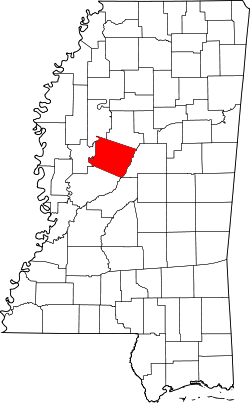
Website: www.holmescountymississippi.com Das Holmes County[2] ist ein County im Bundesstaat Mississippi in den Vereinigten Staaten von Amerika. Bei der Volkszählung im Jahr 2010 hatte das County 19.198 Einwohner und eine Bevölkerungsdichte von 9,8 Einwohnern pro Quadratkilometer. Der Verwaltungssitz (County Seat) ist Lexington, das nach einem Schlachtplatz im Amerikanischen Unabhängigkeitskrieg benannt wurde.
Inhaltsverzeichnis
Geografie
Das County liegt etwas nordwestlich des geografischen Zentrums von Mississippi und hat eine Fläche von 1979 Quadratkilometern, wovon 21 Quadratkilometer Wasserfläche sind. Es grenzt an folgende Countys:
Leflore County Carroll County Humphreys County 
Attala County Yazoo County Geschichte
 D. Holmes
Das Holmes County wurde am 19. Februar 1833 aus Teilen des Yazoo County gebildet. Benannt ist es nach David Holmes (1769-1832), dem letzten Gouverneur (1809-1817) des Mississippi-Territoriums, ersten Gouverneur des Bundesstaates Mississippi (1817-1820) und US-Senator (1820-1825).
Demografische Daten
Historische Einwohnerzahlen Census Einwohner ± in % 1840 9452 — 1850 13.928 50 % 1860 17.791 30 % 1870 19.370 9 % 1880 27.164 40 % 1890 30.970 10 % 1900 36.828 20 % 1910 39.088 6 % 1920 34.513 -10 % 1930 38.534 10 % 1940 39.710 3 % 1950 33.301 -20 % 1960 27.096 -20 % 1970 23.120 -10 % 1980 22.970 -0,6 % 1990 21.604 -6 % 2000 21.609 0,02 % 2010 19.198 -10 % Vor 1900[3] 1900–1990[4] 2000[5] 2010[6] Nach der Volkszählung im Jahr 2000 lebten im Holmes County 21.609 Menschen in 7.314 Haushalten und 5.229 Familien. Die Bevölkerungsdichte betrug 11 Personen pro Quadratkilometer. Ethnisch betrachtet setzte sich die Bevölkerung zusammen aus 20,47 Prozent Weißen, 78,66 Prozent Afroamerikanern, 0,12 Prozent amerikanischen Ureinwohnern, 0,15 Prozent Asiaten und 0,07 Prozent aus anderen ethnischen Gruppen; 0,52 Prozent stammten von zwei oder mehr Ethnien ab. 0,90 Prozent der Bevölkerung waren spanischer oder lateinamerikanischer Abstammung, die verschiedenen der genannten Gruppen angehörten.
Von den 7.314 Haushalten hatten 36,0 Prozent Kinder unter 18 Jahren, die mit ihnen lebten. 34,9 Prozent waren verheiratete, zusammenlebende Paare, 31,2 Prozent waren allein erziehende Mütter und 28,5 Prozent waren keine Familien. 26,3 Prozent aller Haushalte waren Singlehaushalte und in 12,1 Prozent lebten Menschen im Alter von 65 Jahren oder darüber. Die durchschnittliche Haushaltsgröße lag bei 2,86 und die durchschnittliche Familiengröße bei 3,48 Personen.
32,1 Prozent der Bevölkerung war unter 18 Jahre alt, 12,4 Prozent zwischen 18 und 24, 24,8 Prozent zwischen 25 und 44, 18,3 Prozent zwischen 45 und 64 Jahre alt und 12,4 Prozent waren 65 Jahre oder älter. Das Durchschnittsalter betrug 30 Jahre. Auf 100 weibliche kamen statistisch 87,3 männliche Personen und auf 100 Frauen im Alter von 18 Jahren oder darüber kamen 79,3 Männer.
Das durchschnittliche Einkommen eines Haushaltes betrug 17.235 US-Dollar (USD), das einer Familie 21.757 USD. Männer hatten ein durchschnittliches Einkommen von 23.720 USD, Frauen 17.883 USD. Das Pro-Kopf-Einkommen lag bei 10.683 USD. Etwa 35,9 Prozent der Familien und 41,1 Prozent der Bevölkerung lebten unterhalb der Armutsgrenze.[7]
Städte und Gemeinden
- Durant
- Lexington
- Cruger
- Goodman
- Pickens
- Tchula
- West
- Acona
- Coxburg
- Ebenezer
- Egypt
- Franklin
- Howard
- Ituma
- Marcella
- Montgomery
- Owens Wells
- Thornton
- Tolarville
Einzelnachweise
- ↑ Auszug aus dem National Register of Historic Places - Nr. 94001301 Abgerufen am 3. Mai 2011
- ↑ GNIS-ID: 695749. Abgerufen am 22. Februar 2011 (englisch).
- ↑ U.S. Census Bureau _ Census of Population and Housing Abgerufen am 19. Februar 2011
- ↑ Auszug aus Census.gov Abgerufen am 19. Februar 2011
- ↑ Auszug aus factfinder.census.gov Abgerufen am 18. Februar 2011
- ↑ United States Census 2010 Abgerufen am 3. Mai 2011
- ↑ Holmes County, Mississippi Datenblatt mit den Ergebnissen der Volkszählung im Jahre 2000 bei factfinder.census.gov
Weblinks
-
 Commons: Holmes County, Mississippi – Sammlung von Bildern, Videos und Audiodateien
 - Offizielle Webseite
- www.city-data.com

Liste der Countys in Mississippi
Adams | Alcorn | Amite | Attala | Benton | Bolivar | Calhoun | Carroll | Chickasaw | Choctaw | Claiborne | Clarke | Clay | Coahoma | Copiah | Covington | DeSoto | Forrest | Franklin | George | Greene | Grenada | Hancock | Harrison | Hinds | Holmes | Humphreys | Issaquena | Itawamba | Jackson | Jasper | Jefferson | Jefferson Davis | Jones | Kemper | Lafayette | Lamar | Lauderdale | Lawrence | Leake | Lee | Leflore | Lincoln | Lowndes | Madison | Marion | Marshall | Monroe | Montgomery | Neshoba | Newton | Noxubee | Oktibbeha | Panola | Pearl River | Perry | Pike | Pontotoc | Prentiss | Quitman | Rankin | Scott | Sharkey | Simpson | Smith | Stone | Sunflower | Tallahatchie | Tate | Tippah | Tishomingo | Tunica | Union | Walthall | Warren | Washington | Wayne | Webster | Wilkinson | Winston | Yalobusha | Yazoo
Wikimedia Foundation.
Schlagen Sie auch in anderen Wörterbüchern nach:
Holmes County, Mississippi — Infobox U.S. County county = Holmes County state = Mississippi map size = 150 founded = 1833 seat = Lexington | largest city wl = Durant | area total sq mi =764 area land sq mi =756 area water sq mi =8 area percentage = 1.07% census yr = 2000 pop … Wikipedia
National Register of Historic Places listings in Holmes County, Mississippi — Location of Holmes County in Mississippi This is a list of the National Register of Historic Places listings in Holmes County, Mississippi. This is intended to be a complete list of the properties and districts on the National Register of… … Wikipedia
Holmes County — is the name of three counties in the United States:* Holmes County, Florida * Holmes County, Mississippi * Holmes County, Ohio … Wikipedia
Holmes County — Es gibt in den Vereinigten Staaten drei Countys mit dem Namen Holmes County: Holmes County (Florida) Holmes County (Mississippi) Holmes County (Ohio) Diese Seite ist eine Begriffsklärung … Deutsch Wikipedia
Holmes County State Park — is a state park in the U.S. state of Mississippi. It is located off I 55 south of Durant. It is named after Holmes County.The park is located at coord|33|01|44|N|89|54|58|W| GR|3ee also*List of Mississippi state parksReferences *cite web|url=http … Wikipedia
Holmes County School District — is a name shared by several school districts in the United States.* Holmes County School District (Florida) (see List of county school districts in Florida) * Holmes County School District (Mississippi) (see List of school districts in… … Wikipedia
Holmes County School District (Mississippi) — The Holmes County School District is a public school district based in Lexington, Mississippi (USA). The district covers most of Holmes County, although a portion of Durant is served by the Durant Public School District.chools*J.J. McClain High… … Wikipedia
Holmes County — Comté de Holmes Cette page d’homonymie répertorie les différents comtés partageant un même nom. Trois comtés des États Unis portent le nom de comté de Holmes (Holmes County) : le comté de Holmes, situé dans l État de Floride ; le… … Wikipédia en Français
USS Holmes County (LST-836) — The USS Holmes County (LST 836) was an sclass|LST 542|tank landing ship built for the United States Navy during World War II. Named after counties in Florida, Mississippi, and Ohio, she was the only U.S. Naval vessel to bear the name.Originally… … Wikipedia
Humphreys County (Mississippi) — Verwaltung US Bundesstaat: Mississippi Verwaltungssitz: Belzoni Adresse des Verwaltungssitzes: County Courthouse P.O. Box 547 Belzoni, MS 39038 0547 Gründung: 28. März 1918 … Deutsch Wikipedia
Holmes County (Mississippi)


18+
© Academic, 2000-2026
- Kontaktieren Sie uns: Unterstützung, Werbung
Wörterbücher Export, schritte mit PHP, Joomla, Drupal, WordPress, MODx.