- St. Joseph County (Indiana)
-
Verwaltung US-Bundesstaat: Indiana Verwaltungssitz: South Bend Gründung: 1830 Demographie Einwohner: 265.559 (2000) Bevölkerungsdichte: 224,1 Einwohner/km² Geographie Fläche gesamt: 1.194 km² Wasserfläche: 9 km² Karte 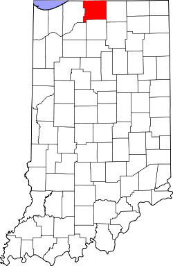
Website: www.stjosephcountyindiana.com St. Joseph County[2] ist ein County im Bundesstaat Indiana der Vereinigten Staaten von Amerika. Die Bevölkerungsstatistik von 2000 weist eine Zahl von 265.559 Einwohnern nach. Der Verwaltungssitz (County Seat) ist South Bend.
Inhaltsverzeichnis
Geografie
Die Gesamtfläche des Bezirks beträgt 1.194 Quadratkilometer. 9 Quadratkilometer dieser Fläche bestehen aus Wasser, das sind 0,79 Prozent.
Demografische Daten
Historische Einwohnerzahlen Census Einwohner ± in % 1830 287 — 1840 6425 2.000 % 1850 10.954 70 % 1860 18.455 70 % 1870 25.322 40 % 1880 33.178 30 % 1890 42.457 30 % 1900 58.881 40 % 1910 84.312 40 % 1920 103.304 20 % 1930 160.033 50 % 1940 161.823 1 % 1950 205.058 30 % 1960 238.614 20 % 1970 245.045 3 % 1980 241.617 -1 % 1990 247.052 2 % 2000 265.559 7 % Vor 1900[3] 1900–1990[4]
Bei der Volkszählung im Jahr 2000 gab es im Bezirk 265.559 Einwohner, 100.743 Haushalte und 66.792 Familien. Die Bevölkerungsdichte betrug 224 Einwohner pro Quadratkilometer.
Die ethnische Zusammensetzung war wie folgt: 82,36 Prozent Weiße, 11,46 Prozent Afro-Amerikaner, 0,35 Prozent amerikanische Ureinwohner, 1,34 Prozent Asiaten, 0,05 Prozent Ozeanier, 2,48 Prozent andere Ethnien, und 1,97 Prozent mit zwei oder mehr Ethnien. 4,73 Prozent der gesamten Bevölkerung waren spanischer oder lateinamerikanischer Abstammung.
Von den 100.743 Haushalten hatten 32,0 Prozent Kinder unter 18 Jahren, 50,0 Prozent bestanden aus verheirateten Paaren, 12,4 Prozent waren Haushalte mit nur einem weiblichen Haushaltsvorstand, und 33,7 Prozent waren Einzelhaushalte.
25,7 Prozent der Bevölkerung waren jünger als 18 Jahre, 11,8 Prozent waren 18-24 Jahre alt, 28,0 Prozent waren 25-44 Jahre alt, 20,9 Prozent waren 45-64, und 13,6 Prozent waren 65 Jahre und älter. Das Durchschnittsalter betrug 34 Jahre. Auf 100 weibliche entfielen 93,2 männliche Einwohner; auf 100 weibliche Einwohner über 18 Jahre entfielen 89,8 männliche Einwohner. [5]
Städte
- Georgetown
- Granger
- Indian Village
- Lakeville
- Mishawaka
- New Carlisle
- North Liberty
- Osceola
- Roseland
- South Bend
- Walkerton
Einzelnachweise
- ↑ Auszug aus dem National Register of Historic Places. Abgerufen am 13. März 2011
- ↑ GNIS-ID: 452855. Abgerufen am 22. Februar 2011 (englisch).
- ↑ U.S. Census Bureau - Census of Population and Housing. Abgerufen am 15. März 2011
- ↑ Auszug aus Census.gov. Abgerufen am 16. Februar 2011
- ↑ St. Joseph County, Indiana, Datenblatt mit den Ergebnissen der Volkszählung im Jahre 2000 bei factfinder.census.gov.

Liste der Countys in Indiana
Adams | Allen | Bartholomew | Benton | Blackford | Boone | Brown | Carroll | Cass | Clark | Clay | Clinton | Crawford | Daviess | DeKalb | Dearborn | Decatur | Delaware | Dubois | Elkhart | Fayette | Floyd | Fountain | Franklin | Fulton | Gibson | Grant | Greene | Hamilton | Hancock | Harrison | Hendricks | Henry | Howard | Huntington | Jackson | Jasper | Jay | Jefferson | Jennings | Johnson | Knox | Kosciusko | LaGrange | Lake | LaPorte | Lawrence | Madison | Marion | Marshall | Martin | Miami | Monroe | Montgomery | Morgan | Newton | Noble | Ohio | Orange | Owen | Parke | Perry | Pike | Porter | Posey | Pulaski | Putnam | Randolph | Ripley | Rush | St. Joseph | Scott | Shelby | Spencer | Starke | Steuben | Sullivan | Switzerland | Tippecanoe | Tipton | Union | Vanderburgh | Vermillion | Vigo | Wabash | Warren | Warrick | Washington | Wayne | Wells | White | Whitley

Wikimedia Foundation.