- Clay County (Indiana)
-
Verwaltung US-Bundesstaat: Indiana Verwaltungssitz: Brazil Adresse des
Verwaltungssitzes:County Courthouse
609 E. National Avenue
Brazil, IN 47834-2670Gründung: 12. Februar 1825 Gebildet aus: Owen County
Putnam County
Sullivan County
Vigo CountyVorwahl: 001 812 Demographie Einwohner: 26.556 (2000) Bevölkerungsdichte: 28,7 Einwohner/km² Geographie Fläche gesamt: 933 km² Wasserfläche: 7 km² Karte 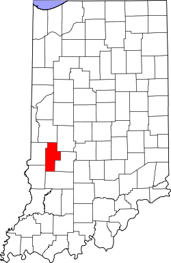
Website: www.claycountyin.org Clay County[1] ist ein County im Bundesstaat Indiana der Vereinigten Staaten von Amerika. Der Verwaltungssitz (County Seat) ist Brazil.
Inhaltsverzeichnis
Geografie
Das County liegt im Südwesten von Indiana, ist im Westen etwa 45 km von Illinois entfernt und hat eine Fläche von 933 Quadratkilometern, wovon 7 Quadratkilometer Wasserfläche sind. Es grenzt im Uhrzeigersinn an folgende Countys: Parke County, Putnam County, Owen County, Greene County, Sullivan County und Vigo County.
Geschichte
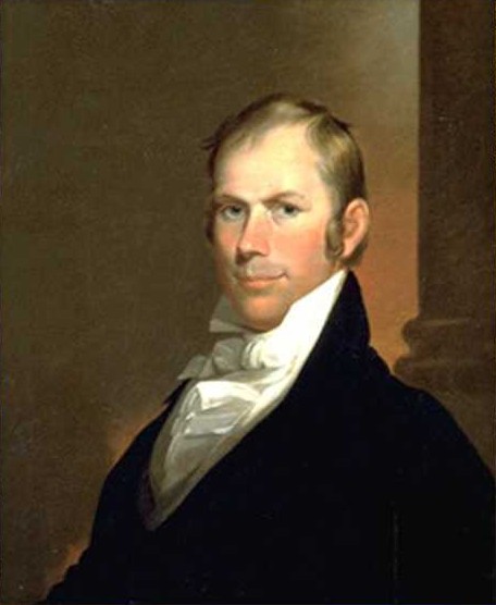
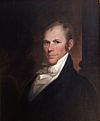 Henry Clay
Clay County wurde am 12. Februar 1825 aus Teilen des Owen County, Putnam County, Sullivan County und Vigo County gebildet. Benannt wurde es nach Henry Clay einem US-amerikanischen Politiker, Mitglied des Repräsentantenhauses, Senator, Außenminister und Gegner der Sklaverei.
Der erste Sitz der Countyverwaltlung war Bowling Green mit dem ersten, 1928 erbauten, Bezirksgericht. Mit dem Bau der National Road (heute US 40) und verschiedenen Eisenbahnlinien rückte die Stadt Brazil an erste Stelle der Erreichbarkeit und 1876 wurde der Sitz der Countyverwaltung verlegt. Das alte Bezirksgerichtsgebäude brannte aus und ein neues wurde in Brazil errichtet. Das nächste wurde 1914 erbaut und ist noch heute in Betrieb.
Demografische Daten
Historische Einwohnerzahlen Census Einwohner ± in % 1830 1616 — 1840 5567 200 % 1850 7944 40 % 1860 12.161 50 % 1870 19.084 60 % 1880 25.854 40 % 1890 30.536 20 % 1900 34.285 10 % 1910 32.535 -5 % 1920 29.447 -9 % 1930 26.479 -10 % 1940 25.365 -4 % 1950 23.918 -6 % 1960 24.207 1 % 1970 23.933 -1 % 1980 24.862 4 % 1990 24.705 -0,6 % 2000 26.556 7 % Vor 1900[2] 1900–1990[3]
Nach der Volkszählung im Jahr 2000 lebten im Clay County 26.556 Menschen in 10.216 Haushalten und 7.437 Familien. Die Bevölkerungsdichte betrug 29 Einwohner pro Quadratkilometer. Ethnisch betrachtet setzte sich die Bevölkerung zusammen aus 98,38 Prozent Weißen, 0,33 Prozent Afroamerikanern, 0,24 Prozent amerikanischen Ureinwohnern, 0,11 Prozent Asiaten, 0,02 Prozent Bewohnern aus dem pazifischen Inselraum und 0,23 Prozent aus anderen ethnischen Gruppen; 0,68 Prozent stammten von zwei oder mehr Ethnien ab. 0,58 Prozent der Bevölkerung waren spanischer oder lateinamerikanischer Abstammung.
 Alterspyramide für das Clay County
Von den 10.216 Haushalten hatten 33,6 Prozent Kinder unter 18 Jahre, die mit ihnen im Haushalt lebten. 59,7 Prozent waren verheiratete, zusammenlebende Paare, 9,4 Prozent waren allein erziehende Mütter und 27,2 Prozent waren keine Familien. 23,8 Prozent waren Singlehaushalte und in 12,3 Prozent lebten Menschen mit 65 Jahren oder darüber. Die Durchschnittshaushaltsgröße betrug 2,57 und die durchschnittliche Familiengröße lag bei 3,03 Personen.
26,1 Prozent der Bevölkerung waren unter 18 Jahre alt, 8,6 Prozent zwischen 18 und 24, 27,8 Prozent zwischen 25 und 44 Jahre. 22,5 Prozent zwischen 45 und 64 und 15,1 Prozent waren 65 Jahre alt oder älter. Das Durchschnittsalter betrug 37 Jahre. Auf 100 weibliche Personen kamen 94,3 männliche Personen. Auf 100 Frauen im Alter von 18 Jahren und darüber kamen 92,1 Männer.
Das jährliche Durchschnittseinkommen eines Haushalts betrug 36.865 USD, das Durchschnittseinkommen der Familien 41.863 USD. Männer hatten ein Durchschnittseinkommen von 31.611 USD, Frauen 21.593 USD. Das Prokopfeinkommen betrug 16.364 USD. 6,4 Prozent der Familien und 8,7 Prozent der Bevölkerung lebten unterhalb der Armutsgrenze. [4]
Siehe auch
Einzelnachweise
- ↑ GNIS-ID: 450341. Abgerufen am 22. Februar 2011 (englisch).
- ↑ U.S. Census Bureau - Census of Population and Housing. Abgerufen am 15. März 2011
- ↑ Auszug aus Census.gov. Abgerufen am 15. Februar 2011
- ↑ Clay County, Indiana, Datenblatt mit den Ergebnissen der Volkszählung im Jahre 2000 bei factfinder.census.gov.

Liste der Countys in Indiana
Adams | Allen | Bartholomew | Benton | Blackford | Boone | Brown | Carroll | Cass | Clark | Clay | Clinton | Crawford | Daviess | DeKalb | Dearborn | Decatur | Delaware | Dubois | Elkhart | Fayette | Floyd | Fountain | Franklin | Fulton | Gibson | Grant | Greene | Hamilton | Hancock | Harrison | Hendricks | Henry | Howard | Huntington | Jackson | Jasper | Jay | Jefferson | Jennings | Johnson | Knox | Kosciusko | LaGrange | Lake | LaPorte | Lawrence | Madison | Marion | Marshall | Martin | Miami | Monroe | Montgomery | Morgan | Newton | Noble | Ohio | Orange | Owen | Parke | Perry | Pike | Porter | Posey | Pulaski | Putnam | Randolph | Ripley | Rush | St. Joseph | Scott | Shelby | Spencer | Starke | Steuben | Sullivan | Switzerland | Tippecanoe | Tipton | Union | Vanderburgh | Vermillion | Vigo | Wabash | Warren | Warrick | Washington | Wayne | Wells | White | Whitley
Wikimedia Foundation.
Schlagen Sie auch in anderen Wörterbüchern nach:
Clay County, Indiana — Coordinates: 39°24′N 87°07′W / 39.40°N 87.11°W / 39.40; 87.11 … Wikipedia
National Register of Historic Places listings in Clay County, Indiana — Location of Clay County in Indiana This is a list of the National Register of Historic Places listings in Clay County, Indiana. This is intended to be a complete list of the properties and districts on the National Register of Historic Places in… … Wikipedia
Dick Johnson Township, Clay County, Indiana — Dick Johnson Township Township Location of Dick Johnson Township in Clay C … Wikipedia
Middlebury, Clay County, Indiana — Middlebury Unincorporated town Clay County s location in Indiana … Wikipedia
Harrison Township, Clay County, Indiana — Infobox Settlement official name = Harrison Township settlement type = Township nickname = motto = imagesize = image caption = image mapsize = map caption = Location of Harrison Township in Clay County mapsize1 = map caption1 = subdivision type … Wikipedia
Lewis Township, Clay County, Indiana — Infobox Settlement official name = Lewis Township settlement type = Township nickname = motto = imagesize = image caption = image mapsize = map caption = Location of Lewis Township in Clay County mapsize1 = map caption1 = subdivision type =… … Wikipedia
Van Buren Township, Clay County, Indiana — Infobox Settlement official name = Van Buren Township settlement type = Township nickname = motto = imagesize = image caption = image mapsize = map caption = Location of Van Buren Township in Clay County mapsize1 = map caption1 = subdivision type … Wikipedia
Cass Township, Clay County, Indiana — Infobox Settlement official name = Cass Township settlement type = Township nickname = motto = imagesize = image caption = image mapsize = map caption = Location of Cass Township in Clay County mapsize1 = map caption1 = subdivision type = Country … Wikipedia
Perry Township, Clay County, Indiana — Infobox Settlement official name = Perry Township settlement type = Township nickname = motto = imagesize = image caption = image mapsize = map caption = Location of Perry Township in Clay County mapsize1 = map caption1 = subdivision type =… … Wikipedia
Posey Township, Clay County, Indiana — Infobox Settlement official name = Posey Township settlement type = Township nickname = motto = imagesize = image caption = image mapsize = map caption = Location of Posey Township in Clay County mapsize1 = map caption1 = subdivision type =… … Wikipedia
Clay County (Indiana)


18+
© Academic, 2000-2025
- Kontaktieren Sie uns: Unterstützung, Werbung
Wörterbücher Export, schritte mit PHP, Joomla, Drupal, WordPress, MODx.