- White County (Indiana)
-
Verwaltung US-Bundesstaat: Indiana Verwaltungssitz: Monticello Adresse des
Verwaltungssitzes:County Courthouse
P.O. Box 260
Monticello, IN 47960-0260Gründung: 1. Februar 1834 Gebildet aus: Carroll County Vorwahl: 001 574 Demographie Einwohner: 25.267 (2000) Bevölkerungsdichte: 19,3 Einwohner/km² Geographie Fläche gesamt: 1.318 km² Wasserfläche: 9 km² Karte 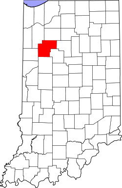
White County[1] ist ein County im Bundesstaat Indiana der Vereinigten Staaten von Amerika. Der Verwaltungssitz (County Seat) ist Monticello.
Inhaltsverzeichnis
Geografie
Das County liegt im mittleren Nordwesten von Indiana und hat eine Fläche von 1318 Quadratkilometern, wovon 9 Quadratkilometer Wasserfläche sind. Es grenzt im Uhrzeigersinn an folgende Countys: Pulaski County, Cass County, Carroll County, Tippecanoe County, Benton County und Jasper County.
Geschichte
White County wurde am 1. Februar 1834 aus Teilen des Carroll County gebildet. Benannt wurde es nach Isaac White, einem Colonel und Helden, gefallen in der Schlacht von Tippecanoe.
Demografische Daten
Historische Einwohnerzahlen Census Einwohner ± in % 1840 1832 — 1850 4761 200 % 1860 8258 70 % 1870 10.554 30 % 1880 13.795 30 % 1890 15.671 10 % 1900 19.138 20 % 1910 17.602 -8 % 1920 17.351 -1 % 1930 15.831 -9 % 1940 17.037 8 % 1950 18.042 6 % 1960 19.709 9 % 1970 20.995 7 % 1980 23.867 10 % 1990 23.265 -3 % 2000 25.267 9 % Vor 1900[2] 1900–1990[3]
Nach der Volkszählung im Jahr 2000 lebten im White County 25.267 Menschen in 9.727 Haushalten und 7.090 Familien. Die Bevölkerungsdichte betrug 19 Einwohner pro Quadratkilometer. Ethnisch betrachtet setzte sich die Bevölkerung zusammen aus 95,20 Prozent Weißen, 0,16 Prozent Afroamerikanern, 0,25 Prozent amerikanischen Ureinwohnern, 0,25 Prozent Asiaten, 0,04 Prozent Bewohnern aus dem pazifischen Inselraum und 3,19 Prozent aus anderen ethnischen Gruppen; 0,92 Prozent stammten von zwei oder mehr Ethnien ab. 5,34 Prozent der Bevölkerung waren spanischer oder lateinamerikanischer Abstammung.
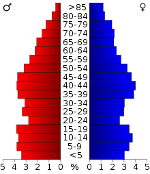 Alterspyramide für das White County
Von den 9.727 Haushalten hatten 32,4 Prozent Kinder unter 18 Jahre, die mit ihnen im Haushalt lebten. 60,4 Prozent waren verheiratete, zusammenlebende Paare, 8,4 Prozent waren allein erziehende Mütter und 27,1 Prozent waren keine Familien. 22,6 Prozent waren Singlehaushalte und in 11,2 Prozent lebten Menschen mit 65 Jahren oder darüber. Die Durchschnittshaushaltsgröße betrug 2,57 und die durchschnittliche Familiengröße lag bei 2,99 Personen.
25,8 Prozent der Bevölkerung waren unter 18 Jahre alt, 7,8 Prozent zwischen 18 und 24, 27,8 Prozent zwischen 25 und 44 Jahre. 23,8 Prozent zwischen 45 und 64 und 14,8 Prozent waren 65 Jahre alt oder älter. Das Durchschnittsalter betrug 38 Jahre. Auf 100 weibliche Personen kamen 96,8 männliche Personen. Auf 100 Frauen im Alter von 18 Jahren und darüber kamen 93,5 Männer.
Das jährliche Durchschnittseinkommen eines Haushalts betrug 40.707 USD, das Durchschnittseinkommen der Familien 46.436 USD. Männer hatten ein Durchschnittseinkommen von 33.232 USD, Frauen 21.431 USD. Das Prokopfeinkommen betrug 18.323 USD. 4,3 Prozent der Familien und 7,0 Prozent der Bevölkerung lebten unterhalb der Armutsgrenze. [4]
Siehe auch
Einzelnachweise
- ↑ GNIS-ID: 450338. Abgerufen am 22. Februar 2011 (englisch).
- ↑ U.S. Census Bureau - Census of Population and Housing. Abgerufen am 15. März 2011
- ↑ Auszug aus Census.gov. Abgerufen am 16. Februar 2011
- ↑ White County, Indiana, Datenblatt mit den Ergebnissen der Volkszählung im Jahre 2000 bei factfinder.census.gov.

Liste der Countys in Indiana
Adams | Allen | Bartholomew | Benton | Blackford | Boone | Brown | Carroll | Cass | Clark | Clay | Clinton | Crawford | Daviess | DeKalb | Dearborn | Decatur | Delaware | Dubois | Elkhart | Fayette | Floyd | Fountain | Franklin | Fulton | Gibson | Grant | Greene | Hamilton | Hancock | Harrison | Hendricks | Henry | Howard | Huntington | Jackson | Jasper | Jay | Jefferson | Jennings | Johnson | Knox | Kosciusko | LaGrange | Lake | LaPorte | Lawrence | Madison | Marion | Marshall | Martin | Miami | Monroe | Montgomery | Morgan | Newton | Noble | Ohio | Orange | Owen | Parke | Perry | Pike | Porter | Posey | Pulaski | Putnam | Randolph | Ripley | Rush | St. Joseph | Scott | Shelby | Spencer | Starke | Steuben | Sullivan | Switzerland | Tippecanoe | Tipton | Union | Vanderburgh | Vermillion | Vigo | Wabash | Warren | Warrick | Washington | Wayne | Wells | White | Whitley
Wikimedia Foundation.
Schlagen Sie auch in anderen Wörterbüchern nach:
White County, Indiana — Infobox U.S. County county = White County state = Indiana map size = 150 founded = 1834 seat = Monticello area total sq mi =509 area land sq mi =505 area water sq mi =4 area percentage = 0.70% census yr = 2000 pop = 25267 density km2 = 19 |… … Wikipedia
National Register of Historic Places listings in White County, Indiana — Location of White County in Indiana This is a list of the National Register of Historic Places listings in White County, Indiana. This is intended to be a complete list of the properties and districts on the National Register of Historic Places… … Wikipedia
Monon Township, White County, Indiana — Monon Township Township Location in White County … Wikipedia
Big Creek Township, White County, Indiana — Infobox Settlement official name = Big Creek Township settlement type = Township nickname = motto = imagesize = image caption = image mapsize = map caption = mapsize1 = map caption1 = subdivision type = Country subdivision name = United States… … Wikipedia
Cass Township, White County, Indiana — Infobox Settlement official name = Cass Township settlement type = Township nickname = motto = imagesize = image caption = image mapsize = map caption = mapsize1 = map caption1 = subdivision type = Country subdivision name = United States… … Wikipedia
Honey Creek Township, White County, Indiana — Infobox Settlement official name = Honey Creek Township settlement type = Township nickname = motto = imagesize = image caption = image mapsize = map caption = mapsize1 = map caption1 = subdivision type = Country subdivision name = United States… … Wikipedia
Jackson Township, White County, Indiana — Infobox Settlement official name = Jackson Township settlement type = Township nickname = motto = imagesize = image caption = image mapsize = map caption = mapsize1 = map caption1 = subdivision type = Country subdivision name = United States… … Wikipedia
Liberty Township, White County, Indiana — Infobox Settlement official name = Liberty Township settlement type = Township nickname = motto = imagesize = image caption = image mapsize = map caption = mapsize1 = map caption1 = subdivision type = Country subdivision name = United States… … Wikipedia
Lincoln Township, White County, Indiana — Infobox Settlement official name = Lincoln Township settlement type = Township nickname = motto = imagesize = image caption = image mapsize = map caption = mapsize1 = map caption1 = subdivision type = Country subdivision name = United States… … Wikipedia
Prairie Township, White County, Indiana — Infobox Settlement official name = Prairie Township settlement type = Township nickname = motto = imagesize = image caption = image mapsize = map caption = mapsize1 = map caption1 = subdivision type = Country subdivision name = United States… … Wikipedia
White County (Indiana)


18+
© Academic, 2000-2025
- Kontaktieren Sie uns: Unterstützung, Werbung
Wörterbücher Export, schritte mit PHP, Joomla, Drupal, WordPress, MODx.