- Franklin County (Indiana)
-
Verwaltung US-Bundesstaat: Indiana Verwaltungssitz: Brookville Adresse des
Verwaltungssitzes:County Courthouse
459 Main Street
Brookville, IN 47012-1484Gründung: 27. November 1810 Gebildet aus: Clark County
Dearborn County
Jefferson CountyVorwahl: 001 765 Demographie Einwohner: 22.151 (2000) Bevölkerungsdichte: 22,2 Einwohner/km² Geographie Fläche gesamt: 1.014 km² Wasserfläche: 14 km² Karte 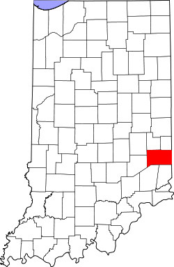
Franklin County[1] ist ein County im US-Bundesstaat Indiana der Vereinigten Staaten von Amerika. Der Verwaltungssitz (County Seat) ist Brookville.
Inhaltsverzeichnis
Geografie
Das County liegt im Südosten von Indiana, grenzt im Osten an Ohio und hat eine Fläche von 1014 Quadratkilometern, wovon 14 Quadratkilometer Wasserfläche sind. Es grenzt im Uhrzeigersinn an folgende Countys: Fayette County, Union County, Butler County und Hamilton County in Ohio, Dearborn County, Ripley County, Decatur County und Rush County.
Geschichte
 Benjamin Franklin
Franklin County wurde am 27. November 1810 aus Teilen des Clark County, des Dearborn County und des Jefferson County gebildet. Benannt wurde es nach Benjamin Franklin, einem nordamerikanischen Verleger, Staatsmann, Schriftsteller, Naturwissenschaftler, Erfinder, Naturphilosoph und Freimaurer.
In Rockdale steht die überdachte historische Snow Hill Covered Bridge. Die Brücke wurde vom National Register of Historic Places am 3. März 1995 mit der Nummer 95000208 aufgenommen.[2]
Demografische Daten
Historische Einwohnerzahlen Census Einwohner ± in % 1820 10.763 — 1830 10.190 -5 % 1840 13.349 30 % 1850 17.968 30 % 1860 19.549 9 % 1870 20.223 3 % 1880 20.092 -0,6 % 1890 18.366 -9 % 1900 16.388 -10 % 1910 15.335 -6 % 1920 14.806 -3 % 1930 14.498 -2 % 1940 14.412 -0,6 % 1950 16.034 10 % 1960 17.015 6 % 1970 16.943 -0,4 % 1980 19.612 20 % 1990 19.580 -0,2 % 2000 22.151 10 % Vor 1900[3] 1900–1990[4]
Nach der Volkszählung im Jahr 2000 lebten im Franklin County 22.151 Menschen in 7.868 Haushalten und 6.129 Familien. Die Bevölkerungsdichte betrug 22 Einwohner pro Quadratkilometer. Ethnisch betrachtet setzte sich die Bevölkerung zusammen aus 99,02 Prozent Weißen, 0,03 Prozent Afroamerikanern, 0,16 Prozent amerikanischen Ureinwohnern, 0,22 Prozent Asiaten, 0,02 Prozent Bewohnern aus dem pazifischen Inselraum und 0,09 Prozent aus anderen ethnischen Gruppen; 0,47 Prozent stammten von zwei oder mehr Ethnien ab. 0,47 Prozent der Bevölkerung waren spanischer oder lateinamerikanischer Abstammung.
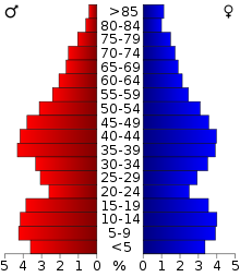 Alterspyramide für das Franklin County
Von den 7.868 Haushalten hatten 37,6 Prozent Kinder unter 18 Jahre, die mit ihnen im Haushalt lebten. 66,0 Prozent waren verheiratete, zusammenlebende Paare, 8,0 Prozent waren allein erziehende Mütter und 22,1 Prozent waren keine Familien. 19,0 Prozent waren Singlehaushalte und in 8,8 Prozent lebten Menschen mit 65 Jahren oder darüber. Die Durchschnittshaushaltsgröße betrug 2,77 und die durchschnittliche Familiengröße lag bei 3,17 Personen.
28,1 Prozent der Bevölkerung waren unter 18 Jahre alt, 7,6 Prozent zwischen 18 und 24, 29,2 Prozent zwischen 25 und 44 Jahre. 22,6 Prozent zwischen 45 und 64 und 12,5 Prozent waren 65 Jahre alt oder älter. Das Durchschnittsalter betrug 36 Jahre. Auf 100 weibliche Personen kamen 99,7 männliche Personen. Auf 100 Frauen im Alter von 18 Jahren und darüber kamen 97,6 Männer.
Das jährliche Durchschnittseinkommen eines Haushalts betrug 43.530 USD, das Durchschnittseinkommen der Familien 50.171 USD. Männer hatten ein Durchschnittseinkommen von 33.998 USD, Frauen 24.516 USD. Das Prokopfeinkommen betrug 18.624 USD. 4,7 Prozent der Familien und 7,1 Prozent der Bevölkerung lebten unterhalb der Armutsgrenze. [5]
Siehe auch
Einzelnachweise
- ↑ GNIS-ID: 450352. Abgerufen am 22. Februar 2011 (englisch).
- ↑ NRIS
- ↑ U.S. Census Bureau - Census of Population and Housing. Abgerufen am 15. März 2011
- ↑ Auszug aus Census.gov. Abgerufen am 15. Februar 2011
- ↑ Franklin County, Indiana, Datenblatt mit den Ergebnissen der Volkszählung im Jahre 2000 bei factfinder.census.gov.
Weblinks
-
 Commons: Franklin County, Indiana – Sammlung von Bildern, Videos und Audiodateien
 - Franklin County (Englisch). Geographic Names Information System. United States Geological Survey. Abgerufen am 2. Februar 2011.

Liste der Countys in Indiana
Adams | Allen | Bartholomew | Benton | Blackford | Boone | Brown | Carroll | Cass | Clark | Clay | Clinton | Crawford | Daviess | DeKalb | Dearborn | Decatur | Delaware | Dubois | Elkhart | Fayette | Floyd | Fountain | Franklin | Fulton | Gibson | Grant | Greene | Hamilton | Hancock | Harrison | Hendricks | Henry | Howard | Huntington | Jackson | Jasper | Jay | Jefferson | Jennings | Johnson | Knox | Kosciusko | LaGrange | Lake | LaPorte | Lawrence | Madison | Marion | Marshall | Martin | Miami | Monroe | Montgomery | Morgan | Newton | Noble | Ohio | Orange | Owen | Parke | Perry | Pike | Porter | Posey | Pulaski | Putnam | Randolph | Ripley | Rush | St. Joseph | Scott | Shelby | Spencer | Starke | Steuben | Sullivan | Switzerland | Tippecanoe | Tipton | Union | Vanderburgh | Vermillion | Vigo | Wabash | Warren | Warrick | Washington | Wayne | Wells | White | Whitley
Wikimedia Foundation.
Schlagen Sie auch in anderen Wörterbüchern nach:
Franklin County, Indiana — Infobox U.S. County county = Franklin County state = Indiana map size = 150 founded = 1811 seat = Brookville area total sq mi =391 area land sq mi =386 area water sq mi =5 area percentage = 1.36% census yr = 2000 pop = 22151 density km2 = 22 |… … Wikipedia
National Register of Historic Places listings in Franklin County, Indiana — Location of Franklin County in Indiana This is a list of the National Register of Historic Places listings in Franklin County, Indiana. This is intended to be a complete list of the properties and districts on the National Register of Historic… … Wikipedia
Metamora Township, Franklin County, Indiana — Metamora Township Township Location of Metamora Township in Franklin Count … Wikipedia
Midway, Franklin County, Indiana — Midway Town … Wikipedia
Ray Township, Franklin County, Indiana — Infobox Settlement official name = Ray Township settlement type = Township nickname = motto = imagesize = image caption = image mapsize = map caption = Location of Ray Township in Franklin County mapsize1 = map caption1 = subdivision type =… … Wikipedia
Highland Township, Franklin County, Indiana — Infobox Settlement official name = Highland Township settlement type = Township nickname = motto = imagesize = image caption = image mapsize = map caption = Location of Highland Township in Franklin County mapsize1 = map caption1 = subdivision… … Wikipedia
Posey Township, Franklin County, Indiana — Infobox Settlement official name = Posey Township settlement type = Township nickname = motto = imagesize = image caption = image mapsize = map caption = Location of Posey Township in Franklin County mapsize1 = map caption1 = subdivision type =… … Wikipedia
Brookville Township, Franklin County, Indiana — Infobox Settlement official name = Brookville Township settlement type = Township nickname = motto = imagesize = image caption = image mapsize = map caption = Location of Brookville Township in Franklin County mapsize1 = map caption1 =… … Wikipedia
Laurel Township, Franklin County, Indiana — Infobox Settlement official name = Laurel Township settlement type = Township nickname = motto = imagesize = image caption = image mapsize = map caption = Location of Laurel Township in Franklin County mapsize1 = map caption1 = subdivision type … Wikipedia
Blooming Grove Township, Franklin County, Indiana — Infobox Settlement official name = Blooming Grove Township settlement type = Township nickname = motto = imagesize = image caption = image mapsize = map caption = Location of Blooming Grove Township in Franklin County mapsize1 = map caption1 =… … Wikipedia
Franklin County (Indiana)


18+
© Academic, 2000-2025
- Kontaktieren Sie uns: Unterstützung, Werbung
Wörterbücher Export, schritte mit PHP, Joomla, Drupal, WordPress, MODx.