- Wallington (England)
-
London Borough of Sutton 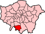
Lage in Greater LondonStatus London Borough Region Greater London Verwaltungssitz Sutton Fläche 43,85 km² (310.) Einwohner (2007) 185.900 (80.) ONS-Code 00BF Website www.sutton.gov.uk London Borough of Sutton [ˈsʌtn̩] ist ein Stadtbezirk von London und liegt im Süden der Stadt. Er wurde 1965 bei der Gründung von Greater London aus den Gemeinden Beddington, Sutton and Cheam und Carshalton gebildet, welche damals zur Grafschaft Surrey gehörten.
Minden und der Berliner Bezirk Charlottenburg-Wilmersdorf sind Partnerstädte. Die Bevölkerung setzt sich zusammen aus 89,2 % Weißen, 4,7 % Südasiaten und 2,6 % Schwarzen.
Stadtteile
- Beddington
- Beddington Corner
- Belmont
- Benhilton
- Carshalton
- Carshalton Beeches
- Carshalton on the Hill
- Cheam
- Hackbridge
- Little Woodcote
- North Cheam
- Rosehill
- St. Helier
- South Beddington
- Sutton
- The Wrythe
- Wallington
- Worcester Park
Persönlichkeiten
- Jeff Beck - Gitarrist
- Paul Greengrass - Regisseur und Autor
- Phyllis King - Tennisspielerin
- Peter Ladefoged - Phonetiker
- Peter Manley - Dartspieler
- Robbie McIntosh - Rockgitarrist
Weblinks
Stadtbezirke von LondonBarking and Dagenham | Barnet | Bexley | Brent | Bromley | Camden | City of London | City of Westminster | Croydon | Ealing | Enfield | Greenwich | Hackney | Hammersmith and Fulham | Haringey | Harrow | Havering | Hillingdon | Hounslow | Islington | Kensington and Chelsea | Kingston | Lambeth | Lewisham | Merton | Newham | Redbridge | Richmond | Southwark | Sutton | Tower Hamlets | Waltham Forest | Wandsworth
Sonstige Einteilung: Greater London | Inner London | Outer London | County of London

Wikimedia Foundation.