- Williams County (Ohio)
-
Verwaltung US-Bundesstaat: Ohio Verwaltungssitz: Bryan Adresse des
Verwaltungssitzes:County Courthouse
One Courthouse Square
Bryan, OH 43506-1791Gründung: 12. Februar 1820 Gebildet aus: Darke County Vorwahl: 001 419 Demographie Einwohner: 38.688 (2005) Bevölkerungsdichte: 35,4 Einwohner/km² Geographie Fläche gesamt: 1.096 km² Wasserfläche: 3 km² Karte 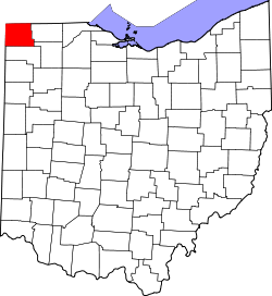
Website: www.co.williams.oh.us Williams County[2] ist ein County im Bundesstaat Ohio der Vereinigten Staaten von Amerika. Der Verwaltungssitz (County Seat) ist Bryan.
Inhaltsverzeichnis
Geografie
Das County liegt im äußersten Nordwesten von Ohio, grenzt im Norden an Michigan, im Westen an Indiana und hat eine Fläche von 1096 Quadratkilometern, wovon 3 Quadratkilometer Wasserfläche sind. Es grenzt im Uhrzeigersinn an folgende Countys: Hillsdale County (Michigan), Fulton County, Henry County, Defiance County, De Kalb County (Indiana) und Steuben County (Indiana).
Geschichte
Williams County wurde am 12. Februar 1820 aus Teilen des Darke County gebildet. Benannt wurde es nach David Williams, einem Offizier der Kontinentalarmee im Amerikanischen Unabhängigkeitskrieg.
Demografische Daten
Historische Einwohnerzahlen Census Einwohner ± in % 1830 387 — 1840 4465 1.000 % 1850 8018 80 % 1860 16.633 100 % 1870 20.991 30 % 1880 23.821 10 % 1890 24.897 5 % 1900 24.953 0,2 % 1910 25.198 1 % 1920 24.627 -2 % 1930 24.316 -1 % 1940 25.510 5 % 1950 26.202 3 % 1960 29.968 10 % 1970 33.669 10 % 1980 36.369 8 % 1990 36.956 2 % 2000 39.188 6 % Vor 1900[3] 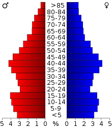 Alterspyramide für das Williams County
Nach der Volkszählung im Jahr 2000 lebten im Williams County 39.188 Menschen in 15.105 Haushalten und 10.664 Familien. Die Bevölkerungsdichte betrug 36 Einwohner pro Quadratkilometer. Ethnisch betrachtet setzte sich die Bevölkerung zusammen aus 96,51 Prozent Weißen, 0,72 Prozent Afroamerikanern, 0,23 Prozent amerikanischen Ureinwohnern, 0,52 Prozent Asiaten, 0,01 Prozent Bewohnern aus dem pazifischen Inselraum und 1,19 Prozent aus anderen ethnischen Gruppen; 0,83 Prozent stammten von zwei oder mehr Ethnien ab. 2,68 Prozent der Bevölkerung waren spanischer oder lateinamerikanischer Abstammung.
Von den 15.105 Haushalten hatten 33,3 Prozent Kinder und Jugendliche unter 18 Jahre, die bei ihnen lebten. 57,5 Prozent waren verheiratete, zusammenlebende Paare, 9,0 Prozent waren allein erziehende Mütter, 29,4 Prozent waren keine Familien, 24,9 Prozent waren Singlehaushalte und in 10,5 Prozent lebten Menschen im Alter von 65 Jahren oder darüber. Die Durchschnittshaushaltsgröße betrug 2,52 und die durchschnittliche Familiengröße lag bei 3,00 Personen.
Auf das gesamte County bezogen setzte sich die Bevölkerung zusammen aus 26,2 Prozent Einwohnern unter 18 Jahren, 8,3 Prozent zwischen 18 und 24 Jahren, 28,7 Prozent zwischen 25 und 44 Jahren, 22,9 Prozent zwischen 45 und 64 Jahren und 13,9 Prozent waren 65 Jahre alt oder darüber. Das Durchschnittsalter betrug 37 Jahre. Auf 100 weibliche Personen kamen 98,7 männliche Personen. Auf 100 Frauen im Alter von 18 Jahren oder darüber kamen statistisch 96,4 Männer.
Das jährliche Durchschnittseinkommen eines Haushalts betrug 40.735 USD, das Durchschnittseinkommen der Familien betrug 47.398 USD. Männer hatten ein Durchschnittseinkommen von 33.476 USD, Frauen 22.136 USD. Das Prokopfeinkommen betrug 18.441 USD. 3,9 Prozent der Familien und 6,0 Prozent der Bevölkerung lebten unterhalb der Armutsgrenze. Davon waren 6,2 Prozent Kinder oder Jugendliche unter 18 Jahre und 6,9 Prozent waren Menschen über 65 Jahre. [6]
Orte
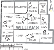 Verwaltungsgliederung des Williams Countys
City
Villages
- Blakeslee
- Edgerton
- Edon
- Holiday City
- Montpelier
- Pioneer
- Stryker
- West Unity
Townships
- Brady
- Bridgewater
- Center
- Florence
- Jefferson
- Madison
- Mill Creek
- Northwest
- Pulaski
- St. Joseph
- Springfield
- Superior
Andere Ortschaften
- Ainger
- Alvordton
- Berlin
- Bridgewater Center
- Columbia
- Cooney
- Franklin Junction
- Hallock
- Hamer
- Hillcrest
- Kunkle
- Lock Port
- Melbern
- Mina
- Nettle Lake
- West Jefferson
- Williams Center
Einzelnachweise
- ↑ Auszug aus dem National Register of Historic Places. Abgerufen am 13. März 2011
- ↑ Williams County im Geographic Names Information System des United States Geological Survey. Abgerufen am 22. Februar 2011
- ↑ U.S. Census Bureau _ Census of Population and Housing. Abgerufen am 17. Februar 2011
- ↑ Auszug aus Census.gov. Abgerufen am 21. Februar 2011
- ↑ Auszug aus factfinder.census.gov Abgerufen am 21. Februar 2011
- ↑ Williams County, Ohio, Datenblatt mit den Ergebnissen der Volkszählung im Jahre 2000 bei factfinder.census.gov.

Liste der Countys in Ohio
Adams | Allen | Ashland | Ashtabula | Athens | Auglaize | Belmont | Brown | Butler | Carroll | Champaign | Clark | Clermont | Clinton | Columbiana | Coshocton | Crawford | Cuyahoga | Darke | Defiance | Delaware | Erie | Fairfield | Fayette | Franklin | Fulton | Gallia | Geauga | Greene | Guernsey | Hamilton | Hancock | Hardin | Harrison | Henry | Highland | Hocking | Holmes | Huron | Jackson | Jefferson | Knox | Lake | Lawrence | Licking | Logan | Lorain | Lucas | Madison | Mahoning | Marion | Medina | Meigs | Mercer | Miami | Monroe | Montgomery | Morgan | Morrow | Muskingum | Noble | Ottawa | Paulding | Perry | Pickaway | Pike | Portage | Preble | Putnam | Richland | Ross | Sandusky | Scioto | Seneca | Shelby | Stark | Summit | Trumbull | Tuscarawas | Union | Van Wert | Vinton | Warren | Washington | Wayne | Williams | Wood | Wyandot
Wikimedia Foundation.
Schlagen Sie auch in anderen Wörterbüchern nach:
Williams County, Ohio — Infobox U.S. County county = Williams County state = Ohio founded year = 1820cite web|url =http://www.odod.state.oh.us/research/FILES/S0/Williams.pdf |title = Ohio County Profiles: Williams County |accessdate = 2007 04 28 |publisher = Ohio… … Wikipedia
National Register of Historic Places listings in Williams County, Ohio — Location of Williams County in Ohio This is a list of the National Register of Historic Places listings in Williams County, Ohio. It is intended to be a complete list of the properties and districts on the National Register of Historic Places in… … Wikipedia
Northwest Township, Williams County, Ohio — Northwest Township, Ohio Township Location of Northwest Township in Williams County … Wikipedia
Mill Creek Township, Williams County, Ohio — Mill Creek Township, Ohio Township Location of Mill Creek Township in Williams County … Wikipedia
Center Township, Williams County, Ohio — Infobox Settlement official name = Center Township, Ohio settlement type = Township nickname = motto = imagesize = image caption = image mapsize = 250x200px map caption = Location of Center Township in Williams County mapsize1 = map caption1 =… … Wikipedia
Springfield Township, Williams County, Ohio — Infobox Settlement official name = Springfield Township, Ohio settlement type = Township nickname = motto = imagesize = image caption = image mapsize = 250x200px map caption = Location of Springfield Township in Williams County mapsize1 = map… … Wikipedia
Jefferson Township, Williams County, Ohio — Infobox Settlement official name = Jefferson Township, Ohio settlement type = Township nickname = motto = imagesize = image caption = image mapsize = 250x200px map caption = Location of Jefferson Township in Williams County mapsize1 = map… … Wikipedia
Pulaski Township, Williams County, Ohio — Infobox Settlement official name = Pulaski Township, Ohio settlement type = Township nickname = motto = imagesize = image caption = image mapsize = map caption = mapsize1 = map caption1 = subdivision type = Country subdivision name = United… … Wikipedia
St. Joseph Township, Williams County, Ohio — Infobox Settlement official name = St. Joseph Township, Ohio settlement type = Township nickname = motto = imagesize = image caption = image mapsize = 250x200px map caption = Location of St. Joseph Township in Williams County mapsize1 = map… … Wikipedia
Brady Township, Williams County, Ohio — Infobox Settlement official name = Brady Township, Ohio settlement type = Township nickname = motto = imagesize = image caption = image mapsize = 250x200px map caption = Location of Brady Township in Williams County mapsize1 = map caption1 =… … Wikipedia
Williams County (Ohio)


18+
© Academic, 2000-2025
- Kontaktieren Sie uns: Unterstützung, Werbung
Wörterbücher Export, schritte mit PHP, Joomla, Drupal, WordPress, MODx.