- Jefferson County (Ohio)
-
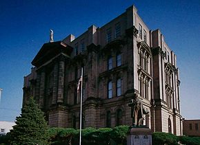 Das Jefferson County Courthouse in Steubenville
Verwaltung US-Bundesstaat: Ohio Verwaltungssitz: Steubenville Adresse des
Verwaltungssitzes:County Courthouse
301 Market Street
Steubenville, OH 43952-2187Gründung: 27. Juli 1797 Gebildet aus: Washington County Vorwahl: 001 740 Demographie Einwohner: 69.709 (2010) Bevölkerungsdichte: 65,7 Einwohner/km² Geographie Fläche gesamt: 1.064 km² Wasserfläche: 3 km² Karte 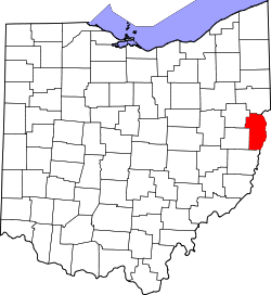
Website: www.jeffersoncountyoh.com Das Jefferson County[1] ist ein County im US-amerikanischen Bundesstaat Ohio. Bei der Volkszählung im Jahr 2010 hatte das County 69.709 Einwohner und eine Bevölkerungsdichte von 65,7 Einwohnern pro Quadratkilometer. Der Verwaltungssitz (County Seat) ist Steubenville.[2]
Inhaltsverzeichnis
Geografie
Das County liegt im äußersten Osten von Ohio und grenzt an West Virginia, dessen Grenze durch den Ohio River gebildet wird. Es hat eine Fläche von 1.064 Quadratkilometern, wovon 3 Quadratkilometer Wasserfläche sind. An das Jefferson County grenzen folgende Countys:
Carroll County Columbiana County Hancock County
(West Virginia)
Brooke County
(West Virginia)Harrison County Belmont County Ohio County
(West Virginia)Geschichte
 Jefferson
Das Jefferson County wurde am 27. Juli 1797 aus Teilen des Washington County gebildet. Benannt wurde es nach Thomas Jefferson (1743-1826), dem dritten Präsidenten der Vereinigten Staaten (1801-1809).
Demografische Daten
Historische Einwohnerzahlen Census Einwohner ± in % 1800 8766 — 1810 17.260 100 % 1820 18.531 7 % 1830 22.489 20 % 1840 25.030 10 % 1850 29.133 20 % 1860 26.115 -10 % 1870 29.188 10 % 1880 33.018 10 % 1890 39.415 20 % 1900 44.357 10 % 1910 65.423 50 % 1920 77.580 20 % 1930 88.307 10 % 1940 98.129 10 % 1950 96.495 -2 % 1960 99.201 3 % 1970 96.193 -3 % 1980 91.564 -5 % 1990 80.298 -10 % 2000 73.894 -8 % 2010 69.709 -6 % Vor 1900[3] 1900–1990[4] 2000[5] 2010[6] Nach der Volkszählung im Jahr 2010 lebten im Jefferson County 69.709 Menschen in 29.481 Haushalten. Die Bevölkerungsdichte betrug 65,7 Einwohner pro Quadratkilometer.
Ethnisch betrachtet setzte sich die Bevölkerung zusammen aus 91,9 Prozent Weißen, 5,6 Prozent Afroamerikanern, 0,1 Prozent amerikanischen Ureinwohnern, 0.4 Prozent Asiaten sowie aus anderen ethnischen Gruppen; 1,7 Prozent stammten von zwei oder mehr Ethnien ab. Unabhängig von der ethnischen Zugehörigkeit waren 1,1 Prozent der Bevölkerung spanischer oder lateinamerikanischer Abstammung.
In den 29.481 Haushalten lebten statistisch je 2,23 Personen.
20,2 Prozent der Bevölkerung waren unter 18 Jahre alt, 61,5 Prozent waren zwischen 18 und 64 und 18,3 Prozent waren 65 Jahre oder älter. 52,0 Prozent der Bevölkerung war weiblich.
Das jährliche Durchschnittseinkommen eines Haushalts lag bei 37.057 USD. Das Pro - Kopf - Einkommen betrug 20.518 USD. 17,6 Prozent der Einwohner lebten unterhalb der Armutsgrenze.[7]
Einzelnachweise
- ↑ Jefferson County im Geographic Names Information System des United States Geological Survey Abgerufen am 22. Februar 2011
- ↑ National Association of Counties Abgerufen am 1. November 2011
- ↑ U.S. Census Bureau _ Census of Population and Housing Abgerufen am 17. Februar 2011
- ↑ Auszug aus Census.gov Abgerufen am 21. Februar 2011
- ↑ Auszug aus factfinder.census.gov Abgerufen am 21. Februar 2011
- ↑ United States Census 2010 Abgerufen am 1. November 2011
- ↑ U.S. Census Buero, State & County QuickFacts - Jefferson County Abgerufen am 1. November 2011
Städte und Gemeinden
- Adena1
- Amsterdam
- Bergholz
- Bloomingdale
- Dillonvale
- Empire
- Irondale
- Mingo Junction
- Mount Pleasant
- New Alexandria
- Rayland
- Richmond
- Smithfield
- Stratton
- Tiltonsville
- Wintersville
- Yorkville2
1 - teilweise im Harrison County
2 - teilweise im Belmont CountyWeblinks
-
 Commons: Jefferson County, Ohio – Sammlung von Bildern, Videos und Audiodateien
 - Offizielle Webseite
- U.S. Census Buero, State & County QuickFacts - Jefferson County
- Yahoo Bildersuche - Jefferson County
- www.city-data.com - Jefferson County

Liste der Countys in Ohio
Adams | Allen | Ashland | Ashtabula | Athens | Auglaize | Belmont | Brown | Butler | Carroll | Champaign | Clark | Clermont | Clinton | Columbiana | Coshocton | Crawford | Cuyahoga | Darke | Defiance | Delaware | Erie | Fairfield | Fayette | Franklin | Fulton | Gallia | Geauga | Greene | Guernsey | Hamilton | Hancock | Hardin | Harrison | Henry | Highland | Hocking | Holmes | Huron | Jackson | Jefferson | Knox | Lake | Lawrence | Licking | Logan | Lorain | Lucas | Madison | Mahoning | Marion | Medina | Meigs | Mercer | Miami | Monroe | Montgomery | Morgan | Morrow | Muskingum | Noble | Ottawa | Paulding | Perry | Pickaway | Pike | Portage | Preble | Putnam | Richland | Ross | Sandusky | Scioto | Seneca | Shelby | Stark | Summit | Trumbull | Tuscarawas | Union | Van Wert | Vinton | Warren | Washington | Wayne | Williams | Wood | Wyandot
Wikimedia Foundation.
Schlagen Sie auch in anderen Wörterbüchern nach:
Jefferson County, Ohio — Location in the state of Ohio … Wikipedia
National Register of Historic Places listings in Jefferson County, Ohio — Location of Jefferson County in Ohio This is a list of the National Register of Historic Places listings in Jefferson County, Ohio. This is intended to be a complete list of the properties and districts on the National Register of Historic Places … Wikipedia
Cross Creek Township, Jefferson County, Ohio — Cross Creek Township, Ohio Township Municipalities and townships of Jefferson Co … Wikipedia
Mount Pleasant Township, Jefferson County, Ohio — Mount Pleasant Township, Ohio Township Municipalities and townships of Jefferson … Wikipedia
Island Creek Township, Jefferson County, Ohio — Infobox Settlement official name = Island Creek Township, Ohio settlement type = Township nickname = motto = imagesize = image caption = image mapsize = 250x200px map caption = Municipalities and townships of Jefferson County. mapsize1 = map… … Wikipedia
Warren Township, Jefferson County, Ohio — Infobox Settlement official name = Warren Township, Ohio settlement type = Township nickname = motto = imagesize = image caption = image mapsize = 250x200px map caption = Municipalities and townships of Jefferson County. mapsize1 = map caption1 … Wikipedia
Steubenville Township, Jefferson County, Ohio — Infobox Settlement official name = Steubenville Township, Ohio settlement type = Township nickname = motto = imagesize = image caption = image mapsize = 250x200px map caption = Municipalities and townships of Jefferson County. mapsize1 = map… … Wikipedia
Dillonvale, Jefferson County, Ohio — Dillonvale, Ohio Village Location of Dillonvale, Jefferson County, Ohio … Wikipedia
Saline Township, Jefferson County, Ohio — Infobox Settlement official name = Saline Township, Ohio settlement type = Township nickname = motto = imagesize = image caption = image mapsize = 250x200px map caption = Municipalities and townships of Jefferson County. mapsize1 = map caption1 … Wikipedia
Knox Township, Jefferson County, Ohio — Infobox Settlement official name = Knox Township, Ohio settlement type = Township nickname = motto = imagesize = image caption = image mapsize = 250x200px map caption = Municipalities and townships of Jefferson County. mapsize1 = map caption1 =… … Wikipedia
Jefferson County (Ohio)


18+
© Academic, 2000-2026
- Kontaktieren Sie uns: Unterstützung, Werbung
Wörterbücher Export, schritte mit PHP, Joomla, Drupal, WordPress, MODx.