- Butler County (Ohio)
-
Verwaltung US-Bundesstaat: Ohio Verwaltungssitz: Hamilton Adresse des
Verwaltungssitzes:County Administration Bldg.
315 High Street
Hamilton, OH 45011-6056Gründung: 24. März 1803 Gebildet aus: Hamilton County Vorwahl: 001 513 Demographie Einwohner: 350.412 (2005) Bevölkerungsdichte: 289,6 Einwohner/km² Geographie Fläche gesamt: 1.218 km² Wasserfläche: 8 km² Karte 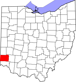
Website: www.butlercountyohio.org Butler County[2] ist ein County im Bundesstaat Ohio der Vereinigten Staaten von Amerika. Der Verwaltungssitz (County Seat) ist Hamilton.
Inhaltsverzeichnis
Geografie
Das County liegt fast im äußersten Südwesten von Ohio, grenzt im Westen an Indiana und hat eine Fläche von 1218 Quadratkilometern, wovon 8 Quadratkilometer Wasserfläche sind. Es grenzt im Uhrzeigersinn an folgende Countys: Preble County, Montgomery County, Warren County, Hamilton County, Dearborn County (Indiana), Franklin County (Indiana) und Union County (Indiana).
Geschichte
Butler County wurde am 24. März 1803 aus Teilen des Hamilton County gebildet. Benannt wurde es nach Richard Butler, einem General im Amerikanischen Unabhängigkeitskrieg.
Demografische Daten
Historische Einwohnerzahlen Census Einwohner ± in % 1810 11.150 — 1820 21.746 100 % 1830 27.142 20 % 1840 28.173 4 % 1850 30.789 9 % 1860 35.840 20 % 1870 39.912 10 % 1880 42.579 7 % 1890 48.597 10 % 1900 56.870 20 % 1910 70.271 20 % 1920 87.025 20 % 1930 114.084 30 % 1940 120.249 5 % 1950 147.203 20 % 1960 199.076 40 % 1970 226.207 10 % 1980 258.787 10 % 1990 291.479 10 % 2000 332.807 10 % Vor 1900[3] 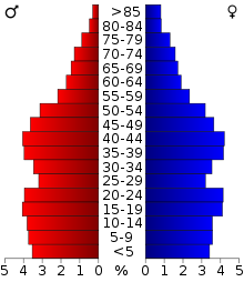 Alterspyramide für das Butler County
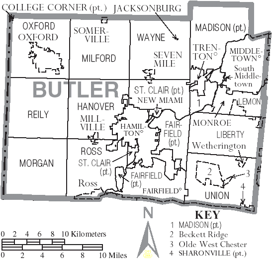
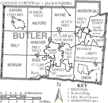 Karte des Butler County
Nach der Volkszählung im Jahr 2000 lebten im Butler County 332.807 Menschen in 123.082 Haushalten und 87.880 Familien. Die Bevölkerungsdichte betrug 275 Einwohner pro Quadratkilometer. Ethnisch betrachtet setzte sich die Bevölkerung zusammen aus 91,20 Prozent Weißen, 5,27 Prozent Afroamerikanern, 0,21 Prozent Indianern, 1,55 Prozent Asiatischen Amerikanern, 0,03 Prozent Pazifischen Insulanern und 0,62 Prozent aus anderen ethnischen Gruppen; 1,13 Prozent stammten von zwei oder mehr Ethnien ab. 1,43 Prozent der Bevölkerung waren Hispanics oder Latinos.
Von den 123.082 Haushalten hatten 35,5 Prozent Kinder und Jugendliche unter 18 Jahre, die bei ihnen lebten. 57,0 Prozent waren verheiratete, zusammenlebende Paare, 10,7 Prozent waren allein erziehende Mütter, 28,6 Prozent waren keine Familien, 22,7 Prozent waren Singlehaushalte und in 7,6 Prozent lebten Menschen im Alter von 65 Jahren oder darüber. Die Durchschnittshaushaltsgröße betrug 2,61 und die durchschnittliche Familiengröße lag bei 3,07 Personen.
Auf das gesamte County bezogen setzte sich die Bevölkerung zusammen aus 25,9 Prozent Einwohnern unter 18 Jahren, 11,9 Prozent zwischen 18 und 24 Jahren, 29,8 Prozent zwischen 25 und 44 Jahren, 21,7 Prozent zwischen 45 und 64 Jahren und 10,7 Prozent waren 65 Jahre alt oder darüber. Das Durchschnittsalter betrug 34 Jahre. Auf 100 weibliche Personen kamen 95,3 männliche Personen. Auf 100 Frauen im Alter von 18 Jahren oder darüber kamen statistisch 92,2 Männer.
Das jährliche Durchschnittseinkommen eines Haushalts betrug 47.885 USD, das Durchschnittseinkommen der Familien betrug 57.513 USD. Männer hatten ein Durchschnittseinkommen von 42.052 USD, Frauen 27.602 USD. Das Prokopfeinkommen betrug 22.076 USD. 5,4 Prozent der Familien und 8,7 Prozent der Bevölkerung lebten unterhalb der Armutsgrenze. Davon waren 9,1 Prozent Kinder oder Jugendliche unter 18 Jahre und 7,0 Prozent waren Menschen über 65 Jahre. [6]
Orte in Butler County
Städte
- Sharonville
- Trenton
Dörfer
- College Corner
- Jacksonburg
- Millville
- New Miami
- Seven Mile
- Somerville
Census-designated places
- Beckett Ridge
- Olde West Chester
- Ross
- South Middletown
- Wetherington
Townships
Einzelnachweise
- ↑ Auszug aus dem National Register of Historic Places. Abgerufen am 13. März 2011
- ↑ Butler County im Geographic Names Information System des United States Geological Survey. Abgerufen am 22. Februar 2011
- ↑ U.S. Census Bureau _ Census of Population and Housing. Abgerufen am 17. Februar 2011
- ↑ Auszug aus Census.gov. Abgerufen am 21. Februar 2011
- ↑ Auszug aus factfinder.census.gov Abgerufen am 21. Februar 2011
- ↑ Butler County, Ohio, Datenblatt mit den Ergebnissen der Volkszählung im Jahre 2000 bei factfinder.census.gov.
Weblinks
 Commons: Butler County, Ohio – Sammlung von Bildern, Videos und Audiodateien
Liste der Countys in Ohio
Adams | Allen | Ashland | Ashtabula | Athens | Auglaize | Belmont | Brown | Butler | Carroll | Champaign | Clark | Clermont | Clinton | Columbiana | Coshocton | Crawford | Cuyahoga | Darke | Defiance | Delaware | Erie | Fairfield | Fayette | Franklin | Fulton | Gallia | Geauga | Greene | Guernsey | Hamilton | Hancock | Hardin | Harrison | Henry | Highland | Hocking | Holmes | Huron | Jackson | Jefferson | Knox | Lake | Lawrence | Licking | Logan | Lorain | Lucas | Madison | Mahoning | Marion | Medina | Meigs | Mercer | Miami | Monroe | Montgomery | Morgan | Morrow | Muskingum | Noble | Ottawa | Paulding | Perry | Pickaway | Pike | Portage | Preble | Putnam | Richland | Ross | Sandusky | Scioto | Seneca | Shelby | Stark | Summit | Trumbull | Tuscarawas | Union | Van Wert | Vinton | Warren | Washington | Wayne | Williams | Wood | Wyandot
Wikimedia Foundation.
Schlagen Sie auch in anderen Wörterbüchern nach:
Butler County, Ohio — Infobox U.S. County county = Butler County state = Ohio founded = May 1 1803cite web|url = http://www.odod.state.oh.us/research/FILES/S0/Butler.pdf |title = Ohio County Profiles: Butler County |accessdate = 2007 04 28 |publisher = Ohio Department … Wikipedia
Oxford Township, Butler County, Ohio — Oxford Township, Ohio Township Municipalities and townships of Butler County … Wikipedia
Liberty Township, Butler County, Ohio — Infobox Settlement official name = Liberty Township, Butler County, Ohio settlement type = Township nickname = motto = imagesize = image caption = image mapsize = 250px map caption = Municipalities and townships of Butler County. mapsize1 = 250px … Wikipedia
Milford Township, Butler County, Ohio — Township Municipalities and townships of Butler … Wikipedia
Morgan Township, Butler County, Ohio — Morgan Township, Ohio Township Municipalities and townships of Butler County … Wikipedia
Lemon Township, Butler County, Ohio — Infobox Settlement official name = Lemon Township, Butler County, Ohio settlement type = Township nickname = motto = imagesize = 250px image caption = Countryside in Lemon Township image mapsize = 250px map caption = Municipalities and townships… … Wikipedia
Madison Township, Butler County, Ohio — Infobox Settlement official name = Madison Township, Ohio settlement type = Township nickname = motto = imagesize = image caption = image mapsize = 250x200px map caption = Municipalities and townships of Butler County. mapsize1 = map caption1 =… … Wikipedia
Ross Township, Butler County, Ohio — Infobox Settlement official name = Ross Township, Ohio settlement type = Township nickname = motto = imagesize = image caption = image mapsize = 250x200px map caption = Municipalities and townships of Butler County. mapsize1 = map caption1 =… … Wikipedia
Reily Township, Butler County, Ohio — Infobox Settlement official name = Reily Township, Ohio settlement type = Township nickname = motto = imagesize = image caption = image mapsize = 250x200px map caption = Municipalities and townships of Butler County. mapsize1 = map caption1 =… … Wikipedia
St. Clair Township, Butler County, Ohio — Infobox Settlement official name = St. Clair Township, Ohio settlement type = Township nickname = motto = imagesize = image caption = image mapsize = 250x200px map caption = Municipalities and townships of Butler County. mapsize1 = map caption1 … Wikipedia
Butler County (Ohio)


18+
© Academic, 2000-2026
- Kontaktieren Sie uns: Unterstützung, Werbung
Wörterbücher Export, schritte mit PHP, Joomla, Drupal, WordPress, MODx.