- Hancock County (Ohio)
-
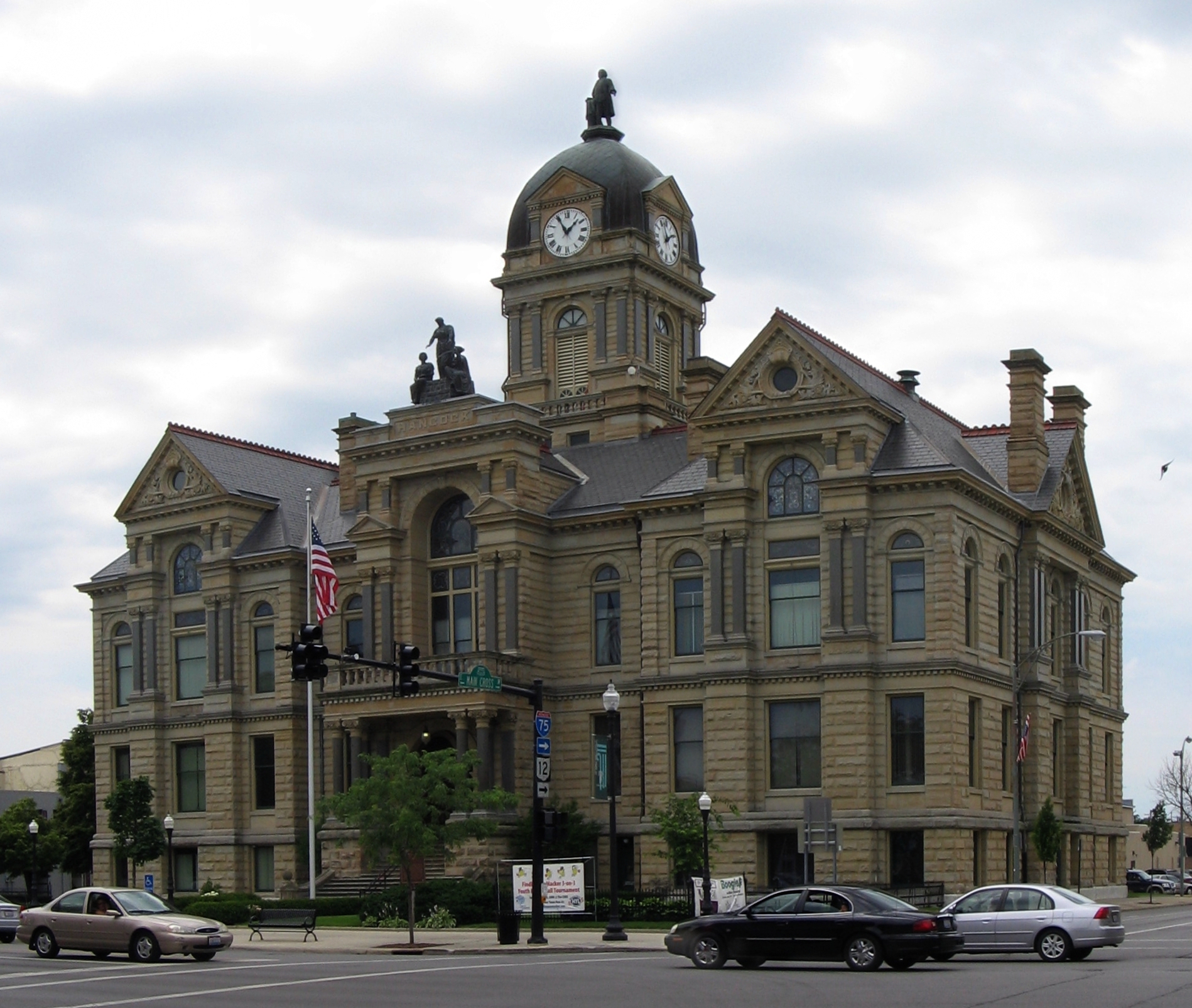
Verwaltung US-Bundesstaat: Ohio Verwaltungssitz: Findlay Adresse des
Verwaltungssitzes:County Courthouse
300 South Main Street
Findlay, OH 45840-3309Gründung: 12. Februar 1820 Gebildet aus: Logan County Vorwahl: 001 419 Demographie Einwohner: 73.503 (2005) Bevölkerungsdichte: 53,4 Einwohner/km² Geographie Fläche gesamt: 1.382 km² Wasserfläche: 6 km² Karte 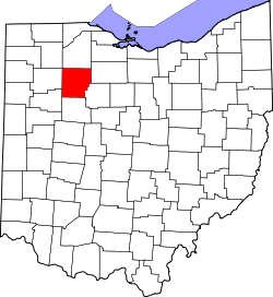
Website: www.co.hancock.oh.us Hancock County[2] ist ein County im Bundesstaat Ohio der Vereinigten Staaten von Amerika. Der Verwaltungssitz (County Seat) ist Findlay.
Inhaltsverzeichnis
Geografie
Das County liegt im mittleren Nordwesten von Ohio und hat eine Fläche von 1382 Quadratkilometern, wovon 6 Quadratkilometer Wasserfläche sind. Es grenzt im Uhrzeigersinn an folgende Countys: Wood County, Seneca County, Wyandot County, Hardin County, Allen County, Putnam County und Henry County.
Geschichte
Hancock County wurde am 12. Februar 1820 aus Teilen des Logan County gebildet. Benannt wurde es nach John Hancock, einem Führer des Aufstands gegen das britische Mutterland, der dritte Präsident des Kontinentalkongresses und erster Unterzeichner der Unabhängigkeitserklärung der Vereinigten Staaten.
Demografische Daten
Historische Einwohnerzahlen Census Einwohner ± in % 1830 813 — 1840 9986 1.000 % 1850 16.751 70 % 1860 22.886 40 % 1870 23.847 4 % 1880 27.784 20 % 1890 42.563 50 % 1900 41.993 -1 % 1910 37.860 -10 % 1920 38.394 1 % 1930 40.404 5 % 1940 40.793 1 % 1950 44.280 9 % 1960 53.686 20 % 1970 61.217 10 % 1980 64.581 5 % 1990 65.536 1 % 2000 71.295 9 % Vor 1900[3] 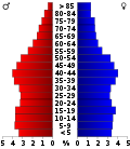 Alterspyramide des Hancock Countys (Stand: 2000)
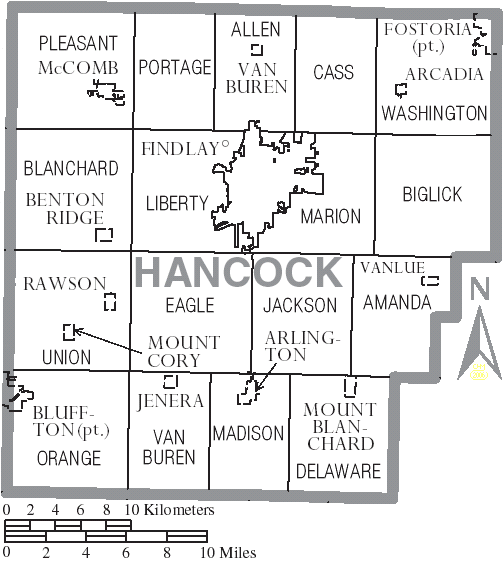
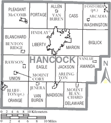 Karte des Hancock Countys
Nach der Volkszählung im Jahr 2000 lebten im Hancock County 71.295 Menschen in 27.898 Haushalten und 19.138 Familien. Die Bevölkerungsdichte betrug 52 Einwohner pro Quadratkilometer. Ethnisch betrachtet setzte sich die Bevölkerung zusammen aus 95,14 Prozent Weißen, 1,11 Prozent Afroamerikanern, 0,18 Prozent amerikanischen Ureinwohnern, 1,22 Prozent Asiaten, 0,02 Prozent Bewohnern aus dem pazifischen Inselraum und 1,22 Prozent aus anderen ethnischen Gruppen; 1,12 Prozent stammten von zwei oder mehr Ethnien ab. 3,07 Prozent der Bevölkerung waren spanischer oder lateinamerikanischer Abstammung.
Von den 27.898 Haushalten hatten 32,6 Prozent Kinder und Jugendliche unter 18 Jahre, die bei ihnen lebten. 56,4 Prozent waren verheiratete, zusammenlebende Paare, 8,7 Prozent waren allein erziehende Mütter, 31,4 Prozent waren keine Familien, 26,0 Prozent waren Singlehaushalte und in 9,8 Prozent lebten Menschen im Alter von 65 Jahren oder darüber. Die Durchschnittshaushaltsgröße betrug 2,49 und die durchschnittliche Familiengröße lag bei 3,01 Personen.
Auf das gesamte County bezogen setzte sich die Bevölkerung zusammen aus 25,7 Prozent Einwohnern unter 18 Jahren, 9,7 Prozent zwischen 18 und 24 Jahren, 28,7 Prozent zwischen 25 und 44 Jahren, 22,6 Prozent zwischen 45 und 64 Jahren und 13,2 Prozent waren 65 Jahre alt oder darüber. Das Durchschnittsalter betrug 36 Jahre. Auf 100 weibliche Personen kamen 94,3 männliche Personen. Auf 100 Frauen im Alter von 18 Jahren oder darüber kamen statistisch 91,2 Männer.
Das jährliche Durchschnittseinkommen eines Haushalts betrug 43.856 USD, das Durchschnittseinkommen der Familien betrug 51.490 USD. Männer hatten ein Durchschnittseinkommen von 37.139 USD, Frauen 24.374 USD. Das Prokopfeinkommen betrug 20.991 USD. 5,2 Prozent der Familien und 7,5 Prozent der Bevölkerung lebten unterhalb der Armutsgrenze. Davon waren 8,8 Prozent Kinder oder Jugendliche unter 18 Jahre und 6,1 Prozent waren Menschen über 65 Jahre. [6]
Einzelnachweise
- ↑ Auszug aus dem National Register of Historic Places. Abgerufen am 13. März 2011
- ↑ Hancock County im Geographic Names Information System des United States Geological Survey. Abgerufen am 22. Februar 2011
- ↑ U.S. Census Bureau _ Census of Population and Housing. Abgerufen am 17. Februar 2011
- ↑ Auszug aus Census.gov. Abgerufen am 21. Februar 2011
- ↑ Auszug aus factfinder.census.gov Abgerufen am 21. Februar 2011
- ↑ Hancock County, Ohio, Datenblatt mit den Ergebnissen der Volkszählung im Jahre 2000 bei factfinder.census.gov.

Liste der Countys in Ohio
Adams | Allen | Ashland | Ashtabula | Athens | Auglaize | Belmont | Brown | Butler | Carroll | Champaign | Clark | Clermont | Clinton | Columbiana | Coshocton | Crawford | Cuyahoga | Darke | Defiance | Delaware | Erie | Fairfield | Fayette | Franklin | Fulton | Gallia | Geauga | Greene | Guernsey | Hamilton | Hancock | Hardin | Harrison | Henry | Highland | Hocking | Holmes | Huron | Jackson | Jefferson | Knox | Lake | Lawrence | Licking | Logan | Lorain | Lucas | Madison | Mahoning | Marion | Medina | Meigs | Mercer | Miami | Monroe | Montgomery | Morgan | Morrow | Muskingum | Noble | Ottawa | Paulding | Perry | Pickaway | Pike | Portage | Preble | Putnam | Richland | Ross | Sandusky | Scioto | Seneca | Shelby | Stark | Summit | Trumbull | Tuscarawas | Union | Van Wert | Vinton | Warren | Washington | Wayne | Williams | Wood | Wyandot
Wikimedia Foundation.
Schlagen Sie auch in anderen Wörterbüchern nach:
Hancock County, Ohio — Infobox U.S. County county = Hancock County state = Ohio founded year = 1820cite web|url = http://www.odod.state.oh.us/research/FILES/S0/Hancock.pdf |title = Ohio County Profiles: Hancock County |accessdate = 2007 04 28 |publisher = Ohio… … Wikipedia
National Register of Historic Places listings in Hancock County, Ohio — Location of Hancock County in Ohio This is a list of the National Register of Historic Places listings in Hancock County, Ohio. This is intended to be a complete list of the properties and districts on the National Register of Historic Places in… … Wikipedia
Orange Township, Hancock County, Ohio — Township Farmland in northeastern Orange Township … Wikipedia
Marion Township, Hancock County, Ohio — Marion Township, Ohio Township Location of Marion Township in Hancock County … Wikipedia
Delaware Township, Hancock County, Ohio — Delaware Township, Ohio Township Location of Delaware Township in Hancock County … Wikipedia
Allen Township, Hancock County, Ohio — Infobox Settlement official name = Allen Township, Ohio settlement type = Township nickname = motto = imagesize = image caption = image mapsize = 250x200px map caption = Location of Allen Township in Hancock County. mapsize1 = map caption1 =… … Wikipedia
Pleasant Township, Hancock County, Ohio — Infobox Settlement official name = Pleasant Township, Ohio settlement type = Township nickname = motto = imagesize = image caption = image mapsize = 250x200px map caption = Location of Pleasant Township in Hancock County. mapsize1 = map caption1 … Wikipedia
Washington Township, Hancock County, Ohio — Infobox Settlement official name = Washington Township, Ohio settlement type = Township nickname = motto = imagesize = image caption = image mapsize = 250x200px map caption = Location of Washington Township in Hancock County. mapsize1 = map… … Wikipedia
Liberty Township, Hancock County, Ohio — Infobox Settlement official name = Liberty Township, Ohio settlement type = Township nickname = motto = imagesize = image caption = image mapsize = 250x200px map caption = Location of Liberty Township in Hancock County. mapsize1 = map caption1 =… … Wikipedia
Blanchard Township, Hancock County, Ohio — Infobox Settlement official name = Blanchard Township, Ohio settlement type = Township nickname = motto = imagesize = image caption = image mapsize = 250x200px map caption = Location of Blanchard Township in Hancock County. mapsize1 = map… … Wikipedia
Hancock County (Ohio)


18+
© Academic, 2000-2026
- Kontaktieren Sie uns: Unterstützung, Werbung
Wörterbücher Export, schritte mit PHP, Joomla, Drupal, WordPress, MODx.