- Païta
-
Basisdaten Land: Neukaledonien Provinz: Province Sud Höhe: 0 m - 1618 m Fläche: 699,7 km² Einwohner: 12.062
(2004)Bevölkerungs- dichte: 17 Einwohner je km² INSEE-Code: 98821[1] Postleitzahl: 98890[2] Karte Païta ist eine Gemeinde in der Südprovinz in Neukaledonien.
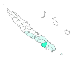
Die Gemeinde liegt größtenteils auf der Hauptinsel Grande Terre, aber auch weitere kleine Inseln vor der Küste gehören dazu. Païta liegt in der Nachbarschaft zu Nouméa und gehört somit in Teilen zum Großraum Nouméa. Die Orte in der Gemeinde Païta sind: Bangou(?), Col de la pirogue, Katiranoma, Kokoréta(?), Makou(?), Naniouni(?), N'dé, Onghoué(?), Païta (Hauptort), Plaine aux cailloux, Port Laguerre(?), Sanatorium (Païta)(?), Saint-Laurent (Païta), Tamoa, Timbia, Tongouin und Tontouta(?).
Die höchste Erhebung ist der Mont Humboldt mit 1.618 m.
Auf dem Gebiet der Gemeinde Païta befindet sich auch der Flughafen La Tontouta.
Bevölkerung
Bevölkerungsentwicklung in Païta (2009 geschätzt)[3] Einwohner 1.397 1.903 2.522 3.407 4.834 6.049 7.862 12.062 15.206 Jahr 1956 1963 1969 1976 1983 1989 1996 2004 2009 Weblinks
Commons: Païta – Sammlung von Bildern, Videos und AudiodateienEinzelnachweise
- ↑ Mairie de Païta
- ↑ Les codes postaux, Nouvelle-Calédonie
- ↑ Bevölkerungsentwicklung in Païta 1956–2009
Gemeinden in NeukaledonienBelep | Bouloupari | Bourail | Canala | Dumbéa | Farino | Hienghène | Houaïlou | L’Île-des-Pins | Kaala-Gomen | Koné | Kouaoua | Koumac | La Foa | Lifou | Maré | Moindou | Le Mont-Dore | Nouméa | Ouégoa | Ouvéa | Païta | Poindimié | Ponérihouen | Pouébo | Pouembout | Poum | Poya | Sarraméa | Thio | Touho | Voh | Yaté
Wikimedia Foundation.
Schlagen Sie auch in anderen Wörterbüchern nach:
Paita — Saltar a navegación, búsqueda Paita Bandera … Wikipedia Español
Paita — Héraldique … Wikipédia en Français
Paita — (früher: San Francisco de la Buena Esperanza) ist ebenso der Name der Hauptstadt dieser Provinz, einer Hafenstadt 640 km nordwestlich der Landeshauptstadt Lima und 90 km nordwestlich der Hauptstadt der Region, Piura. Inhaltsverzeichnis 1 Lage 2… … Deutsch Wikipedia
paita — paità sf. (4) užgaidas, noras: Kas tai būtų, kad aš visas vaikų paitàs pildytau! Sn … Dictionary of the Lithuanian Language
Paita — Paita, Stadt in Peru, s. Payta … Kleines Konversations-Lexikon
paită — páită, páite, s.f. (reg.) 1. covată de frământat pâinea. 2. scândură pe care se taie aluatul în bucăţi. Trimis de blaurb, 01.09.2008. Sursa: DAR … Dicționar Român
Païta — 22° 08′ 01″ S 166° 21′ 02″ E / 22.133711, 166.350494 … Wikipédia en Français
Paita — For the town in New Caledonia, see Païta. Paita (or: Payta) is a city in northwestern Peru. It is the capital of the Paita Province which is in the Piura Region. It is a leading seaport in that region. It is located 1,089 km northwest of the… … Wikipedia
Paita — 1 Original name in latin Pata Name in other language Paita, Pata State code NC Continent/City Pacific/Noumea longitude 22.13333 latitude 166.36667 altitude 18 Population 12617 Date 2012 02 02 2 Original name in latin Paita Name in other language… … Cities with a population over 1000 database
Païta — French commune |nomcommune=Païta province=South Province map size=300px adjustable mapcaption=Location of the commune (in red) within New Caledonia insee=98821 cp=98890 maire=Harold Martin |mandat= lat long= |longitude=166.37|latitude= 22.13 alt… … Wikipedia