- Santa Fé de Goiás
-
Santa Fé de Goiás Wappen Flagge 

Karten 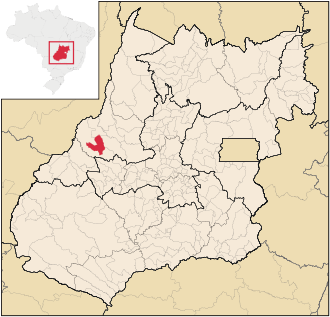 Gemeindegebiet von Santa Fé de Goías im Bundesstaat Goiás / Brasilien

Santa Fé de Goiás Lage der Ortschaft Santa Fé de Goiás in GoiásBasisdaten Staat:  Brasilien (BRA)
Verwaltungsgliederung: Mittelwesten Bundesstaat:  Goiás (GO)
Mesoregion: Nordwest-Goiás Mikroregion: Río Vermelho Distanz zu Goiânia: 259 km [1] Geografische Lage: 15° 46′ S, 51° 6′ W-15.768888888889-51.105833333333362Koordinaten: 15° 46′ S, 51° 6′ W Zeitzone: UTC-3
Sommer: UTC-2Höhe: 362 m ü. NN Fläche: 1.160,8 km² Einwohner: 4.768 [2] Bevölkerungsdichte: 4.1 Einwohner / km² Telefonvorwahl: +5562 Postleitzahl (CEP): 76265-000 Adresse der Stadtverwaltung: Offizielle Website: Jahrestag: 1. Juni Gemeindegründung: 1989 Politik Bürgermeister: Gilmar Batista Teixeira (PP), (2009–2012) Santa Fé de Goiás ist eine kleine brasilianische, politische Gemeinde im Bundesstaat Goiás in der Mesoregion Nordwest-Goiás und in der Mikroregion Rio Vermelho. Sie liegt westlich der brasilianischen Hauptstadt Brasília und nordwestlich der Hauptstadt Goiânia.
Wirtschaftlich bedeutsam sind in Santa Fé de Goiás vorwiegend Viehzucht, Landwirtschaft und Milcherzeugung.Geographie
Von Osten über Süden bis Westen grenzt Santa Fé de Goiás an die Gemeinde Jussara. Im Nordwesten und Norden liegt Britânia und im Nordosten Itapirapuã.
Einzelnachweise
- ↑ SEPLAN: Straßenkilometer nach Goiânia
- ↑ Ergebnisse der Volkszählung von 2010 in Goiás, durchgeführt vom IBGE.
Gemeinden im Bundesstaat GoiásAbadia de Goiás | Abadiânia | Acreúna | Adelândia | Água Fria de Goiás | Água Limpa | Águas Lindas de Goiás | Alexânia | Aloândia | Alto Horizonte | Alto Paraíso de Goiás | Alvorada do Norte | Amaralina | Americano do Brasil | Amorinópolis | Anápolis | Anhanguera | Anicuns | Aparecida de Goiânia | Aparecida do Rio Doce | Aporé | Araçu | Aragarças | Aragoiânia | Araguapaz | Arenópolis | Aruanã | Aurilândia | Avelinópolis | Baliza | Barro Alto | Bela Vista de Goiás | Bom Jardim de Goiás | Bom Jesus de Goiás | Bonfinópolis | Bonópolis | Brazabrantes | Britânia | Buriti Alegre | Buriti de Goiás | Buritinópolis | Cabeceiras | Cachoeira Alta | Cachoeira de Goiás | Cachoeira Dourada | Caçu | Caiapônia | Caldas Novas | Caldazinha | Campestre de Goiás | Campinaçu | Campinorte | Campo Alegre de Goiás | Campo Limpo de Goiás | Campos Belos | Campos Verdes | Carmo do Rio Verde | Castelândia | Catalão | Caturaí | Cavalcante | Ceres | Cezarina | Chapadão do Céu | Cidade Ocidental | Cocalzinho de Goiás | Colinas do Sul | Córrego do Ouro | Corumbá de Goiás | Corumbaíba | Cristalina | Cristianópolis | Crixás | Cromínia | Cumari | Damianópolis | Damolândia | Davinópolis | Diorama | Divinópolis de Goiás | Doverlândia | Edealina | Edéia | Estrela do Norte | Faina | Fazenda Nova | Firminópolis | Flores de Goiás | Formosa | Gameleira de Goiás | Goianápolis | Goiandira | Goianésia | Goiânia | Goianira | Goiás Velho | Goiatuba | Gouvelândia | Guapó | Guaraíta | Guarani de Goiás | Guarinos | Heitoraí | Hidrolândia | Hidrolina | Iaciara | Inaciolândia | Indiara | Inhumas | Ipameri | Ipiranga de Goiás | Iporá | Israelândia | Itaberaí | Itaguari | Itaguaru | Itajá | Itapaci | Itapirapuã | Itapuranga | Itarumã | Itauçu | Itumbiara | Ivolândia | Jandaia | Jaraguá | Jataí | Jaupaci | Jesúpolis | Joviânia | Jussara | Lagoa Santa | Leopoldo de Bulhões | Luziânia | Mairipotaba | Mambaí | Mara Rosa | Marzagão | Matrinchã | Maurilândia | Mimoso de Goiás | Minaçu | Mineiros | Moiporá | Monte Alegre de Goiás | Montes Claros de Goiás | Montividiu | Montividiu do Norte | Morrinhos | Morro Agudo de Goiás | Mossâmedes | Mozarlândia | Mundo Novo | Mutunópolis | Nazário | Nerópolis | Niquelândia | Nova América | Nova Aurora | Nova Crixás | Nova Glória | Nova Iguaçu de Goiás | Nova Roma | Nova Veneza | Novo Brasil | Novo Gama | Novo Planalto | Orizona | Ouro Verde de Goiás | Ouvidor | Padre Bernardo | Palestina de Goiás | Palmeiras de Goiás | Palmelo | Palminópolis | Panamá | Paranaiguara | Paraúna | Perolândia | Petrolina de Goiás | Pilar de Goiás | Piracanjuba | Piranhas | Pirenópolis | Pires do Rio | Planaltina | Pontalina | Porangatu | Porteirão | Portelândia | Posse | Professor Jamil | Quirinópolis | Rialma | Rianápolis | Rio Quente | Rio Verde | Rubiataba | Sanclerlândia | Santa Bárbara de Goiás | Santa Cruz de Goiás | Santa Fé de Goiás | Santa Helena de Goiás | Santa Isabel | Santa Rita do Araguaia | Santa Rita do Novo Destino | Santa Rosa de Goiás | Santa Tereza de Goiás | Santa Terezinha de Goiás | Santo Antônio da Barra | Santo Antônio de Goiás | Santo Antônio do Descoberto | São Domingos | São Francisco de Goiás | São João d’Aliança | São João da Paraúna | São Luís de Montes Belos | São Luíz do Norte | São Miguel do Araguaia | São Miguel do Passa Quatro | São Patrício | São Simão | Senador Canedo | Serranópolis | Silvânia | Simolândia | Sítio d'Abadia | Taquaral de Goiás | Teresina de Goiás | Terezópolis de Goiás | Três Ranchos | Trindade | Trombas | Turvânia | Turvelândia | Uirapuru | Uruaçu | Uruana | Urutaí | Valparaíso de Goiás | Varjão | Vianópolis | Vicentinópolis | Vila Boa | Vila Propício
Wikimedia Foundation.
Schlagen Sie auch in anderen Wörterbüchern nach:
Santa Cruz de Goiás — Wappen Flagge … Deutsch Wikipedia
Santa Rosa de Goiás — Wappen Flagge … Deutsch Wikipedia
Santa Bárbara de Goiás — Wappen Flagge … Deutsch Wikipedia
Santa Helena de Goiás — is a small city and municipality in southwestern Goiás state, Brazil. It is a large producer of corn, sugarcane, soybeans, and poultry.LocationSanta Helena is located in the Sudoeste de Goiás Microregion, 31 kilometers east of the important city… … Wikipedia
Santa Terezinha de Goiás — is a small city and municipality in north Goiás state, Brazil. Santa Terezinha is sometimes written as Santa Teresinha .LocationSanta Terezinha is in the extreme north of the state, 174 km. southwest of Porangatu. It is 66 km. west of the… … Wikipedia
Santa Tereza de Goiás — Santa Tereza de Goias is a small town and municipality in north Goiás state, Brazil. Santa Tereza de Goiás is often spelled Santa Teresa de Goiás .LocationSanta Tereza is located in the extreme north of the state 35 km. south of Porangatu. It is… … Wikipedia
Santa Cruz de Goiás — is a small town and municipality in southeast Goiás state, Brazil. GeographySanta Cruz is located in the southeastern part of the state, 33 km. west of regional center, Pires do Rio. The Rio dos Bois, a tributary of the Corumbá River flows from… … Wikipedia
Santa Rosa de Goiás — is a small town and municipality in central Goiás state, Brazil.LocationSanta Rosa is located 78 km. northwest of the regional center, Anápolis. It is approximately half the distance between Taquaral de Goiás and Petrolina de Goiás. Highway… … Wikipedia
Santa Bárbara de Goiás — is a small town and municipality in eastern Goiás state, Brazil.LocationSanta Bárbara is located due west of Goiânia. Nearby towns are Trindade (40 km. to the east), and Nazário (17 km. to the west] . The regional center, Anicuns) is 25 km. to… … Wikipedia
Santa Fé de Goiás — is a small town and municipality in west central Goiás state, Brazil.LocationSanta Fé is located almost directly west of Brasília and northwest of Goiânia. The nearest town of any size is Jussara, which lies 34 km. to the southeast. *Distance to… … Wikipedia
Santa Fé de Goiás


18+
© Academic, 2000-2026
- Kontaktieren Sie uns: Unterstützung, Werbung
Wörterbücher Export, schritte mit PHP, Joomla, Drupal, WordPress, MODx.