- Petrolina de Goiás
-
Petrolina de Goiás Wappen Flagge 

Karte 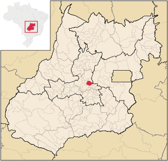 Lage des Gemeindegebietes von Petrolina de Goiás im Bundesstaat Goiás / Brasilien
Basisdaten Staat:  Brasilien (BRA)
Verwaltungsgliederung: Mittelwesten Bundesstaat:  Goiás (GO)
Mesoregion: Zentral-Goiás Mikroregion: Anápolis Angrenzende Gemeinden: Jesúpolis, São Francisco de Goiás, Pirenópolis, Anápolis, Ouro Verde de Goiás, Damolândia, Inhumas, Itauçu, Santa Rosa de Goiás Distanz zu Goiânia: 80 km [1] Geografische Lage: 16° 6′ S, 49° 20′ W-16.095-49.337777777778720Koordinaten: 16° 6′ S, 49° 20′ W Zeitzone: UTC-3
Sommer: UTC-2Höhe: 720 m ü. NN Fläche: 540,451 km² Einwohner: 10.285 [2] Bevölkerungsdichte: 19,0 Einwohner / km² Telefonvorwahl: +55 62 Postleitzahl (CEP): 75480-000 Adresse der Stadtverwaltung: Praça Teófilo Vieira Motta, 101
Setor Centro [3]Offizielle Website: Jahrestag: 25. Juni Gemeindegründung: 1958[4] Politik [3] Bürgermeister: Danozete Gonçalves Ferreira (PMDB), 2009–2012 Vize-Bürgermeister: Petrolina de Goiás ist eine brasilianische politische Gemeinde im Bundesstaat Goiás.
Sie liegt westlich der brasilianischen Hauptstadt Brasília und nördlich der Hauptstadt Goiânia in der Mesoregion Zentral-Goiás und in der Mikroregion Anápolis. Petrolina de Goiás ist 80 km entfernt von der Hauptstadt.
Geographische Lage
Petrolina de Goiás grenzt an die Gemeinden[5]:
- im Norden an Jesúpolis und São Francisco de Goiás
- im Osten an Pirenópolis und Anápolis
- im Südosten an Ouro Verde de Goiás
- im Süden an Damolândia
- im Südwesten an Inhumas und Itauçu
- im Westen Santa Rosa de Goiás
Siehe auch
Einzelnachweise
- ↑ Distanzen der Gemeinden in Goiás zu Goiânia
- ↑ Erste Ergebnisse der Volkszählung von 2010 in Goiás, durchgeführt vom IBGE.
- ↑ a b FGM: Federação Goiana de Municípios, Dados Políticos, (port.)
- ↑ IBGE: Geschichte von Petrolina de Goiás (port.)
- ↑ Politische Karte "GO_Politico.pdf" von Goiás ftp-Server des IBGE (4.8 MB)
Gemeinden im Bundesstaat GoiásAbadia de Goiás | Abadiânia | Acreúna | Adelândia | Água Fria de Goiás | Água Limpa | Águas Lindas de Goiás | Alexânia | Aloândia | Alto Horizonte | Alto Paraíso de Goiás | Alvorada do Norte | Amaralina | Americano do Brasil | Amorinópolis | Anápolis | Anhanguera | Anicuns | Aparecida de Goiânia | Aparecida do Rio Doce | Aporé | Araçu | Aragarças | Aragoiânia | Araguapaz | Arenópolis | Aruanã | Aurilândia | Avelinópolis | Baliza | Barro Alto | Bela Vista de Goiás | Bom Jardim de Goiás | Bom Jesus de Goiás | Bonfinópolis | Bonópolis | Brazabrantes | Britânia | Buriti Alegre | Buriti de Goiás | Buritinópolis | Cabeceiras | Cachoeira Alta | Cachoeira de Goiás | Cachoeira Dourada | Caçu | Caiapônia | Caldas Novas | Caldazinha | Campestre de Goiás | Campinaçu | Campinorte | Campo Alegre de Goiás | Campo Limpo de Goiás | Campos Belos | Campos Verdes | Carmo do Rio Verde | Castelândia | Catalão | Caturaí | Cavalcante | Ceres | Cezarina | Chapadão do Céu | Cidade Ocidental | Cocalzinho de Goiás | Colinas do Sul | Córrego do Ouro | Corumbá de Goiás | Corumbaíba | Cristalina | Cristianópolis | Crixás | Cromínia | Cumari | Damianópolis | Damolândia | Davinópolis | Diorama | Divinópolis de Goiás | Doverlândia | Edealina | Edéia | Estrela do Norte | Faina | Fazenda Nova | Firminópolis | Flores de Goiás | Formosa | Gameleira de Goiás | Goianápolis | Goiandira | Goianésia | Goiânia | Goianira | Goiás Velho | Goiatuba | Gouvelândia | Guapó | Guaraíta | Guarani de Goiás | Guarinos | Heitoraí | Hidrolândia | Hidrolina | Iaciara | Inaciolândia | Indiara | Inhumas | Ipameri | Ipiranga de Goiás | Iporá | Israelândia | Itaberaí | Itaguari | Itaguaru | Itajá | Itapaci | Itapirapuã | Itapuranga | Itarumã | Itauçu | Itumbiara | Ivolândia | Jandaia | Jaraguá | Jataí | Jaupaci | Jesúpolis | Joviânia | Jussara | Lagoa Santa | Leopoldo de Bulhões | Luziânia | Mairipotaba | Mambaí | Mara Rosa | Marzagão | Matrinchã | Maurilândia | Mimoso de Goiás | Minaçu | Mineiros | Moiporá | Monte Alegre de Goiás | Montes Claros de Goiás | Montividiu | Montividiu do Norte | Morrinhos | Morro Agudo de Goiás | Mossâmedes | Mozarlândia | Mundo Novo | Mutunópolis | Nazário | Nerópolis | Niquelândia | Nova América | Nova Aurora | Nova Crixás | Nova Glória | Nova Iguaçu de Goiás | Nova Roma | Nova Veneza | Novo Brasil | Novo Gama | Novo Planalto | Orizona | Ouro Verde de Goiás | Ouvidor | Padre Bernardo | Palestina de Goiás | Palmeiras de Goiás | Palmelo | Palminópolis | Panamá | Paranaiguara | Paraúna | Perolândia | Petrolina de Goiás | Pilar de Goiás | Piracanjuba | Piranhas | Pirenópolis | Pires do Rio | Planaltina | Pontalina | Porangatu | Porteirão | Portelândia | Posse | Professor Jamil | Quirinópolis | Rialma | Rianápolis | Rio Quente | Rio Verde | Rubiataba | Sanclerlândia | Santa Bárbara de Goiás | Santa Cruz de Goiás | Santa Fé de Goiás | Santa Helena de Goiás | Santa Isabel | Santa Rita do Araguaia | Santa Rita do Novo Destino | Santa Rosa de Goiás | Santa Tereza de Goiás | Santa Terezinha de Goiás | Santo Antônio da Barra | Santo Antônio de Goiás | Santo Antônio do Descoberto | São Domingos | São Francisco de Goiás | São João d’Aliança | São João da Paraúna | São Luís de Montes Belos | São Luíz do Norte | São Miguel do Araguaia | São Miguel do Passa Quatro | São Patrício | São Simão | Senador Canedo | Serranópolis | Silvânia | Simolândia | Sítio d'Abadia | Taquaral de Goiás | Teresina de Goiás | Terezópolis de Goiás | Três Ranchos | Trindade | Trombas | Turvânia | Turvelândia | Uirapuru | Uruaçu | Uruana | Urutaí | Valparaíso de Goiás | Varjão | Vianópolis | Vicentinópolis | Vila Boa | Vila Propício
Wikimedia Foundation.
Schlagen Sie auch in anderen Wörterbüchern nach:
Petrolina de Goiás — is a small town and municipality in central Goiás state, Brazil.LocationPetrolina de Goiás is located 81 km. almost due north of Goiânia, the state capital. It is 23 km. southwest of São Francisco de Goiás, 23 km. northwest of Ouro Verde de Goiás … Wikipedia
Petrolina De Goias — Admin ASC 2 Code Orig. name Petrolina de Goiás Country and Admin Code BR.29.5216809 BR … World countries Adminstrative division ASC I-II
Petrolina de Goias — Original name in latin Petrolina de Gois Name in other language Goialina, Petrolina State code BR Continent/City America/Sao Paulo longitude 16.095 latitude 49.33806 altitude 720 Population 7710 Date 2012 08 03 … Cities with a population over 1000 database
Damolândia (Goiás) — Damolândia Wappen Flagge … Deutsch Wikipedia
Inhumas (Goiás) — Wappen Flagge … Deutsch Wikipedia
Jesúpolis (Goiás) — Jesúpolis Wappen Flagge … Deutsch Wikipedia
Ouro Verde de Goiás — Wappen Flagge … Deutsch Wikipedia
Santa Rosa de Goiás — Wappen Flagge … Deutsch Wikipedia
São Francisco de Goiás — Wappen Flagge … Deutsch Wikipedia
Itauçu (Goiás) — Wappen Flagge … Deutsch Wikipedia
Petrolina de Goiás


18+
© Academic, 2000-2025
- Kontaktieren Sie uns: Unterstützung, Werbung
Wörterbücher Export, schritte mit PHP, Joomla, Drupal, WordPress, MODx.