- Martin County (North Carolina)
-
Verwaltung US-Bundesstaat: North Carolina Verwaltungssitz: Williamston Adresse des
Verwaltungssitzes:County Courthouse
P.O. Box 668
Williamston, NC 27892-0668Gründung: 1774 Gebildet aus: Halifax County
Tyrrell CountyVorwahl: 001 252 Demographie Einwohner: 25.593 (2000) Bevölkerungsdichte: 21,4 Einwohner/km² Geographie Fläche gesamt: 1.195 km² Wasserfläche: 1 km² Karte 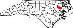
Website: www.martincountyncgov.com Martin County[1] ist ein County im Bundesstaat North Carolina der Vereinigten Staaten von Amerika. Der Verwaltungssitz (County Seat) ist Williamston, das nach William Williams benannt wurde, einem Colonel im Amerikanischen Unabhängigkeitskrieg.
Inhaltsverzeichnis
Geografie
Das County liegt im mittleren Osten von North Carolina, ist im Norden etwa 80 km von Virginia entfernt und hat eine Fläche von 1195 Quadratkilometern, wovon 1 Quadratkilometer Wasserfläche sind. Es grenzt im Uhrzeigersinn an folgende Countys: Bertie County, Washington County, Beaufort County, Pitt County, Edgecombe County und Halifax County.
Martin County ist in 10 Townships aufgeteilt: Bear Grass, Cross Roads, Goose Nest, Griffins, Hamilton, Jamesville, Poplar Point, Robersonville, Williams und Williamston.
Geschichte
Martin County wurde 1774 aus Teilen des Halifax County und des Tyrrell County gebildet. Benannt wurde es nach Josiah Martin, dem letzten britischen königlichen Gouverneur von North Carolina.
Demografische Daten
Historische Einwohnerzahlen Census Einwohner ± in % 1790 6080 — 1800 5629 -7 % 1810 5987 6 % 1820 6320 6 % 1830 8539 40 % 1840 7637 -10 % 1850 8307 9 % 1860 10.195 20 % 1870 9647 -5 % 1880 13.140 40 % 1890 15.221 20 % 1900 15.383 1 % 1910 17.797 20 % 1920 20.828 20 % 1930 23.400 10 % 1940 26.111 10 % 1950 27.938 7 % 1960 27.139 -3 % 1970 24.730 -9 % 1980 25.948 5 % 1990 25.078 -3 % 2000 25.593 2 % Vor 1900[2] Nach der Volkszählung im Jahr 2000 lebten im Martin County 25.593 Menschen in 10.020 Haushalten und 7.194 Familien. Die Bevölkerungsdichte beträgt 21 Einwohner pro Quadratkilometer. Ethnisch betrachtet setzt sich die Bevölkerung zusammen aus 52,54 Prozent Weißen, 45,37 Prozent Afroamerikanern, 0,29 Prozent amerikanischen Ureinwohnern, 0,24 Prozent Asiaten, 0,03 Prozent Bewohnern aus dem pazifischen Inselraum und 0,90 Prozent aus anderen ethnischen Gruppen; 0,63 Prozent stammten von zwei oder mehr Ethnien ab. 2,06 Prozent der Bevölkerung waren spanischer oder lateinamerikanischer Abstammung.
Von den 10.020 Haushalten hatten 31,6 Prozent Kinder unter 18 Jahren, die bei ihnen lebten. 50,3 Prozent davon waren verheiratete, zusammenlebende Paare, 17,6 Prozent waren allein erziehende Mütter und 28,2 Prozent waren keine Familien. 25,7 Prozent waren Singlehaushalte und in 11,9 Prozent lebten Menschen mit 65 Jahren oder älter. Die Durchschnittshaushaltsgröße betrug 2,53 und die durchschnittliche Familiengröße war 3,02 Personen.
25,5 Prozent der Bevölkerung waren unter 18 Jahre alt. 7,5 Prozent zwischen 18 und 24 Jahre, 26,8 Prozent zwischen 25 und 44 Jahre, 25,0 Prozent zwischen 45 und 64, und 15,2 Prozent waren 65 Jahre alt oder Älter. Das Durchschnittsalter betrug 39 Jahre. Auf alle weibliche Personen kamen 86,5 männliche Personen. Auf alle Frauen im Alter von 18 Jahren oder darüber kamen 81,8 Männer.
Das jährliche Durchschnittseinkommen eines Haushalts betrug 28.793 $ und das jährliche Durchschnittseinkommen einer Familie betrug 35.428 $. Männer hatten ein durchschnittliches Einkommen von 29.818 $ gegenüber den Frauen mit 19.167 $. Das Prokopfeinkommen betrug 15.102 $. 20,2 Prozent der Bevölkerung und 16,3 Prozent der Familien lebten unterhalb der Armutsgrenze. 27,5 Prozent von ihnen sind Kinder und Jugendliche unter 18 Jahre und 25,7 Prozent sind 65 Jahre oder älter. [5]
Siehe auch
Einzelnachweise
- ↑ GNIS-ID: 1026328. Abgerufen am 22. Februar 2011 (englisch).
- ↑ U.S. Census Bureau - Census of Population and Housing. Abgerufen am 15. März 2011
- ↑ Auszug aus Census.gov. Abgerufen am 20. Februar 2011
- ↑ Auszug aus factfinder.census.gov Abgerufen am 20. Februar 2011
- ↑ Martin County, North Carolina, Datenblatt mit den Ergebnissen der Volkszählung im Jahre 2000 bei factfinder.census.gov.

Liste der Countys in North Carolina
Alamance | Alexander | Alleghany | Anson | Ashe | Avery | Beaufort | Bertie | Bladen | Brunswick | Buncombe | Burke | Cabarrus | Caldwell | Camden | Carteret | Caswell | Catawba | Chatham | Cherokee | Chowan | Clay | Cleveland | Columbus | Craven | Cumberland | Currituck | Dare | Davidson | Davie | Duplin | Durham | Edgecombe | Forsyth | Franklin | Gaston | Gates | Graham | Granville | Greene | Guilford | Halifax | Harnett | Haywood | Henderson | Hertford | Hoke | Hyde | Iredell | Jackson | Johnston | Jones | Lee | Lenoir | Lincoln | Macon | Madison | Martin | McDowell | Mecklenburg | Mitchell | Montgomery | Moore | Nash | New Hanover | Northampton | Onslow | Orange | Pamlico | Pasquotank | Pender | Perquimans | Person | Pitt | Polk | Randolph | Richmond | Robeson | Rockingham | Rowan | Rutherford | Sampson | Scotland | Stanly | Stokes | Surry | Swain | Transylvania | Tyrrell | Union | Vance | Wake | Warren | Washington | Watauga | Wayne | Wilkes | Wilson | Yadkin | Yancey
Wikimedia Foundation.
Schlagen Sie auch in anderen Wörterbüchern nach:
Martin County, North Carolina — This article is about Martin County, North Carolina. See Martin County for uses in other states. Martin County, North Carolina Location in the state of North Carolina … Wikipedia
National Register of Historic Places listings in Martin County, North Carolina — Map of all coordinates from Google Map of all coordinates from Bing … Wikipedia
Halifax County, North Carolina — Infobox U.S. County county = Halifax County state = North Carolina map size = 250 founded = 1758 seat = Halifax | area total sq mi =731 area water sq mi =6 area percentage = 0.82% census yr = 2000 pop = 57370 density km2 =31 web =… … Wikipedia
Pitt County, North Carolina — Infobox U.S. County county = Pitt County state = North Carolina map size = 250 founded = 1760 seat = Greenville | area total sq mi =655 area land sq mi =652 area water sq mi =3 area percentage = 0.49% census yr = 2000 pop = 133798 density km2 =79 … Wikipedia
Bertie County, North Carolina — Infobox U.S. County county = Bertie County state = North Carolina map size = 250 founded = 1722 seat = Windsor | area total sq mi =741 area water sq mi =42 area percentage = 5.67% census yr = 2000 pop = 19773 density km2 =21 web =… … Wikipedia
Washington County, North Carolina — Infobox U.S. County county = Washington County state = North Carolina map size = 250 founded = 1799 seat = Plymouth | area total sq mi =424 area water sq mi =76 area percentage = 17.89% census yr = 2000 pop = 13723 density sq mi =39 web =… … Wikipedia
Edgecombe County, North Carolina — Infobox U.S. County county = Edgecombe County state = North Carolina map size = 250 founded = 1741 seat = Tarboro | area total sq mi =507 area water sq mi =2 area percentage = 0.31% census yr = 2000 pop = 55606 density km2 =43 web = |Edgecombe… … Wikipedia
Wilkes County, North Carolina — Seal … Wikipedia
Wake County, North Carolina — Infobox U.S. County county = Wake County state = North Carolina map size = 250 founded = 1771 seat = Raleigh | area total sq mi =857 area land sq mi =832 area water sq mi =25 area percentage = 2.95% census estimate yr = 2007 pop = 832970 density… … Wikipedia
Orange County, North Carolina — For other uses, see Orange County (disambiguation). Orange County, North Carolina Seal … Wikipedia
Martin County (North Carolina)

18+
© Academic, 2000-2026
- Kontaktieren Sie uns: Unterstützung, Werbung
Wörterbücher Export, schritte mit PHP, Joomla, Drupal, WordPress, MODx.