- Rowan County (North Carolina)
-
Verwaltung US-Bundesstaat: North Carolina Verwaltungssitz: Salisbury Adresse des
Verwaltungssitzes:County Administration Building
130 West Innes Street
Salisbury, NC 28144-4365Gründung: 27. März 1753 Gebildet aus: Anson County Vorwahl: 001 704 Demographie Einwohner: 130.340 (2000) Bevölkerungsdichte: 98,4 Einwohner/km² Geographie Fläche gesamt: 1.357 km² Wasserfläche: 32 km² Karte 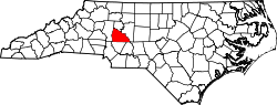
Website: www.co.rowan.nc.us Rowan County[1] ist ein County im Bundesstaat North Carolina der Vereinigten Staaten von Amerika. Der Verwaltungssitz (County Seat) ist Salisbury.
Inhaltsverzeichnis
Geografie
Das County liegt im mittleren Westen von North Carolina, ist im Südwesten etwa 60 km von South Carolina entfernt und hat eine Fläche von 1357 Quadratkilometern, wovon 32 Quadratkilometer Wasserfläche sind. Es grenzt im Uhrzeigersinn an folgende Countys: Davie County, Davidson County, Stanly County, Cabarrus County und Iredell County.
Rowan County ist in 16 Townships aufgeteilt: Atwell, China Grove, Cleveland, East Spencer, Franklin, Gold Hill, Kannapolis, Litaker, Locke, Morgan, Mount Ulla, Providence, Salisbury, Scotch Irish, Spencer, Steele und Unity.
Geschichte
Rowan County wurde am 27. März 1753 aus Teilen des Anson County gebildet. Benannt wurde es nach Matthew Rowan, einem politischen Führer und Gouverneur von North Carolina von 1753 bis 1754.
Demografische Daten
Historische Einwohnerzahlen Census Einwohner ± in % 1790 15.828 — 1800 20.060 30 % 1810 21.543 7 % 1820 26.009 20 % 1830 20.786 -20 % 1840 12.109 -40 % 1850 13.870 10 % 1860 14.589 5 % 1870 16.810 20 % 1880 19.965 20 % 1890 24.123 20 % 1900 31.066 30 % 1910 37.521 20 % 1920 44.062 20 % 1930 56.665 30 % 1940 69.206 20 % 1950 75.410 9 % 1960 82.817 10 % 1970 90.035 9 % 1980 99.186 10 % 1990 110.605 10 % 2000 130.340 20 % Vor 1900[2] Nach der Volkszählung im Jahr 2000 lebten im Rowan County 130.340 Menschen in 49.940 Haushalten und 35.507 Familien. Die Bevölkerungsdichte beträgt 98 Einwohner pro Quadratkilometer. Ethnisch betrachtet setzt sich die Bevölkerung zusammen aus 80,02 Prozent Weißen, 15,78 Prozent Afroamerikanern, 0,33 Prozent amerikanischen Ureinwohnern, 0,85 Prozent Asiaten, 0,03 Prozent Bewohnern aus dem pazifischen Inselraum und 2,00 Prozent aus anderen ethnischen Gruppen; 1,00 Prozent stammten von zwei oder mehr Ethnien ab. 4,12 Prozent der Bevölkerung waren spanischer oder lateinamerikanischer Abstammung.
Von den 49.940 Haushalten hatten 32,4 Prozent Kinder unter 18 Jahren, die bei ihnen lebten. 54,8 Prozent davon waren verheiratete, zusammenlebende Paare, 11,9 Prozent waren allein erziehende Mütter und 28,9 Prozent waren keine Familien. 24,7 Prozent waren Singlehaushalte und in 10,2 Prozent lebten Menschen mit 65 Jahren oder älter. Die Durchschnittshaushaltsgröße betrug 2,52 und die durchschnittliche Familiengröße war 2,98 Personen.
24,7 Prozent der Bevölkerung waren unter 18 Jahre alt. 9,1 Prozent zwischen 18 und 24 Jahre, 29,8 Prozent zwischen 25 und 44 Jahre, 22,5 Prozent zwischen 45 und 64, und 14,0 Prozent waren 65 Jahre alt oder Älter. Das Durchschnittsalter betrug 36 Jahre. Auf alle weibliche Personen kamen 97,6 männliche Personen. Auf alle Frauen im Alter von 18 Jahren oder darüber kamen 95,3 Männer.
Das jährliche Durchschnittseinkommen eines Haushalts betrug 37.494 $ und das jährliche Durchschnittseinkommen einer Familie betrug 44.242 $. Männer hatten ein durchschnittliches Einkommen von 31.626 $ gegenüber den Frauen mit 23.437 $. Das Prokopfeinkommen betrug 18.071 $. 10,6 Prozent der Bevölkerung und 8,1 Prozent der Familien lebten unterhalb der Armutsgrenze. 13,7 Prozent von ihnen sind Kinder und Jugendliche unter 18 Jahre und 11,4 Prozent sind 65 Jahre oder älter. [5]
Siehe auch
Einzelnachweise
- ↑ GNIS-ID: 1008583. Abgerufen am 22. Februar 2011 (englisch).
- ↑ U.S. Census Bureau - Census of Population and Housing. Abgerufen am 15. März 2011
- ↑ Auszug aus Census.gov. Abgerufen am 20. Februar 2011
- ↑ Auszug aus factfinder.census.gov Abgerufen am 20. Februar 2011
- ↑ Rowan County, North Carolina, Datenblatt mit den Ergebnissen der Volkszählung im Jahre 2000 bei factfinder.census.gov.

Liste der Countys in North Carolina
Alamance | Alexander | Alleghany | Anson | Ashe | Avery | Beaufort | Bertie | Bladen | Brunswick | Buncombe | Burke | Cabarrus | Caldwell | Camden | Carteret | Caswell | Catawba | Chatham | Cherokee | Chowan | Clay | Cleveland | Columbus | Craven | Cumberland | Currituck | Dare | Davidson | Davie | Duplin | Durham | Edgecombe | Forsyth | Franklin | Gaston | Gates | Graham | Granville | Greene | Guilford | Halifax | Harnett | Haywood | Henderson | Hertford | Hoke | Hyde | Iredell | Jackson | Johnston | Jones | Lee | Lenoir | Lincoln | Macon | Madison | Martin | McDowell | Mecklenburg | Mitchell | Montgomery | Moore | Nash | New Hanover | Northampton | Onslow | Orange | Pamlico | Pasquotank | Pender | Perquimans | Person | Pitt | Polk | Randolph | Richmond | Robeson | Rockingham | Rowan | Rutherford | Sampson | Scotland | Stanly | Stokes | Surry | Swain | Transylvania | Tyrrell | Union | Vance | Wake | Warren | Washington | Watauga | Wayne | Wilkes | Wilson | Yadkin | Yancey

Wikimedia Foundation.