- Surry County (North Carolina)
-
Verwaltung US-Bundesstaat: North Carolina Verwaltungssitz: Dobson Adresse des
Verwaltungssitzes:County Government Center
118 Hamby Road
Dobson, NC 27017-8820Gründung: 1770 Gebildet aus: Rowan County Vorwahl: 001 336 Demographie Einwohner: 71.219 (2000) Bevölkerungsdichte: 51,2 Einwohner/km² Geographie Fläche gesamt: 1.393 km² Wasserfläche: 3 km² Karte 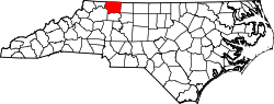
Website: www.co.surry.nc.us Surry County[1] ist ein County im Bundesstaat North Carolina der Vereinigten Staaten von Amerika. Der Verwaltungssitz (County Seat) ist Dobson, das nach dem Richter William Dobson benannt wurde oder nach William P. Dobson, einem Mitglied der Generalversammlung.
Inhaltsverzeichnis
Geografie
Das County liegt im Nordwesten von North Carolina, grenzt im Norden an Virginia und hat eine Fläche von 1393 Quadratkilometern, wovon 3 Quadratkilometer Wasserfläche sind. Es grenzt im Uhrzeigersinn an folgende Countys: Stokes County, Forsyth County, Yadkin County, Wilkes County und Alleghany County.
Surry County ist in 15 Townships aufgeteilt: Bryan, Dobson, Eldora, Elkin, Franklin, Long Hill, Marsh, Mount Airy, Pilot, Rockford, Shoals, Siloam, South Westfield, Stewarts Creek und Westfield.
Geschichte
Surry County wurde 1770 aus Teilen des Rowan County gebildet. Benannt wurde es nach dem gleichnamigen County in England, dem Geburtsort von William Tryon, dem Gouverneur von North Carolina von 1765 bis 1771.
Demografische Daten
Historische Einwohnerzahlen Census Einwohner ± in % 1790 7191 — 1800 9505 30 % 1810 10.366 9 % 1820 12.320 20 % 1830 14.504 20 % 1840 15.079 4 % 1850 18.443 20 % 1860 10.380 -40 % 1870 11.252 8 % 1880 15.302 40 % 1890 19.281 30 % 1900 25.515 30 % 1910 29.705 20 % 1920 32.464 9 % 1930 39.749 20 % 1940 41.783 5 % 1950 45.593 9 % 1960 48.205 6 % 1970 51.415 7 % 1980 59.449 20 % 1990 61.704 4 % 2000 71.219 20 % Vor 1900[2] Nach der Volkszählung im Jahr 2000 lebten im Surry County 71.219 Menschen in 28.408 Haushalten und 20.482 Familien. Die Bevölkerungsdichte beträgt 51 Einwohner pro Quadratkilometer. Ethnisch betrachtet setzt sich die Bevölkerung zusammen aus 90,40 Prozent Weißen, 4,16 Prozent Afroamerikanern, 0,23 Prozent amerikanischen Ureinwohnern, 0,57 Prozent Asiaten, 0,04 Prozent Bewohnern aus dem pazifischen Inselraum und 3,45 Prozent aus anderen ethnischen Gruppen; 1,15 Prozent stammten von zwei oder mehr Ethnien ab. 6,49 Prozent der Bevölkerung waren spanischer oder lateinamerikanischer Abstammung.
Von den 28.408 Haushalten hatten 30,8 Prozent Kinder unter 18 Jahren, die bei ihnen lebten. 58,4 Prozent davon waren verheiratete, zusammenlebende Paare, 9,7 Prozent waren allein erziehende Mütter und 27,9 Prozent waren keine Familien. 25,0 Prozent waren Singlehaushalte und in 11,7 Prozent lebten Menschen mit 65 Jahren oder älter. Die Durchschnittshaushaltsgröße betrug 2,46 und die durchschnittliche Familiengröße war 2,92 Personen.
23,6 Prozent der Bevölkerung waren unter 18 Jahre alt. 7,9 Prozent zwischen 18 und 24 Jahre, 29,0 Prozent zwischen 25 und 44 Jahre, 24,1 Prozent zwischen 45 und 64, und 15,4 Prozent waren 65 Jahre alt oder Älter. Das Durchschnittsalter betrug 38 Jahre. Auf alle weibliche Personen kamen 95,7 männliche Personen. Auf alle Frauen im Alter von 18 Jahren oder darüber kamen 92,2 Männer.
Das jährliche Durchschnittseinkommen eines Haushalts betrug 33.046 $ und das jährliche Durchschnittseinkommen einer Familie betrug 38.902 $. Männer hatten ein durchschnittliches Einkommen von 27.854 $ gegenüber den Frauen mit 20.556 $. Das Prokopfeinkommen betrug 17.722 $. 12,4 Prozent der Bevölkerung und 9,1 Prozent der Familien lebten unterhalb der Armutsgrenze. 15,0 Prozent von ihnen sind Kinder und Jugendliche unter 18 Jahre und 17,4 Prozent sind 65 Jahre oder älter. [5]
Siehe auch
Einzelnachweise
- ↑ GNIS-ID: 1008587. Abgerufen am 22. Februar 2011 (englisch).
- ↑ U.S. Census Bureau - Census of Population and Housing. Abgerufen am 15. März 2011
- ↑ Auszug aus Census.gov. Abgerufen am 20. Februar 2011
- ↑ Auszug aus factfinder.census.gov Abgerufen am 20. Februar 2011
- ↑ Surry County, North Carolina, Datenblatt mit den Ergebnissen der Volkszählung im Jahre 2000 bei factfinder.census.gov.

Liste der Countys in North Carolina
Alamance | Alexander | Alleghany | Anson | Ashe | Avery | Beaufort | Bertie | Bladen | Brunswick | Buncombe | Burke | Cabarrus | Caldwell | Camden | Carteret | Caswell | Catawba | Chatham | Cherokee | Chowan | Clay | Cleveland | Columbus | Craven | Cumberland | Currituck | Dare | Davidson | Davie | Duplin | Durham | Edgecombe | Forsyth | Franklin | Gaston | Gates | Graham | Granville | Greene | Guilford | Halifax | Harnett | Haywood | Henderson | Hertford | Hoke | Hyde | Iredell | Jackson | Johnston | Jones | Lee | Lenoir | Lincoln | Macon | Madison | Martin | McDowell | Mecklenburg | Mitchell | Montgomery | Moore | Nash | New Hanover | Northampton | Onslow | Orange | Pamlico | Pasquotank | Pender | Perquimans | Person | Pitt | Polk | Randolph | Richmond | Robeson | Rockingham | Rowan | Rutherford | Sampson | Scotland | Stanly | Stokes | Surry | Swain | Transylvania | Tyrrell | Union | Vance | Wake | Warren | Washington | Watauga | Wayne | Wilkes | Wilson | Yadkin | Yancey
Wikimedia Foundation.
Schlagen Sie auch in anderen Wörterbüchern nach:
Surry County, North Carolina — Seal … Wikipedia
National Register of Historic Places listings in Surry County, North Carolina — Map of all coordinates from Google Map of all coordinates from Bing … Wikipedia
Oak Grove, Surry County, North Carolina — Oak Grove is an unincorporated community in northern Surry County, North Carolina near Bottom. Contents 1 Geography 2 Architectural significance 3 Other places called Oak Grove in Surry County … Wikipedia
Mulberry, Surry County, North Carolina — Mulberry is an unincorporated community in Surry County, North Carolina. The center of the community is roughly the intersection of Mulberry Church Road and Poplar Springs Road. Located on Mulberry Church Road is Mulberry Primitive Church and… … Wikipedia
Dobson Township, Surry County, North Carolina — Location of Dobson Township in Surry County, N.C. Dobson Township is one of fifteen townships in Surry County, North Carolina. The township had a population of 8,088 according to the 2000 census. Geographically, Dobson Township occupies 69.1… … Wikipedia
Mount Airy Township, Surry County, North Carolina — Location of Mount Airy Township in Surry County, N.C. Mount Airy Township is one of fifteen townships in Surry County, North Carolina. The township had a population of 24,828 according to the 2000 census. Geographically, Mount Airy Township… … Wikipedia
Marsh Township, Surry County, North Carolina — Location of Marsh Township in Surry County, N.C. Marsh Township is one of fifteen townships in Surry County, North Carolina. The township had a population of 2,499 according to the 2000 census. Geographically, Marsh Township occupies 24.4 square… … Wikipedia
Franklin Township, Surry County, North Carolina — Franklin Township is one of fifteen townships in Surry County, North Carolina. The township had a population of 2,155 according to the 2000 census. The township was named for the family of Jesse Franklin, a former governor of North Carolina and… … Wikipedia
Shoals, Surry County, North Carolina — Shoals is a small unincorporated community in the Shoals Township of Surry County, North Carolina. Geography The community is located on the Yadkin River near Grassy Creek and is named for the nearby Bean Shoals rapids found in the Yadkin Harvard … Wikipedia
Elkin Township, Surry County, North Carolina — Elkin Township is one of fifteen townships in Surry County, North Carolina, United States. The township had a population of 6,524 according to the 2000 census.Geographically, Elkin Township occupies 21.3 square miles in central Surry County.… … Wikipedia
Surry County (North Carolina)

18+
© Academic, 2000-2026
- Kontaktieren Sie uns: Unterstützung, Werbung
Wörterbücher Export, schritte mit PHP, Joomla, Drupal, WordPress, MODx.